


A KEEPER JUST THE SAME
- Oct 29, 2025
- 3 min read
We finally got the rain machine running again Tuesday after another week long shut down. While it wasn't a drought breaker, it was helpful falling at a gentle pace along with cool temperatures, and no frost in the ground. There's no doubt we needed it, as rain has been at a premium since August 19th. Below are the rainfall departures in Iowa over that 71-day period, August 19th through Monday the 27th. Most of my area in eastern Iowa was 4.5 to 6.7 inches below normal before what fell Tuesday.

Dubuque was one of the driest locations in that 71 day run, with a grand total of 1.82 inches (a deficit of 6.35 inches). Normal totals would have been right at 8.13". During the stretch, only one rain over .28 inches was noted at the Dubuque airport, and that was just .57". The ground around here is hard as a rock.
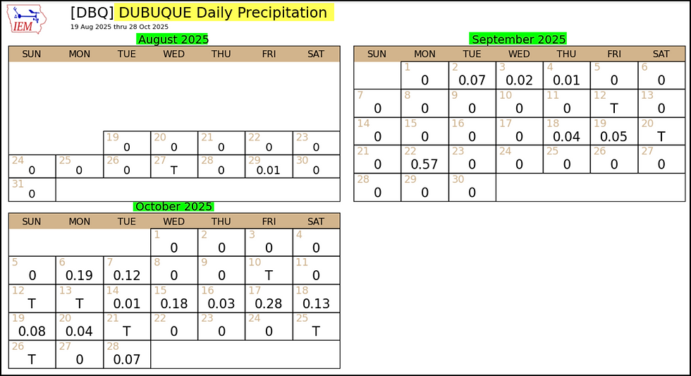
While the totals are not yet finalized as I write this, most locations in my area should end up with amounts of 1/4 to 1/2 inch. Again, that's nothing to write home about, but when you consider the numbers I just showed you, it's one of the better rains in 2 1/2 months. We'll take it.
VISIT US AT MY 5-STAR GALENA AIRBNB.

My 5-STAR AIRBNB just outside of Galena is a premier Midwest destination and a guest favorite! We take pride in our perfect rating, amenities and cleanliness. Take advantage of our fall and winter specials and instantly save $200. Book directly with us and eliminate AIRBNB fees and additional costs that will save you cash. Other discounts apply. Call or text Carolyn at 563-676-3320 for our best deal of summer. See more at https://www.littlewhitechurchgalena.com/
BACK TO DRY WEATHER FOR SOME TIME
It would be good to get additional moisture in the ground before the ground freezes, which it typically does by the end of November. But, based on the 500mb jet structure shown November 12th, a W/SW flow aloft is going to restrict moisture and after a cool 7 days ahead, bring above normal temperatures in the longer range. What you see below should bring a dose of serious Indian Summer weather, cool nights and mild dry days.

These are the 10-day temperature departures for the period November 3rd through the 13th.

Even more impressive are the 5-day daily temperature departures for the period November 8-13th.

The GFS meteogram has no serious signs of winter in it yet. Instead of getting colder going into November, it's trending warmer. The normal high in the Quad Cities November 13th is 49, ithe GFS is showing 74.

Over the next 7 days, the GFS has this for total precipitation. The lack of rain looks far too familiar.

The next 10 days rainfall deficits are climbing again towards an inch. That's takes away all that we gained Tuesday and then some. I really dislike this pattern.

As far as Wednesday goes, dry air will be pouring back into the area, inducing rapidly clearing skies from north to south as the morning unfolds. Brisk NE winds will make for a crisp day, but the addition of sunshine in the afternoon should get readings back into the mid to upper 50s.
That's about where temperatures should stay Thursday and Friday, before a reinforcing surge of cooler air drops in from the northwest Friday night. It may support some clouds and a few brief showers or sprinkles before dropping highs Saturday several degrees into the range of 49 north to 54 south.
Sunday, we close the weekend out with mostly sunny skies and highs in the mid to upper 50s. Readings remain seasonally cool through Wednesday, and then we shoot for the 60s the end of next week as warmer air makes another run at the Midwest.
By the way, chances are you have heard about Melissa, the category 5 hurricane which made landfall near New Hope, Jamaica around noon Tuesday. It tied the all-time record for strongest land falling hurricane in the Atlantic Basin, with winds of 185 mph (gusts higher). The pressure reached 892 millibars (that's 26.34 inches!) That ties it with the 1935 Labor Day hurricane, (which devastated the Florida Keys), for lowest pressure and highest winds. Here's a look at the concentric eye wall as it closes in on New Hope.

Only nine Atlantic Basin hurricanes going back to the 1800s have had peak sustained winds of 180 mph or higher.
With that, I will wrap this up. Here's hoping you have a sensational day. Thanks for visiting the site, and please hit the like button on my Facebook page if you feel it's warranted. Roll weather...TS


Comments