


NEW YEAR, NEW WEATHER...
- Jan 1
- 3 min read
Happy New Year, everybody! Thanks for making TSwails your home for weather information. Here's hoping 2026 brings plenty of interesting and exciting weather. Meteorologist Nick Stewart and I are committed to bringing you reliable, insightful, forecasts that you can trust without the hype. We take great pride in doing weather right!
Headed into January, the coldest month of the year, most of my local area has no snow on the ground, maybe a skiff in spots. That belies the fact winter to date is well ahead of normal with regard to snowfall. Here's what's fallen through December 31st. Most of my area has racked up 18–23 inches, with most of that falling by December 15th!

Expanding the view, you can see that since Thanksgiving, the predominate storm track has run from NW to SE through the Midwest and Ohio Valley. Will we revert to that later this winter? That's a question that remains to be answered?

Short term, snow is not likely to be a concern locally the first 10 days of 2026. The GFS indicates all the action is well to the north through January 10th.

The glaring reason why is the position of the storm track the next 10 days. 500mb heights are well above normal and predominately aligned in a westerly flow January 5th.

That produces temperatures near to above normal through January 10th. In fact, about 90 percent of the nation enjoys the mild readings.

This mild westerly flow is also very short on moisture. So, not only do we see no snow, we experience little if any rainfall the next 8–10 days. Mild, and dry, the best of both worlds.

On the topic of mild, the GFS is also quite bullish on highs beginning next week, showing a toasty stretch of weather January 5th through the 10th that includes a high of 66 in the Quad Cities Friday the 9th. I doubt we get out of the 50s, but without snow cover, that improves chances. I will also point out the change to much colder temperatures that are indicated around January 14th.

The EURO seems more reasonable with its more moderate highs during the warm-up next week and its slower approach with the late period cool-down, holding it off until after the 15th.

So while the short term forecast is rather straight forward, the long term aspect beyond January 15th continues to be a topic of much speculation, with the potential for a strong pattern change at that time. The 500mb jet January 22nd would leave the door wide open for Arctic air to penetrate much of the nation east of the Rockies.

These are the daily temperature departures for the 30-day period January 15th to February 15th on the EURO control. That's a month's worth of cold!

The coldest stretch is currently focused on the 7-day period January 20th to the 27th.

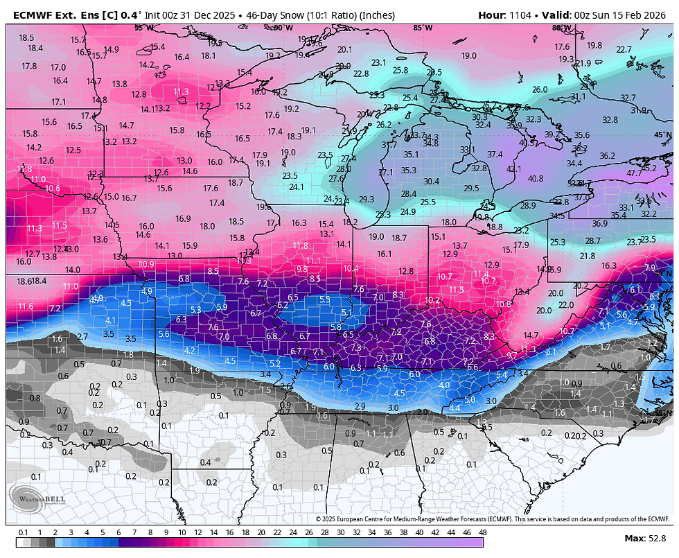
For the 4th consecutive day, the EURO control is generous on snow in the 30-day period January 15th to February 15th. I'm not focused on the amounts as much as the placement of the heaviest snow swath, which certainly impacts us as currently shown.
It's still early, but my confidence continues to slowly grow that the second half of January could more than make up for the mild start to the month. More to come. That's all for now on this first day of 2026. Make it a happy, healthy, and productive New Year! Roll weather...TS


Comments