


A LITTLE OF THIS, A LOT OF THAT
- Jan 15
- 5 min read
Updated: Jan 15
Well, it was nice while it lasted, but the reality is "winter break is over". Heading into the weekend, it looks like we're in for a little bit of snow and a lot of cold. Beyond that, teleconnections strongly support what should be a colder and a perhaps snowier period the remainder of the month. Keep your mukluks handy.
The transition started Tuesday night when a stout front whipped up northwest winds that howled all night and into the day Wednesday, with gusts of 38 to 43 mph common. Temperatures which hit 50 in spots Tuesday were 25–30 degrees colder at noon Wednesday, and with that fresh gale it felt far colder than that. Here's the 24-hour change in temperatures.

Now the floodgate is opening to cold air and Thursday morning temperatures are down around freezing as far south as Mobile, Alabama on the Gulf Coast.

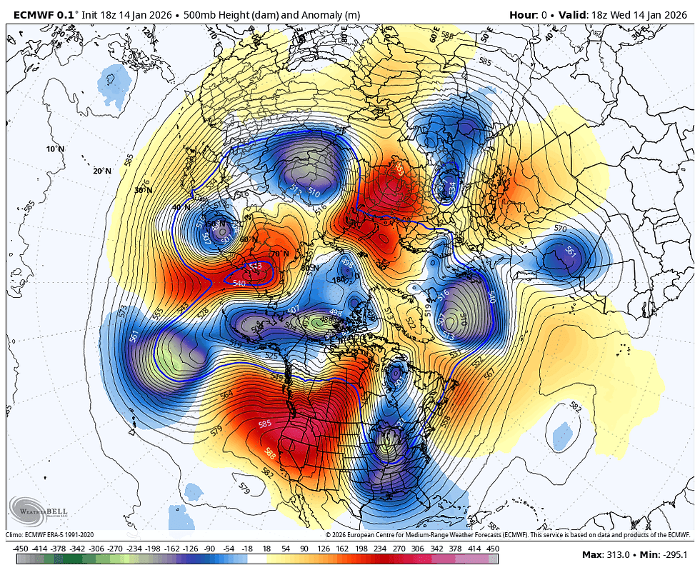
Now, let's take a look at the evolution of the 500mb jet stream into Tuesday of next week. A massive ridge builds from Alaska to the Pacific Northwest. In doing so, it forces a buckle and a deep downstream trough over the eastern U.S. You can see several lobes of energy diving southeast in the NW flow steering current. It acts like a slide for cold polar air masses to dive into the eastern half of the nation. Fortunately, the trajectory is such that the coldest air is just east northeast of my local area. Big picture it won't mean much, but it might save us a few degrees of pain.
We'll need every degree we can get with the EURO showing temperatures midday Monday in the single digits.

A stiff northwest wind has wind chills running 10-25 below zero.

If the EURO is right, things get worse the following Monday, when a new blast of Arctic air has temperatures that look like this. Lows in my area are shown 9 to 13 below.

Wind chills are again nasty, well below zero in much of the area.

Something special has to happen to see temperatures like that. One would be the addition of snow cover. Two, would be the Polar Vortex making a run at northern Minnesota. Indeed, we see its center displaced well south of its usual haunt, the North Pole on the EURO.

The operational EURO also shows a decent snow cover from my northern counties into Minnesota and Wisconsin. The deeper that is, the colder temperatures could potentially be. This is out in the 10-day time frame making it problematic, but the EURO has reasonably good skill scores within 10 days, especially with temperatures. As early as Monday morning, the ensembles of the EURO are showing a 90 percent or greater shot of sub-zero temperatures in the north. Chances decrease considerably SW of I-80.

Snow cover is much harder to nail down in the long range, but the ensembles show a 90-100 percent chance of an inch of snow on the ground from I-80 north when the core of the coldest air is indicated around the 26th. 70-90 percent odds are shown elsewhere. A snow pack is again is a key ingredient in maximizing the cold.

These are the average 7-day temperature departures shown on the operational EURO for the period January 22 to January 29th.

That has the potential to be a rough period, especially any morning around the 26th when the EURO shows temperature departures up to 30 degrees below normal.

Now, there is always the chance that this period around the 26th could be modified in future runs. Let's certainly wish that's the case because this is high-end cold and what I would consider the worst case scenario. I'm hoping we can back this down a bit going forward. It does, however, implicitly show the potential that exists in the coming pattern.
If you are interested in snow, I think the best shot at seeing something significant comes in the period January 21-29th, In that time frame the NAO (North Atlantic Oscillation) is negative as well as the PNA (Pacific North America Oscillation). That combination would likely set up a strong baroclinic boundary with very cold air north and mild readings across the southeastern U.S. That is a set-up that leads to a more classic storm that involves significant warm air advection, something clippers are short on. There's no certainty that will happen (or if it does, whether the track is close enough to impact my area). However, the 500mb structure near the 24th holds promise if it ends up close to this.

HOT DEALS INTO FEBRUARY....

SNARE A WEEKEND, (4 GUESTS FOR $499 total) My AIRBNB outside of Galena is ready and waiting. Enjoy our unique, fully renovated church. It's an AIRBNB guest favorite with 5-star reviews. Warm and cozy, even in the winter. Minutes from Galena. Call or text Carolyn at 563-676-3320 for details about this very special deal. https://www.littlewhitechurchgalena.com/
THE SHORT TERM SCOOP...
Now, with all this talk of cold, we do have a clipper that approaches from the north Thursday afternoon and night. The warm air advection that develops ahead of it won't impact readings much Thursday, with highs remaining in the range of 26 to 30 from north to south. However, clouds will be on the increase and some snow showers should pass through late in the day and evening. Amounts will be light in the range of 1/2 an inch or less in most spots, worst case scenario an inch in a few select spots before they move out around midnight. Another round with similar amounts is possible in the north early Friday.
Friday afternoon the clippers cold front passes with the threat of some additional snow showers in the afternoon or evening but again minimal if any accumulation is likely. Ahead of the front, temperatures will be warmer, with highs reaching the mid to upper 30s before the colder air arrives with its passage. That drives lows into the teens by Saturday morning. It also kicks up the winds. With strong cold air advection Saturday, we can expect a blustery day with some occasional snow showers or flurries, especially in the north. Minor accumulations are again anticipated. Temperatures will hold fairly steady in the mid to upper teens.
Sunday, ahead of an even stronger Arctic cold front, readings may climb into the low to mid 20s before it powers through by evening. Again, it may deliver some scattered light snow showers, but its primary impact will be to crank up the winds and drive temperatures into the range of zero to 5 above come Monday morning, thus ushering the cold air that should dominate much of the coming 2 weeks.
As for snow, models have eased up some since yesterday indicating amounts from all these small events in the range of .5 to 1.5 inches, thus minor impacts. A couple models still indicate a few isolated spots with up to 2 inches, so I will throw that out with some serious reservations.
The EURO

The GFS

The NBMv5 A blend of models and ensembles

Just to be clear, while it will be chilly the next few days, this is just the precursor to what I would qualify as real cold next week when the Arctic hounds will be singing a tortured song. Roll weather...TS


I dislike the snow and the frigid weather intensely. But it is actually very important for the Midwest region. Both environmentally and financially. So, just to look at things a little more positively.