


DIALING UP WINTER...
- Jan 13
- 4 min read
We got the week off to an exceptional start Monday with abundant sunshine, light winds, and highs in the range of 45-50. This comes during a two-week period where January temperatures have been running well above normal, as much as 13.6 degrees per day in Lowden, Iowa, according to my climate guru Steve Gottschalk. Included in that was a day last Friday when highs in the upper 50s to low 60s were found areawide. That produced exceptionally moist air that generated scattered thunderstorms and some prolific rains in northeast Iowa. The two-inch report from Guttenberg, Iowa is easily the largest single day precipitation report for the entire month of January, even more remarkable when one notes that there are only three other instances of an inch or more over a single 24-hour period since 1937.

We're going to break off another mild day Tuesday with highs that should range from 47 to 53. That puts us 20-25 degrees above normal.

Back in early January, I began promoting the idea of a pattern change that would lead to a much colder and more typical brand of mid-winter weather the second half of the month. Finally, I'm seeing the teleconnections line up to deliver the goods.
HOT DEALS IN JANUARY....

A January weekend, (4 GUESTS FOR $499 total) My AIRBNB outside of Galena is ready and waiting. Enjoy our unique, fully renovated church. It's an AIRBNB guest favorite with 5-star reviews. Warm and cozy, even in the winter. Minutes from Galena. Call or text Carolyn at 563-676-3320 for details about this very special deal. https://www.littlewhitechurchgalena.com/
THE REVERSAL...
I will start my argument for the change with the MJO. It's currently in phase 6 which strongly correlates to above normal readings in January. Right on target in that regard. However, in about 10 days it is expected to zip into phases 8 and 1, which in January is good for cold. What's interesting about that is, typically, we would remain mild until the transition is complete around the 23rd. However, I think there are a couple of reasons why that won't happen, with Polar air already charging into the pattern the middle of the week.
One, is the fact the MJO has not run the full gamut of warm phases 3,4, and 5 to reach phase 6 (it's coming out of the null phases, the circular area in the middle of the phase diagram below). That's not allowed cold air to be flushed out further north, especially from Canada into New England. In other words, it's close by and can quickly be tapped once the jet is positioned properly.
Second, as I will show you in just a bit, other teleconnections are already entering cold phases that appear to be over-powering the MJO. This happened back in mid-December, with the opposite effect, Then, the MJO was in phase 8 and should have been cold, however the EPO (eastern Pacific Oscillation) was positive and the WPO (Western Pacific Oscillation) was strongly negative. That combined with very warm air in the north Pacific beat back the cold air the MJO was signaling. That doesn't typically happen, especially twice in a month's time.

Anyway, the way things are lining up today, despite the MJO, we will get the ball rolling towards cold earlier. Then, by the last 8-10 days of January, all the teleconnections are aligned in cold phases, and this time I doubt the cold will be denied. If you look at the 500mb heights with a weak La Niña in phase 8 during January, this is what the phase correlation should mirror.

Compare that to what the EURO 500mb jet stream heights look like below for the 17th, and it is very much in the ballpark.
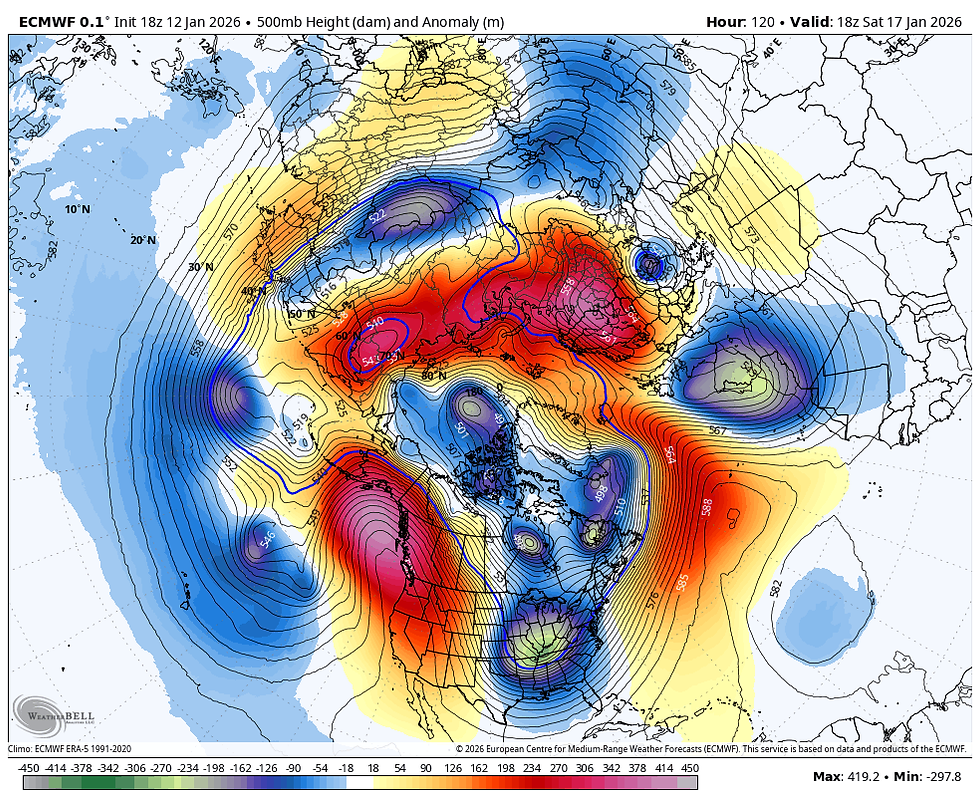
So you have the EURO showing the upper level pattern at 500mb depicting what the composite anomaly for temperatures should look like. That in itself lends confidence to the idea of cold. By the way, these are the temperature correlations for phase 8 and 1 in January, where we are headed.

Things really start clicking when you dig into the remaining teleconnections.
The AO (Arctic Oscillation), significantly negative, a cold phase.

The EPO (Eastern Pacific Oscillation) Very negative, a cold phase

The WPO (Western Pacific Oscillation) Strongly negative, a cold phase (especially with the EPO so negative)

The NAO (North Atlantic Oscillation) Trending strongly negative, a cold and potentially stormy phase east of the Rockies.

That's the dead man walking signal for a resurgence of below normal temperatures. Pretty high confidence.
Now, because of the MJO's insistence to play around in phase 6 and 7 the next 10 days, I expect to see some back and forth in temperatures before the cold can really take hold the last 10 days of January. These are the 10-day temperature departures for the week 2 period January 18-28th.

Both the EURO and GFS ensembles are showing some snow returning to the pattern. Here is what they are suggesting, at a 10:1 ratio over the next 15 days. Nothing massive, but since this is an average of many members with slightly different inputs, it's is an average of them all. Some higher, some lower.
The EURO ensemble snow.

The GFS ensemble snow

In the short term, we have our mild day on tap Tuesday, then the first of several NW flow clippers digs southeast. Each brings progressively colder temperatures. Some light snow is likely Thursday night into Friday night with the second surge of cold. Some accumulations of 1 to perhaps 2 inches are possible, as Nick alluded to in his last post. We'll know more in the next 24 hours how things are trending in that regard.
The first round of cold comes with plenty of wind Wednesday but nothing more than a stray flurry. Here's a sampling of what is on the table going forward, according to the EURO. Looks like January to me.
The EURO

Enjoy Tuesday's mild conditions, it's quite likely the warmest day we'll see the rest of this month. Roll weather...TS
TSWAILS.COM expert weather consulting services (CLICK FOR MORE)

Private consulting
Legal forensic services as an expert witness
Public speaking engagements for groups or individuals
Post storm analysis
A private day-long weather school class
Specialized events forecasts
Severe weather seminars
Lectures and training
Climatological services
Meteorological workshops.


Comments