


A PATTERN SHIFT IS LURKING
- Oct 12, 2025
- 2 min read

Spotty light showers Saturday evening and overnight as expected did not amount to much, but a stronger storm system late this week is worth watching for not only some appreciable rain amounts but also finally a trend towards near/below normal temperatures. A rather potent trough is likely to pass through the CONUS late this week into the weekend - the upper air support for a strong storm system.

Ahead of the late-week storm there will be another chance of light showers late Tuesday that once again will not amount to much. A trace to maybe a tenth of an inch at best. This will be in the midst of above normal temperatures that will stick around through the start of the week.

Five-day temperature anomalies on the European Ensemble will sit 5-10° above normal through Saturday. Once we get through this last burst of warmth the trend will be heading towards a cooler and more seasonal regime late in October.

The model blend shows highs backing off into the mid/upper 60s once this pattern shift takes over by Sunday of next week. This would again not be a major Arctic blast or bring snow chances despite what a lot of these hype pages have been posting, but more so a return to what should be more normal for the Midwest in autumn.
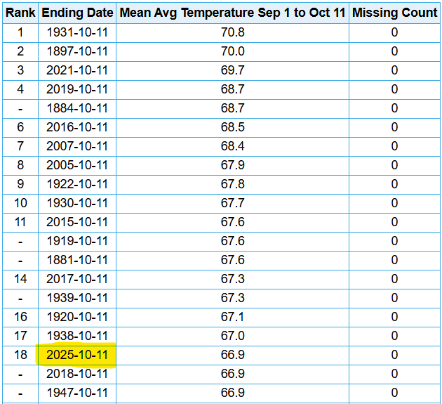
For awareness, thus far meteorological autumn through Oct. 11 is the 18th-warmest to date for the Quad Cities, or in the top 12 percent of years on record. It's certainly been a warm one.

In terms of precipitation with the upcoming system, we are on the northern fringe of the heaviest rain based on the Ensemble mean, and I believe this to be somewhat optimistic. It seems the heaviest rain will likely be to the south, and this includes any severe weather risk that may also develop.

The official rain forecast from the Weather Prediction Center notably puts the area in the lowest rain total over the next seven days, the the heaviest rain staying south of the area which is attributed to the weekend storm. Once again, so close but so far.

I'll wrap up with the potential for strong storms with the weekend storm system. The signal is somewhat muted, but the higher severe chances are in the Southern Plains. In other words, we'll be lucky to get measurable rain let alone any strong storm risk.

I got my pumpkin to celebrate the cooler temperatures coming in this week! Enjoy the week!
-Meteorologist Nick Stewart


Comments