


A STORMY PATTERN LIES AHEAD
- Nov 16, 2025
- 3 min read

The signals are all pointing to a fairly active stretch of weather through the week, especially late week, as a rather strong autumn storm takes aim on the central US. The details on location, timing and exact impacts remain to be seen, but locally we will need to be on the lookout for some potentially heavy rain, relative to the time of year.

Seven-day precipitation forecast from the Weather Prediction Center shows a rather active pattern across the central United States. Locally, 1.0-1.5" is in the range of forecast with much higher totals down to the south. This will likely, once again, mainly swing to the south but I don't think it will be a completely dry passage for the region. The main thrust of activity looks to be Thursday through Saturday, but there's an early-week system to discuss as well.
THE EURO

THE GFS

Both operational global models show a fairly weak system pass through the region Monday into early Tuesday. Temperatures will be warm enough where this will be a rain event for the area. Some cooler temperatures to the north may lead to some snowflakes mixes in across areas of Minnesota and Wisconsin. Overall this should not amount to much with heavier totals to the north across southern Minnesota and Wisconsin along a stalled boundary. Locally, perhaps 0.10" to 0.20" will be possible with totals up to 0.50" possible to the north.
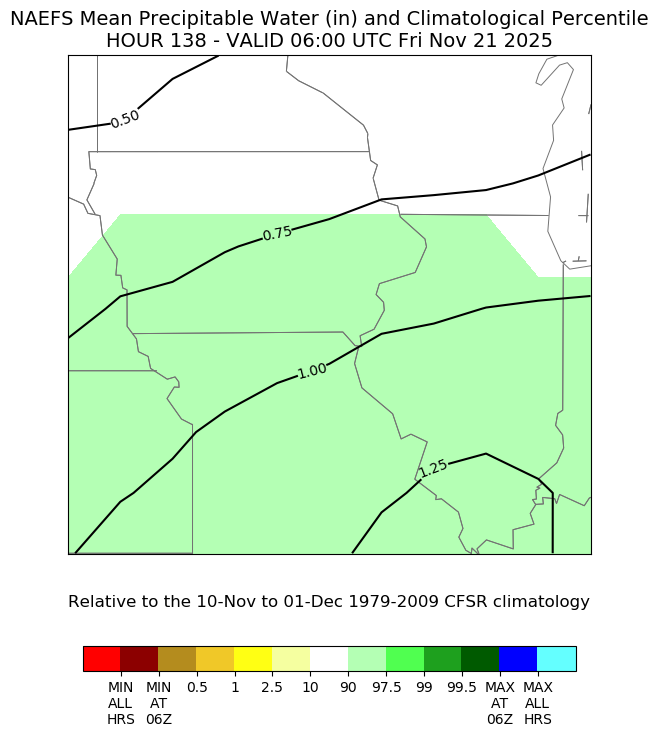
The late-week system is one to watch as there will be a rather high amount of moisture over the area to work with. Guidance is indicating precipitable water values in the 90th percentile, or between 0.75" and 1.0". That would be quite enough to produce some heavy rainfall for this time of year.

Ensemble guidance off the GEFS shows above-normal precipitation forecast locally, but the highest concentration of the heaviest rain will likely be to the south. This seven-day anomaly map will take us into early next week. There is a modest chance there may be some severe weather potential across the Southern Plains with this system as well.

Machine learning severe weather forecasts are starting to show increasing severe weather potential Thursday as our late-week system starts to kick into gear. I think this could continue into Friday across portions central and southern Illinois as well. We'll have to see how exactly the systems develops.

This is not too far off from severe weather climatology deep into November where chances are pretty small, but existent for the southern Mississippi River Valley region. Late November heading into Thanksgiving there are some signals for another storm system in the region that may have some cold air to work with. We'll talk more about that tomorrow.

I'll wrap it up with a look at temperatures in the week ahead. A warming trend is likely going forward after a brisk start to your Sunday in the upper 20s/low 30s. Notice behind the late-week storm temperatures do not really fall off a cliff too much. Late November into December is when we might see some more significant changes.
Have a great rest of the weekend, Friends.
-Meteorologist Nick Stewart

TSWAILS.COM is now proud to offer expert weather consulting services, including:
Private consulting
Legal forensic services as an expert witness
Public speaking engagements for groups or individuals
Post storm analysis
A private day-long weather school class session
Specialized meteorological needs
Severe weather seminars
Call 563-676-3377 or email terryswails1@gmail.com


Comments