AND THEN THERE WAS SNOW...
- Nov 12, 2021
- 4 min read
SUCH A PROUD MOMENT...

YOU GUYS ARE THE BEST... 332 of you generous individuals have made a voluntary $12 dollar donation to TSwails.com. I still need the support of 68 more of you to keep things going. Thanks to your generous donations to date, we are well on our way and with just a little more help we'll achieve our goal. All I'm asking is that if you enjoy the site and see value in it, please consider a voluntary subscription. I'm asking $12.00 dollars for a year. That's $1 dollar a month or 3 cents a blog if you consider the fact there were 450 posts issued over the past year. The site requires a significant commitment of time and resources and every donation, whatever the size is deeply appreciated. I just need a little help to cover the expenses. Click on the link below if you can assist or or need additional information. I thank you for your support and consideration.
WHAM BAM, NO THANK YOU MAAM...
The transition is nearly complete. First it was rain, then wind, cold, clouds, and finally snow showers. Once the flakes fly Friday the cycle will be complete in this dramatic change from upper 60 degree warmth to the winter ahead. A wham bam deal to be sure!
This has all come to pass thanks to a potent storm which is centered over NW Wisconsin. Thursday behind the cold front my area was situated in the dry slot where sunshine is evident but gusty and colder winds are not.

A testament to the strength of the system are the advisories that were in place Thursday just to the west. Snow was flying with a whole host of winter weather hazards including blizzard warnings in NE South Dakota.

Temperatures to the NW were hovering around freezing with gusty winds of 30-40 mph+. That cold air spins southeast into the region Friday.

Wind chills are pretty ugly as well with mid-day readings in the teens and mid 20s. All weekend we'll be looking at wind chills locally of 20-30 degrees. Ouch....

A FLAKY FRIDAY AT TIMES...
Friday promises to be an interesting day in that snow showers or snow squalls are expected to be ongoing from time to time much of the late morning and afternoon. This set-up is tied to very cold air aloft. Temperatures a mile up at 850mb are expected to dip into the range of -8 to -10C in the afternoon.

That drives steep lapse rates which indicates significant instability. Snow showers cellular in nature will grow vertically as they pop up randomly and try to link up in bands. These will move fast but because of the vertical component could produce brief but intense snow squalls that could limit visibility, especially with winds 30-40 mph. A few select areas could see up to 1/2" of accumulation but in general amounts should be no more than a dusting on grassy and elevated surfaces. The heavier squalls are likely to occur over the north half of my area, especially near and north of HWY 30. In the depiction below you can see the cellular nature of the snow and how it generates spotty accumulations that are heavier in spots than in others.

The NWS outlook issued by the Quad Cities shows totals that are generally 1/2 inch or less.

Here's some of the listed odds for seeing snow of 1/10th of an inch or more

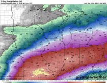
The Weather Prediction Center indicates where the greatest chances of an inch or more of snow are anticipated across the Midwest. The best odds are well northwest of my area.

Instability wanes Friday evening and any remaining show showers will be out by midnight. However, clouds and blustery conditions will be with us through Saturday evening. Highs both Friday and Saturday hold in the mid to upper 30s. Wind chills both days will range for the upper teens early in the day to the mid and upper 20s in the afternoon.
CLIPPED BY A CLIPPER...
Saturday night another fast moving disturbance cuts southeast from North Dakota into northeast Iowa. This brings another chance of rain or snow showers after midnight. Current indications are the system's snow (which could accumulate 1 to 3") should largely just catch or remain slightly north of my area. Models are now in two camps regarding the track and intensity so confidence is still lower than I would like to see. The end result will depend on how much the system can dig which influences how much cold air is available for snow production and where. My take for now is that the northern solution of the EURO prevails and all but the far north near HWY 20 avoids accumulating snow. Here's what the EURO shows.
The EURO

The GFS and several other models are further south. I can't say that won't happen but I think the northern solution is more likely and the way to go. Here's the other options on the table that I find too far southeast.
The GFS

The 3k NAM

The 12K NAM

Needless to say, the weekend ahead is far from perfect but not far from what's possible for mid November. Like it or not, this is a precursor of what the next 4 months are all about. That's where I will leave it for now. Thanks for your time and if you appreciate the site please consider a donation by clicking the link below. The future of TSwails is in your kind and caring hands. Roll weather...TS


Comments