THE BATTLE MAP IS GETTING A LITTLE MORE CLEAR
- Nov 22, 2025
- 3 min read

Overall prior to Thanksgiving it looks like a somewhat benign pattern still. A weak system late Monday into Tuesday will lead to rain showers across the area, but the weekend is when we continue to watch for potentially more potent issues.
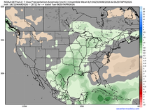
Virtually every member of the American GEFS (above), the 20-member ensemble forecast, has a storm somewhere in the Saturday Nov. 29 through Monday Dec. 1 time frame which could have impacts during one of the most traveled days of the year. This will likely feature rain and thunderstorms (some strong) on the warm side with snow (potentially heavy) on the cold side of the system.

Confidence is low on timing, area and exact impacts however the confidence is medium to high that there will be a system to watch. As it stands today the spread in the models remains about 900 miles. Typically I don't like to discuss these events unless there could be some rather large impacts (travel) and the conversation is being driven by hype pages (which it already is).
It seems like the Midwest is firmly in the battleground for this system where the northern half could be on the colder, wintry side and the southern half is on the "warmer" rainier side. For example:

The 50 members of the European Ensemble (a weather model which runs a forecast with slightly differing conditions to start) shows quite a snowy pattern for the Twin Cities, Minnesota. The mean over two weeks is 8" with many members over a foot of snow. Very few of the 50 members are under about 4" of snow.

Meanwhile in St. Louis, Missouri the mean is just 1" of snow with few few members over 4". While we can't talk specifics for cities, based on this guidance coming in, the northern half of the region looks like the colder and snowier play with our area (eastern Iowa and northern Illinois) potentially right on the storm track which makes for a much more difficult forecast.

For the Quad Cities the mean is sitting at 4" over the next two weeks but there is quite the spread in the low and high end indicating a low-confidence forecast. Some members are pushing a foot of snow, with a few less than an inch. I think sometime between Thanksgiving and the first weekend of December will feature snow in the Quad Cities but the timing and amount is highly uncertain.

The long-range Weather Prediction Center forecast at day 7 (Saturday Nov. 29) is showing the general battle map that we may be dealing with next weekend. Snow to the north with the storm track near our area putting us in the chance of rain, to wintry mix to then snow. A track farther south would result in a weaker system but one that could put more snow on top of us.

For the snow and colder lovers there is a fly in the ointment. Current snowpack us running behind across southern Canada and the United States This generally will impact how far south a system will track and how much cold air it will have to work with. While at face value this would conceptually keep the heaviest snow to the north of the area, the storm track may be just far enough to keep areas along/north of the Iowa/Missouri border in play. A LOT can and will change between now and then so we will be very closely watching the situation ahead especially given the Thanksgiving travel conundrum.

The Climate Prediction Center maintains a Slight Risk of heavy snow (generally 5"+) for this system and notice we are right on that line. I think this setup is going to be a close one, that is for sure. Overall I agree heavily with the general idea of the map above with the best chance for snow, as of now, sitting about Omaha to Chicago and points north.

For the first week of December behind this initial system, below-normal temperatures will be a big story for much of the Unites States and the Midwest. I'll be sitting nice and warm in Florida, sorry y'all.

Temperatures early this week will remain mild in the mid/upper 50s before we cool off behind the late Monday/Tuesday rain event. The bigger drop in temperatures will be behind the following storm early next week. Current guidance sends temperatures off a cliff, but that likely won't last too long as another system around the Dec. 5-7 time frame will have a burst of warmth before another, likely more significant, cool down. But that's enough for now.
Have a great rest of the weekend, everyone!
-Meteorologist Nick Stewart


Comments