


BENEFITTING FROM SOME RAIN, FINALLY
- Sep 18, 2025
- 4 min read
The radar showed some life Thursday evening across eastern Iowa and much of Missouri with showers moving through and persisting into the overnight hours. While not adding a lot of rain, for many areas especially around the Quad Cities through Central Illinois, this is the first rain in September. We are entering a slightly active pattern through Saturday as we've been discussing, but overall not expecting this to be a heavy rain event through Sunday.
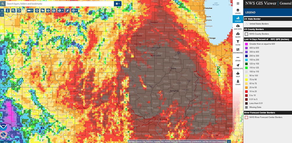
Looking at the percent of normal rainfall across the region over the last two weeks, zero percent is a common number from about Davenport southwards towards St. Louis and east to Champaign, Illinois. We will make a bit of a dent to this ugly number in the days ahead, but again we will not see any real drought-busting totals.
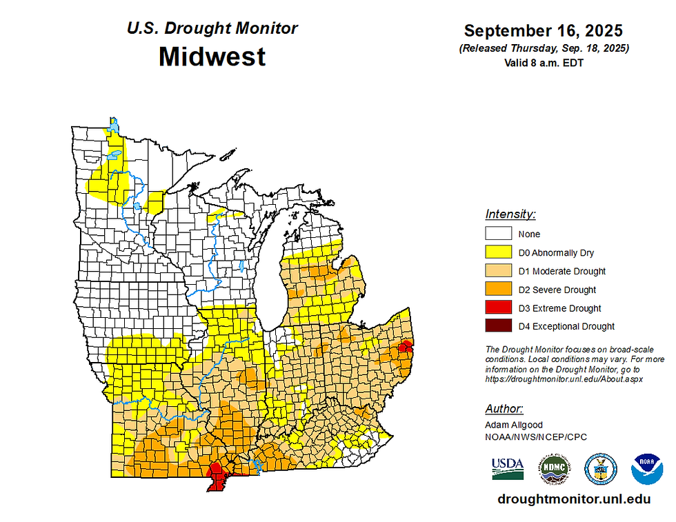
The latest drought monitor shows an uptick in dry conditions across southern Iowa and northern Illinois. The spread of Moderate and Severe drought has really increased over the last two weeks with even Extreme Drought now reported in far southeast Missouri. Trends have been quick abysmal for rain under a stubborn patter, but we are seeing this finally break down some.

Rain chances will continue Thursday night into Friday morning, with another round of scattered showers and a few thunderstorms Friday evening. This will again be pretty scattered in nature, with storms expected to be quite isolated, so impacts to high school football games across the Tri-State region looks pretty limited.

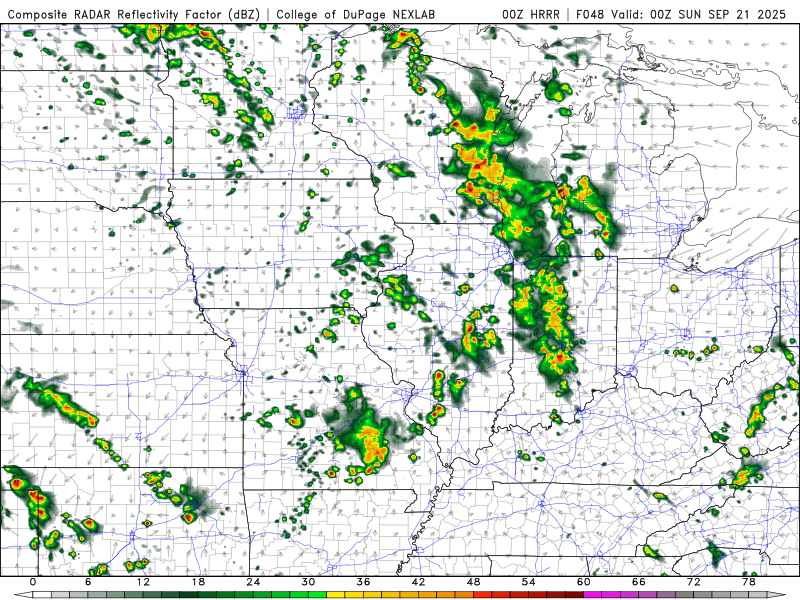
The HREF, which is an ensemble of all the high-resolution models has pretty meager rain amounts in southeast Iowa and along the Mississippi River with the highest totals clipping northeast Iowa into Minnesota and Wisconsin. So again, not everyone will see the magical water falling from the sky, those that do shouldd consider themselves lucky.

The Euro Saturday is a little more generous with rainfall totals for the area with widespread 0.25"+ totals. This I think might be too generous as I think the rain will remain more scattered in nature, especially across Iowa and northern Illinois. Better forcing up in Minnesota and Wisconsin will likely squeeze out a little more rain.

The HREF ending 7 p.m. Saturday does not look too bad, especially across southern and central Iowa. Eastern Iowa and northwest Illinois would likely receive the higher rain chances near and after this cutoff and is not well reflected in the image above, and that is where the Euro's depiction could be useful.
With that said, the HRRR which is at it's farthest hour (Saturday 7 p.m.) has pretty spotty, light showers over IL/IA and not a lot off accumulation. Don't get your hopes up for a decent rain, but there at least will be showers and a few rumbles drifting through the region.

Over the last few days, I mentioned my hesitancy to believe in heavier rain totals as "when in drought, have some doubt." While not well reflected in the drought monitor, the soils have rapidly dried out causing I think some issues with models depicting rainfall. The experimental flash drought monitor highlights the rapid drying and flash drought conditions locally showing just how fast things are drying out.

Across northern Missouri and Illinois the soil moisture levels are near record lows, with daily rankings Sept. 17 slipping into the 1st percentile - or in the lowest on climatological record. The size of this across west-central and central Illinois is quite alarming, especially headed through the harvest. Without beneficial rainfall we could see some major issues on tilled land and brisk winds. We have seen dust storm warnings in Illinois earlier this year, and fatal crashes on highways due to zero visibility with blowing dirt/dust. Without some major change here, I think we might have some problems in autumn.

The latest long-range Euro ensemble shows some troubling signs late September through the first half of October with below-normal precipitation being the favored outcome. Before we get there, however, we do have another storm system early next week in addition to our weekend rains. Hopefully that could overperform to help us out, but I am not too sold on it as of yet - at least locally.

The latest forecast from the Weather Prediction Center has the next storm system Monday night into Tuesday with some beneficial totals across the region. This does look better than this weekend in terms of actual widespread rainfall, but the heaviest axis of rain continue to look mainly south of the area.

The 24-hour mean rainfall on the European ensemble keeps that heavier rainfall to the south, with a notable trend in the last few runs. Several members do have higher totals up this way at least, for now, keeping the mean near 0.25" which the WPC heavily uses in their extended forecast as a blend of models.

Looking at the actual probabilities of 0.25" for the area, however, are less exciting with 25-35% chances at this point, and the heaviest percentages more towards the Ohio River Valley.

We'll continue to watch the next one! Have a a great weekend, friends, from the Florida Space Coast.
-Meteorologist Nick Stewart


Comments