


BITTER COLD, BUT NOT FOR LONG
- Jan 30, 2023
- 2 min read

A cold blast is expected across the Upper Midwest to start the first week of February and it times well with another burst of cold air back in 2019 (pictured above). On January 30, 2019 the city of Cedar Rapids, Iowa plummeted to -26 setting the record cold temperature for the date. That night, the mercury dropped all the way to -30: the all-time coldest temperature ever measured in the City of Five Seasons. The wind chill dropped to -55.
In the Quad Cities, the thermometer dropped to -31 on January 31, 2019 which was the second-coldest temperature ever measured, only surpassed by January 7, 1887 when it was -32.
The incredibly, dangerously cold temperature created fascinating atmospheric optics in the sky like a solar halo, sun dogs and upper-tangent arcs. Beautiful stuff if you found yourself outside.

So back to this week ahead, following a fresh coating of snow a strong Arctic High is returning to the Upper Midwest and will bring a shot of sharply colder temperatures to the region.
Wind chill values Monday night into Tuesday will drop into the -10 to -20 range for much of eastern Iowa into northern Illinois with values below -25 across northern Iowa into Minnesota.

While not outlandishly strong, the Arctic High will strengthen to about 1038mb right over the region leading to clearing skies, and a calm wind, which is a recipe for strong radiational cooling.

Tuesday night into Wednesday will once again be bitterly cold, however not as extreme with wind chill values from about 0 to -10 expected.
Certainly cold, however this Arctic shot of cold air does not want to stick around too long.

Looking at the Euro, temperatures go back above normal headed into next weekend with a chance for 40s back in the forecast. The pattern continues to favor this moderating of temperatures into the middle of February and beyond.

The latest MJO teleconnection run shows a strong return to phases five and six which is a very warm signal in the United States this time of year.
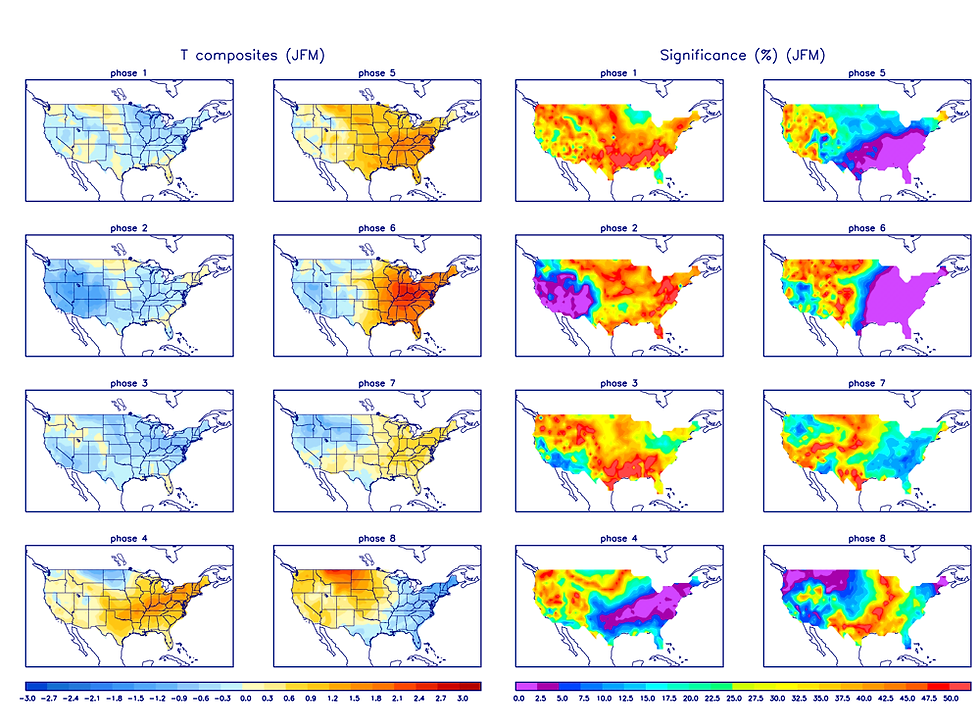
The chart above shows the likelihood of above normal temperatures and you can clearly see the warm phases of four, five and six which is right where the MJO is headed. Snow lovers, and cold lovers, may have to go on yet another extended break from the wintry weather.
Have a great week everyone! It was good to fill back here for the weekend but your regularly scheduled programming with Terry and Rebecca is back on track this week. Stay warm!
-Nick Stewart


Comments