


BLAME IT ON A BLIZZARD...
- Jan 28
- 4 min read
Updated: Jan 28
WHY SUPPORT T. SWAILS
Going on 50 years now, I've been a meteorologist. My focus was mainly television, although I've worked in all forms of media, including newspapers and radio. My interest in weather runs so deep that I have been compelled to publish 4 books on the subject, hold weather seminars, and be asked to act as a weather authority as an expert witness and keynote speaker. One of the foundational goals of my life is wanting to understand weather and perfect the art of forecasting. There is no doubt in my mind that this is what I was put on this earth to do.
When I was a kid, I would cut out articles... CLICK TO READ MORE....

BLAME IT ON A BLIZZARD
There was no shortage of sunshine Tuesday, but unfortunately it's not the only measure of a good day. Highs in the teens and a wicked wind up to 35 mph produced sub-zero wind chills and made a good-looking day far from a pleasant one, especially if you were out in it!
Not to be a Debbie downer, but the chances of anything much better remains low into the weekend. If you want to blame something, put it on a blizzard that looks to ravage the Carolina's and Virginia towards the end of the week. In the animation below, you can watch as a harmless, 1017mb low pressure develops over the Gulf near New Orleans. 24 hours later it crosses Florida and enters the Atlantic still only 1010mb. About that time it hits the warmth of the Gulf Stream and explodes into what's known as a meteorological bomb, a 968mb low. A bomb cyclone is a storm that rapidly intensifies with the central pressure dropping 24mbs or more in 24 hours. This one on the GFS is shown dropping 38mbs from 1006 to 968mbs from Saturday morning to Sunday morning. That causes explosive development of high impact conditions that include intense winds, blizzard conditions in the cold sector, and heavy precipitation surrounding the circulation.

While it remains to be seen how far inland snow falls over the east, the GFS is far enough west with its track to nail much of North Carolina and Virginia with 1 to 2 feet of snow.

It also shows wind gusts of 60-70 mph+ along the coast from Cape Hatteras all the way to Cape Cod.

If the GFS is correct, this would be an epic storm for parts of the mid-Atlantic with shut down effects. The EURO is not quite as intense and little further east with the track. Even so, it has made a jog NW towards the GFS. There is a lot of cold air available over the east and when the energy hits the warm water of the Gulf Stream it certainly could blow up. In doing so, it increases the chance the storm could run right up the coast causing lots of havoc. This will be a fun one to watch.
From the standpoint of storminess, the system will have no impacts this far west. However, even if the system just grazes the East Coast, it will impact the hemispheric wind patterns as it carves out a deep east coast trough. In other words, it blocks the jet stream pattern. Here in the Midwest that leads to a strong northerly flow aloft that draws cold air into the middle of the nation. That keeps us nice and fresh the remainder of the week. Check out this animation showing how the 500mb heights in a healthy NW flow behind the storm heading up the Atlantic.

These are the daily temperature departures shown the next 5 days ending February 1st. Locally we are shown 12-16 below normal per day.

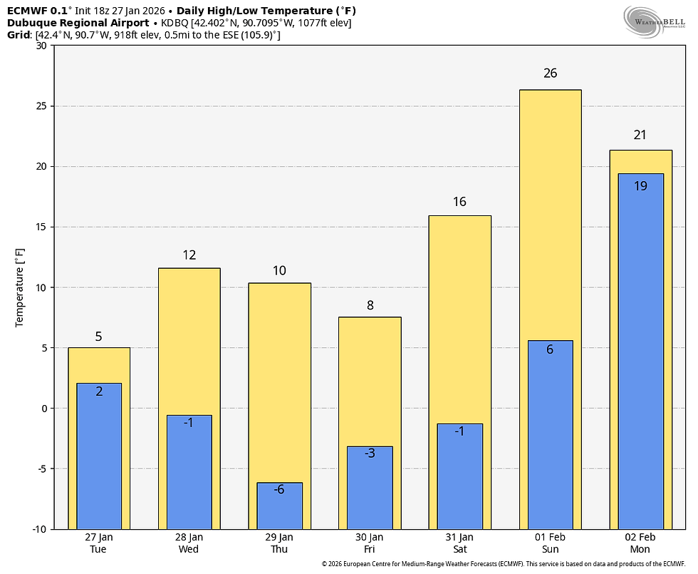
In the Quad Cities, that translates to temperatures like this through Sunday.

Up north where there is more snow cover in my northern counties it's a good 6-7 degrees colder in Dubuque for the same period. In fact, here in Dubuque if we can hit zero by midnight, quite possible with the cold to come we could eventually put together a run of 10 consecutive days with lows of zero or colder. That's not easy to do!
Now, here's something positive to build on with regard to moderating temperatures. It's the PNA (Pacific North America Pattern). It's currently in a highly positive phase, but shown trending negative early next week.

That's an important change because positive phase favors an east based trough, NW flow, and below normal temperatures locally. The negative phase signifies a shift to a west based trough and more of a ridge over the east, basically a full reversal.

What's unknown is how deep or far west the trough will become established. However, it not only should moderate temperatures, it would open the center of the country up to moisture and a better chance of precipitation, which is currently non-existent. Below are the week 1, 2, 3, and 4 temperature departures on the EURO weeklies through the end of February. You can see the cold of week 1 in the positive PNA, warmer readings in the negative PNA week 2. After that the PNA goes fairly neutral and a negative AO and NAO keeps things colder again in week 3 and 4.
WEEK 1 through February 3rd

Week 2 through February 11th

Week 3 through the 18th

Week 4 through the 24th

The precipitation totals for the 32-day period ending March 5th are decidedly wetter, which does imply SW flow that's able to deliver moisture. I do look for a more active period starting mid-February.

That's a wrap for tonight. Roll weather and please contribute what you can.

Hi everyone, as you know, TSwails.com is a no-pay site; existing on voluntary personal donations. Every year I ask those of you who find value in the site to make a financial donation you feel is worthy. Please reflect on the number of times you have visited us in the last year. If the information or knowledge you gained was valuable, it's my hope you will join the loyal group of contributors that's kept TSwails.com operational since 2013. I'm suggesting $20.00, which is roughly 4 cents a day. Less than 4% of my readers donate, so your gift, no matter the size, is not only appreciated, it helps immensely.
PLEASE CLICK HERE TO ASSIST


Comments