


OTHER'S PAIN MAY BE OUR GAIN
- Jan 26
- 3 min read
I COULD VERY MUCH USE YOUR ASSISTANCE

Hi everyone, as you know, TSwails.com is a no-pay site; existing on voluntary personal donations. Every year I ask those of you who find value in the site to make a financial donation you feel is worthy. Please reflect on the number of times you have visited us in the last year. If the information or knowledge you gained was valuable, it's my hope you will join the loyal group of contributors that's kept TSwails.com operational since 2013. I'm suggesting $20.00, which is roughly a nickel a day. Less than 4% of my readers donate, so your gift, no matter the size, is not only appreciated, it helps immensely.
PLEASE CLICK HERE TO ASSIST

Trends heading into the start of the week are favoring yet another powerful storm developing in the southeast and moving up the I-95 corridor from Florida to Maine. The Euro above is a rather remarkably strong trough that could send another strong shot of cold, and even snow, in unusual places. The way this is forming, however, may actually benefit the central US in terms of breaking the cold weather pattern we've been stuck in.

The American GFS is similar in terms of location and strength - a telling signal and a rather dramatic change from where this pattern looked yesterday, however this does better fit the pattern I discussed yesterday in terms of a pattern flip and ridging building in the central US.

While there are some mixed signals in some of the teleconnections, I think the PNA continues to be the main driver for the weather pattern in the next 7-10 days. This is trending strongly positive - 3-4 standard deviations upward from where we stand right now. A positive PNA generally is more average to slightly-above average in the central US with a ridge building. This however could cause east-coast troughing as a result.

Looking at January/February historical records for a PNA at 1 or above the signal favors exactly what the modeling is showing with east coast troughing and a ridge building in the western CONUS. This pattern flip is what we could use to get rid of the cold and bring in warmer temperatures. The lack of snow cover in the region additionally means it would not take long to actually warm up once a return to southwesterlies takes effect.
Temperature Anomalies - Friday

Temperature Anomalies - Monday
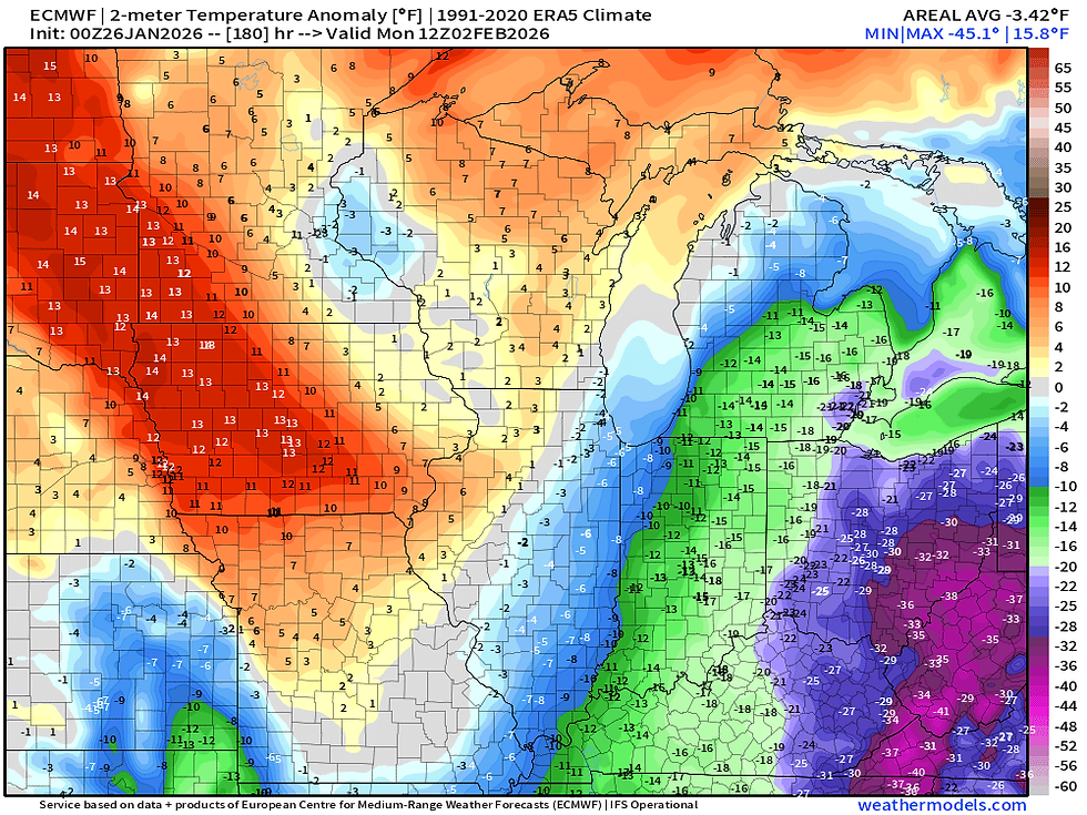
A look at temperature anomalies on the European model show this general flip in the pattern with colder than normal temperatures through the end of the week and a warming trend into early next week. This would be quite a welcomed sight!

Five-day average temperature anomalies on the Euro ensemble show this warming trend continuing into the first full week of February, and the fetch of above-normal temperatures extends well into the Pacific Northwest. This points to not only a quick pattern flip, but rather a longer-lasting trend towards warming temperatures into February.

Overall in the short term, cold is the main story with dangerous wind chills Monday and Tuesday. A quick-moving clipper Monday night could bring some light snow, but models keep the bulk of the action to the north. This will also send a reinforcing shot of colder air, but as mentioned above the cold air may be coming to an end (at least temporarily) early next month.
-Meteorologist Nick Stewart


Comments