


COLDER AIR BUILDING AROUND THE CORNER
- Jan 12
- 3 min read
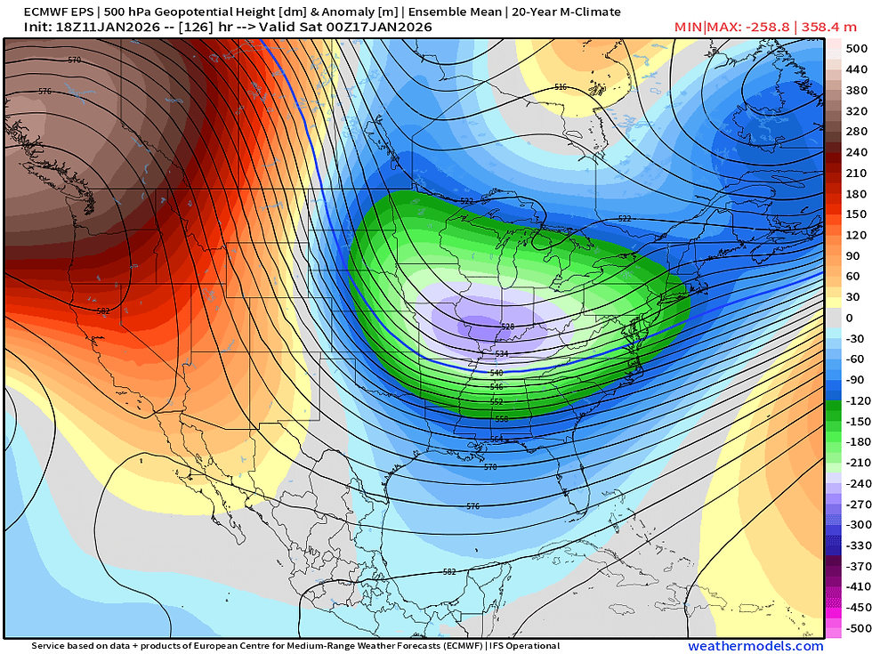
While short-term weather is somewhat quiet (up and down temperatures, yawn) the long-range forecast is starting to get a little more interesting and that could likely feature some colder temperatures more reminiscent of winter. Above you can see the European Ensemble for late this week with a big trough over the Great Lakes region. Northwest flow will be on the cooler side of normal with also mainly dry conditions with that northwest flow as well.

So far this meteorological winter (Since Dec. 1) the area has been on the warmer side of normal compared to historical record - roughly in the warmest 55% of years. So not necessarily significantly warm but on the warmer half. The next two weeks could change this.

A big driver I believe will be a rather strongly negative EPO (East Pacific Oscillation) over the next week. This is primarily characterized by strong ridging over Alaska, which would lead to troughing over the central and eastern US. That troughing could keep temperatures colder and the pattern drier. Most other teleconnections like the NAO and AO are close to neutral so I don't see them as a major driving force.

Analogs are starting to jump onto the idea of this cooling trend with temperature anomalies trending colder early next week. The values are starting to indicate about 5--10° below normal during this period averages over a three day stretch. So the signals are lining up for a cooler stretch of weather.

One limiting factor to a more intense shot of cold air will be the continued lack of snowpack across the region, especially "up wind" of that colder northwest flow. You can see it above in red, the areas that have below-normal snow cover. In many of these areas there's little to no snow in place. That snowpack usually can modify the air to make it colder so without it, it is really hard to get bitter cold to develop and more importantly, sustain itself.

The latest Climate Prediction Center is trending colder as well. This looks a lot like a classic negative EPO pattern with troughing in the eastern US being a driving factor for the overall pattern being cooler and drier.

The one area we are watching for some potential snow is what we talked about yesterday, and that is with a potential clipper late this week on Friday/Saturday. Snowfall amounts still look far from impressive, but 1" or so is still on the table. However, considerable spread on the model guidance continues with the European and its ensemble members showing the snow while the American GFS is limited in snow potential. However, the GFS has started to cave somewhat by at least showing something with this system. Given its far from affecting us and days away, we really cannot get a good handle on it for a while. Stay tuned on that. Given it's a clipper system, they can really change their strength quickly just a day or two ahead of time.

The model blend is jumping on the colder train with highs in the teens possible this upcoming weekend and even single-digit lows. Early next week highs in the 20s are showing as well. A cold pattern is likely right around the corner. Make sure you take in the warmth on Tuesday as it might be a bit until we see highs that warm again.
-Meteorologist Nick Stewart


Comments