


COMES DOWN TO THE DETAILS
- Feb 23
- 3 min read
AN IMPORTANT UPDATE TO REPORT.

Thanks to 327 of you beautiful people, I have reached 90 percent of the funding I need to get the sight through another year. I just need a little more help to get over the hump. If you use the site daily, find it informative, or make financial decisions based on it, please consider a donation. Any bit helps to keep it going in its no-pay format. Nick and I will work hard to bring you the reliable value you have come to expect the last 13 years. The future is up to you. Let's get it done. Thank you for your help!

The latest model data show quite a range in possibilities with our next potential snowmaker. Some of the higher resolution models that are coming into range (RRFS above) are quite fired up about the snow potential, while other "kings" of forecasting (the Euro) has really came down in its potential compared to yesterday. The strength of the shortwave and moisture availability, in addition to the track, is what will decide what we will be dealing with late Wednesday into early Thursday.

Looking at the American models available, the overall consensus is snow for the Quad Cities. The average of this collection of models is about 3". Either way we're likely not talking about a major impact, however the timing is likely problematic with the peak snow potential aligning with the Thursday morning commute.
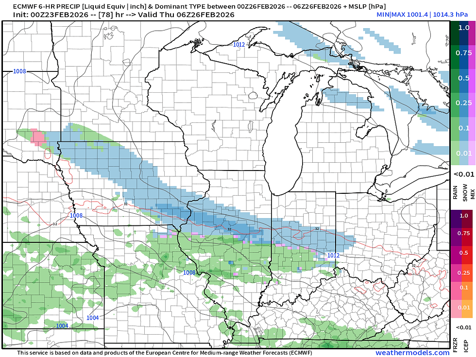
The Euro (above) is considerably less organized and produces quite a bit less snow with the late-week system. Compared to yesterday the trend is also farther south. This puts northeast Iowa out of most snow, and the Quad Cities region out of the heavier snow potential.

The GFS (above) is also weaker compared to what it looked like yesterday, but it still hits the area pretty good with a renewed layer of some snow. This also has a better placement for much of our area in eastern Iowa and northwest Illinois. Timing is still similar between the global models. It will all come down to those small details like the overall strength of the system.
MODEL BLEND

The RRFS

The EURO

The GFS

The overall spread in the models above covers about the gamut of solutions. The Euro is quite an outlier in terms of the placement and intensity of the snowfall. While I have quite the respect for the model's performance over the years, it is quite an outlier and therefore I am a little suspect. For what it's worth, the powerhouse blizzard in the Northeast was a rather rare win as of late for the GFS which had a much better skill days out.
The model blend, which takes and weight all of the American models available, honestly looks pretty good to me with a spread of 2-4" likely across the state of Iowa into northwest Illinois. Not enough to be a major impact, but again that timing with the Thursday morning commute is far from ideal. We'll watch it! It will be particularly interesting once the HRRR is in range to see how it compares to the similarly high-resolution RRFS.

Going back to the Euro, the operational run is even an outlier to its ensemble members. You can see the 50 members above have an average of about 1" of snow in the Quad Cities with a few members in the 3-5" range. Also, while we have this up, you can see in the longer range towards early March there is another system worth watching. There is quite a spread in possibilities with that second potential system as well, but there's a lot of time before we get there, so that's another story for another day.

Looking at temperatures, one the potential winter system departs, Friday looks like a very warm day in the region as strong southwesterly flow returns briefly. Temperatures should remain near to above normal headed into March!
Have a great week everyone!
-Meteorologist Nick Stewart


Comments