


DECEMBER'S TO REMEMBER...
- Nov 16, 2021
- 8 min read
MAY THE FORCES OF WEATHER BE WITH YOU...

DO, OR DO NOT, THERE IS NO TRY- "YODA"...PLEASE SUPPORT THE JEDI FORCE OF T.SWAILS 356 of you fine folks have made a voluntary $12 dollar donation to TSwails.com. I still need the support of 44 more of you to keep things going. Thanks to your generous donations to date, we are well on our way and with just a little more help we'll achieve our goal. All I'm asking is that if you enjoy the site and see value in it, please consider a voluntary subscription. I'm asking $12.00 dollars for a year. That's $1 dollar a month or 3 cents a blog if you consider the fact there were 450 posts issued over the past year. The site requires a significant commitment of time and resources and every donation, whatever the size is deeply appreciated. I just need a little help to cover the expenses. Click on the link below if you can assist or or need additional information. I thank you for your support and consideration.

TO BE OR NOT TO BE...A COLD DECEMBER?
I was looking at the CFSv2 temperature outlook for December and how it's changed since the onset of fall. It's been my contention since early October that December was going to be colder than normal with the potential for one or two very cold periods brought on by Arctic air intrusions. Maybe the CFSv2 is seeing such a trend. Look what it had for December temperatures back in October.

Now it has flipped to a much colder look.

Joe D'Aleo, a pioneer in the start up of the Weather Channel and one of the lead meteorologists at Weatherbell, has developed his own long range statistical climate model which includes a total of 24 inputs - major teleconnections and warm and cool pools in key locations. It shows the monthly breakdown of winter temperatures below. All are cold but December especially so.

Looking at the long range 500mb forecast off the EURO control for November 30th, I see the pattern in place that would throw the switch in favor of significant December cold. That horseshoe of red colors shows blocking across the top at high latitudes. Positive heights are forecast from the Pacific Northwest to Alaska and on into Greenland. That's how you set the table for harsh cold. There's always the chance the model backs down but the signal it's sending now is a cold one.

We've had some mean Decembers in years past but it's been at least 8 years since I can think of one that remotely measures up. I sent my eastern Iowa climate and folklore guru Steve Gottschalk on a mission to research our coldest December's. Steve has officially been observing weather for 60 years and is one of the longest tenured observer's in Iowa State history. He get's it right. Here's his findings along with some of his always interesting winter folklore.
Our Coldest Decembers
Iowa's weather records go back to 1873. I went through the archives and found the 10 coldest Decembers. Five of those 10 have occurred since 1963 with 4 of those occurring since 1983. Four of the other years were clustered around the time frame from 1909 to 1924. The only outlier was 1876. I am presenting a brief summary of each year in chronological order.
December of 1876
The state average temperature was 11.7 degrees with the coldest reading being around the 9th with a low of -23. Muscatine had 13.9" of snow for the month and Iowa City had 12.4". There was a blizzard on the 8th with temperatures from -15 to -20, violent N.W. winds and much drifting snow. There also was a terrible wind on the 15th. At Davenport the river closed on the 2nd, the men were crossing on the 4th and teams of horses were crossing on the 10th. There was steady cold all month.
December of 1909
The month was noted for low temperatures, excessive cloudiness and the frequency of snowstorms. It was the coldest since 1876. The average monthly temperature was 13.4 degrees with continuous cold from the 3rd to the 31st. The temperatures were as cold as a -26 in the N.W. part of the state. There was above normal precipitation with mostly snow after the 5th. A snowstorm on the 24th dropped 5" to 13" of snow with all freight trains and Christmas passenger traffic delayed. The thick coating of sleet on the 4th was was a good foundation for the snow that followed providing some excellent sleighing.
December of 1914
The average temperature for the month was 14.2 degrees. The 26th of the month was the coldest day since 1863. Iowa Falls dropped to -31. Some other low temperatures were a -23 at Clinton, -22 at Iowa City and -20 at Cedar Rapids. The coldest periods were from the 13-17th, 19-27th and 30-31st. The state snowfall average was 11.1" with Waterloo receiving the most 20.2".
December of 1917
The state average temperature was 13.3 degrees. The coldest reading was -40 at Washta on the 29th. Some other cold readings were -22 at Maquoketa, -21 at Iowa Falls and -19 at Clinton. The coldest periods were from the 6th-15th and the 27th-31st. The state's average snowfall was 6.7". The highest total was 17.0".
December of 1919
The state average temperature was 13.3 degrees. The coldest temperatures were a -31 at Iowa Falls. Grinnell and Belle Plaine both had lows of -25. The coldest readings were from the 1-5th, 8th-18th and the 31st. The state average snowfall was 5.8". Earlham had the most with 18.0". Cedar Rapids had 8.0". The snow cover from west-central to central Iowa was from 12" to 20" from the 9th to the 20th.
December of 1924
The state average temperature was 13.6 degrees. There was a protracted cold spell from the 16th to the end of the month. Washta had the coldest reading with -33 on the 28th. Some other cold readings were -27 at Iowa City, -25 at Belle Plaine and a -21 at Davenport. The state average snowfall was 8.1" with Alta having the greatest total of 21.0".
A destructive ice storm on the 4th from southwestern Iowa to the northeast part of the state produced up to 2" of ice. There were 27,000 telephone poles damaged with 200,000 miles of wires down from the storm. In some areas up to 42% of the fruit trees were damaged. It took 1,000 men to repair the damage and in the rural areas the phone service was out until the end of the month. The damage total was $750,000. The ice harvest began on the 20th of the month with the ice being 12" to 16" thick by month's end.
December of 1963
The state average temperature was 13.1 degrees. It was the coldest December in eastern Iowa since 1876. Some of the coldest readings were McGregor with a -32 (unofficial), -28 at Delaware, -27 at Waterloo and Clinton, -22 at Davenport and -20 at Cedar Rapids. There were recurring Arctic outbreaks during the month with 10 to 17 days with 0 degree readings. The coldest periods were from the 12th-24th and the 27th-31st. Some of the snowfall amounts were Cedar Rapids - 8.8" and Davenport - 8.0". There was a blizzard like storm on the 7th-8th. At mid-month the average snow cover was from 2" to 6". At month's end there was from 1 to 2 feet of frost in the ground.
December of 1983
It was the coldest December on record with a state average temperature of 7.6 degrees. The coldest weather was from the 6th-8th and the 16th-30th. The coldest reading was at Atlantic with a -33. Other lows were -26 at Waterloo, -25 at Lowden, -21 at Cedar Rapids and LeClaire. The greatest monthly snowfall was 24.0" at Columbus Junction. Some other totals were 16.3" at Lowden, 13.9" at Iowa City and 13.4" at Cedar Rapids. A blizzard with 50 mph+ winds, zero visibility in blowing snow and temperatures of -20 or colder shut down Christmas Eve across the state.
December of 1985
The state average temperature was 11.4 degrees. The coldest periods were from the 1-3rd, 6th, 11-21st and the 24th-30th. The coldest temperatures were a -32 at Grinnell, -30 at Belle Plaine, and a -21 at Cedar Rapids. The state's greatest monthly snowfall was 30.0" at Dorchester. Some other totals were 15.4" at Cedar Rapids, 14.5" at Waterloo and 13.0" at Muscatine. Cedar Rapid's snow cover ranged from 2" to 10" throughout the month.
December of 1989
The state's average temperature was 13.8 degrees. The coldest periods were from the 11th-24th and the 26th. The coldest reading in the state was -33 at Leon on the 24th. Some other colder readings were -27 at Anamosa, -26 at Belle Plaine, -22 at Cedar Rapids and -21 at Le Claire. The greatest monthly snowfall was 16.0" at Donnellson. Some other area amounts were 6.9" at Muscatine and 5.2" at Cedar Rapids. There was general snow cover from the 13th-27th.
December of 2000
The state average temperature was 10.0 degrees. The coldest weather was from the 11th-28th. Elkader had the lowest reading with -34 on the 25th. Some other colder readings were -27 at Anamosa, -26 at Vinton and -19 at Cedar Rapids. The greatest monthly snowfall was 41.5" at Waucoma. Some other totals were 30.8" at Lowden, 27.0" at Iowa City and 26.5" at Cedar Rapids. There was a general snow cover for most of the month. On the 31st Britt's snow depth was 40.0".
FRESH WINTER WEATHER FOLKLORE FROM STEVE
So far I have 15 woolly bear reports and they are predicting a normal to slightly colder than normal winter. The trees were later than usual in turning color this fall and were holding onto their leaves quite a bit longer than usual which usually indicates a colder winter. The Daylilies were blooming for a second time this season and were still blooming right up til the hard freeze. This also indicates a colder than normal winter. Also in that camp are the squirrels and rabbits who Steve notes have put on extra fat this season.
HOW MANY SNOWS THIS WINTER?
Steve also adds this past weekend he had enough wet snow to measure. Using the snowfall formula that includes the days since the new moon plus the date the first snow fell, should give us 22 measurable snows this winter. Time will tell. Thanks to Steve for all his research and detail...
A BRIEF BUT WELCOME WARM-UP
With all the cold the past few days and the talk of more in the distance, I am happy to report a short but welcome warm-up will surge into the area Tuesday. It reaches the SW half of my area faster so that area gets the best results with highs reaching the upper 50s. The rest of the region makes it to the low to mid 50s. Unfortunately, brisk south winds will take some of the starch out of the warming. Even so it will be a noticeably better day. These are projected highs on the EURO.

Throughout the area that produces readings that will end up 20 degrees warmer than what was seen Tuesday. The expected 24 hour temperature changes are shown below.

Late Tuesday night another fast moving cold front zips across the area putting an end to the warming just about the time it was getting established. With limited moisture the front will produce some passing clouds but little in the way of precipitation. There may be a few brief showers in the far south before daybreak Wednesday but the main impact of the front will be to bring cold air back into the Midwest. We go from being up 20 degrees Tuesday to being down 20 degrees by Thursday (as you can see below).

These are the actual highs the EURO shows Thursday. All but the far south holds in the mid to upper 30s.

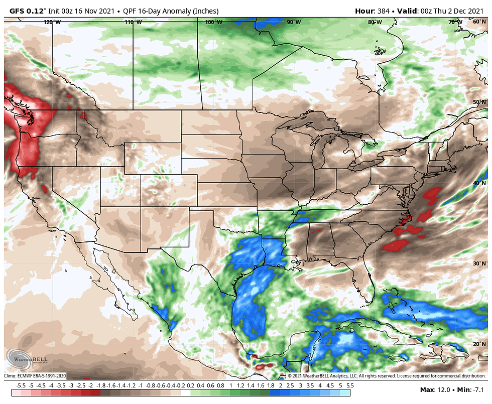
The progressive nature of the pattern means these significant swings in temperature will continue into next week as readings rise ahead of a couple more fronts and then fall with their passage. The fast movement of individual systems means moisture will be hard to tap and despite frequent rounds of forcing, precipitation looks minimal the next week across the northern half of the nation. In fact, I'm not seeing much potential for storms right up to Thanksgiving. Here's the 16 precipitation departures shown on the EURO.
Over the next 6 days (through Sunday) the EURO and GFS show this for rainfall totals. No snow to be found.
The EURO

The GFS

In a nutshell, outside of the ups and downs in temperatures through the weekend, there's not much exciting in the short term forecast. However, beyond Sunday I think the pattern will become much more interesting around Thanksgiving, especially if that key blocking I discussed at the start of this post links up from Alaska to Greenland. That's what I will be keeping my eye in going forward. I'll leave it for now. Thanks for your time and if you appreciate the site please consider a donation by clicking the link below. The future of TSwails is in your kind and caring hands. Roll weather...TS


Comments