


EL NINO THRIVES, WHAT ABOUT WINTER?
- Jul 9
- 7 min read
Now that we are in the heart of summer, and I'm confined to limited physical activity recovering from heart surgery, I spend a lot of time on my computer. One of the issues I focused heavily on today was the El Nino developing in the tropical Pacific. Most guidance forecasts it to reach the upper echelon of El Nino intensity by the time it peaks in late fall to early winter.
During El Niño events, tremendous amounts of heat are transferred from the Pacific ocean to the atmosphere of the Continental United States, elevating global average temperatures and increasing the likelihood of worldwide extreme weather events. Recent computer model projections have trended toward a more intense El Niño at its peak power compared to previous simulations, which indicates it has an even greater chance of causing global disruptions. It’s already being referred to as a Super El Niño, of which only a handful of events have reached that level of intensity in the last few decades, with the most recent one occurring in 2015/2016. Today's computer models are predicting this El Niño could be noteably stronger than any other event, going back to at least 1950. It's fair to say that, depending on [the] model, the forecasts are close to unprecedented.
SInce 1980, there have been four strong El Nino's measured that are plotted below. Since 2008, far more La Nina's (warm water in the tropical Pacific have been observed, as opposed to the colder water of an El Nino)). No chance that's going to happen this year.

In fact, the EURO projection, issued July 1st indicates that in the 3.4 region of the Pacific this Novermber or early December, could reach the strongest level on record with the plume of warm water nearly 3.5 degrees C. above normal.

At this point, the U.S. Climate Prediction Center indicates a 63 percent chance the El Nino reaches very strong strength (reaching an index of 2.0 C, or greater), and has issued an El Nino Advisory "warning of a potentially historic event".

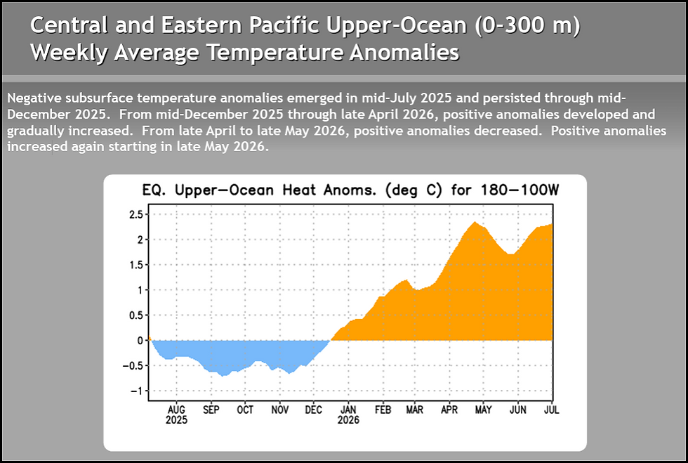
Since roughtly January of of this year, water temperatues in the central and eastern Pacific have gone from below normal to a peak recently of 2.25 degrees C above. We are well on the cusp of reaching Super El Nino status if strengthening continues as most models predict.
Already this year, the ONI (Oceanic Nino Index) is far more advanced than any previous El Nino since 1982.
In the Northern Hemisphere, El Nino's are well know to have their greatest overall impacts during the winter months. At that time of year, in its strongest state, split flow develops when the jet stream—a fast-flowing river of air that steers storms—divides into two separate branches. Instead of one main storm track moving across the middle of the country, one branch curves to the north and the other dips to the south, this lack of phasing is known as "split flow".
A "split flow" is one of the classic trademarks of a strong El Niño pattern, especially during the winter. Here is how it works:
The Northern Branch: The northern jet stream (polar jet) pushes north into Canada and the northern United States. More often than not, this keeps cold, Arctic air trapped far to the north, often leading to milder temperatures in the central and upper Midwest.
The Southern Branch: The southern jet stream (subtropical jet) dives far to the south. This branch is usually stronger than usual. It brings a conveyor belt of moisture that produces heavy storms, rain, and severe weather across the nation, typically aimed at the southern third of the country, especially California and the Southwest.
How El Niño affects the Central Midwest, in particular Iowa
What we know:
During an El Niño winter, the polar jet stream typically shifts farther north. Again, that tends to keep the coldest Arctic air locked in Canada instead of allowing it to plunge into the Upper Midwest and across Iowa and Illinois.
For our area, that usually means:
Milder-than-average winter temperatures
Fewer prolonged Arctic outbreaks
More winter precipitation falling as rain or sleet instead of snow
Below normal snowfall
When it comes to precipitation, there is a signal for below-average trends. Snowfall can (and will still occur during El Niño winters), but warmer temperatures often reduce snow accumulation and increase the frequency of rain or mixed precipitation events, especially across southern Iowa and much of northern Illinois.
Some recent strong El Nino's of 1.5 category or stronger
The winter of 2023-24 ( a moderate El Nino) produced a 2 week period of record breaking snow in early winter locally with heavy snow January 12th accumulating 7-14 inches in most area.


That storm combined with another January 9th, produced 25.5 inches of snow in 5 days in the Quad Cities. That is the snowiest 1 week period in the Quad Cities. Dubuque also claimed that honor with 24.7 inches. After that, the El Nino kicked in with a vengeance and the remainder of the winter received only an inch of snow. Temperatures were well above normal and and the snow bonanza was largely melted and relegated to piles in less than a weeks time.

Further north in Wisconsin, it was the warmest winter on record, averaging 31.8 degrees, more than 12 degrees above normal. Northern Wisconsin also experienced a historic snow drought, with seasonal snowfall totals running 20 to 60 inches below average.
1986-87 experienced a similar strength El Nino that had some early cold, especially bitter just before Christmas. During the week of December 18-25th, exceptional cold and wind produced record breaking lows as cold as 19 below in the Quad Cities. However, after that the remainder of winter, influenced by El Nino was significantly warmer than normal, with long stretches of above-average temperatures and very few days of extreme, prolonged cold. Much of the winter was spent in the 30s and 40s
Winter snowfall in 1986-87 came to only 11.4 inches at the Quad City Airport in Moline, the third least snowiest winter on record. Only 13 days recorded and inch of snow and most of those were in December. The dryness of the winter was exceptional with storms generally passing south of the area in a pronounced split flow. In Wisconsin, it was the driest winter on record!
In regards to this winter, the closest analog I can find in terms of sea surface temperatures in the tropical Pacific is 2015. Below you can see the SST comparison from that year in early July to this year 2026.

Similar conditions often produce similar results, and that is where comparable analogs like sea surface temperatures in July of 2015 to 2026 can can give us indications of what this winter might be like, especially if forecasts through December remain accurate. Here's what I found happened locally in the last super Nino winter of 2015-16 with the sea surface temperatures similar to now.
THE WINTER OF 2015-26
The winter of 2015-2016 in the Quad Cities was significantly warmer than usual, with temperatures 4 to 6 degrees above normal and snowfall 12 to 14 inches below average. An unusual severe weather outbreak brought notable tornadoes across the region December 23rd.
Winter 2015-2016 Breakdown
Temperatures: The season was notably mild, finishing 4 to 6° F above normal.
Snowfall: A very slow season for snow, with totals ending up about 12 to 14 inches below the historical average.
Notable Events: The season started with an active early winter storm on November 20-21, 2015, which brought 1 to 3 inches of snow to southern counties and 6 to 10 inches to northern areas.
Precipitation: Total winter precipitation was about 0.25 to 1 inch above average
Pre-Christmas severe weather.
A strong storm system moving toward the Great Lakes produced unsettled weather over much of the the Mississippi River Valley on Wednesday, Dec. 23 of 2015. Across eastern Iowa, western Illinois and northeast Missouri, temperatures warming into the mid 50s and lower 60s were about 20 degrees above normal. At Moline, IL, a high of 60 degrees toppled the previous record of 59 degrees set in th El Nino year of 1982. Elsewhere, high temperatures ranging from 64 degrees at Mount Pleasant to 50 degrees at Independence set the stage for severe weather. Weak tornadoes were reported near Good Hope and Taylor Ridge, while thunderstorms, torrential rain, strong winds, and small hail were reported from northeast Missouri to northwest Illinois. Preliminary rainfall amounts were generally less than an inch, with 0.69 inches at Davenport, 0.65 inches at Burlington, 0.41 inches at Cedar Rapids, 0.34 inches at Dubuque, and 0.80 inches near Freeport.
Interpreting the evidence
For the most part, the data suggests chances are significantly above average for a mild winter with above to well above average temperatures. Precipitation is harder to quantify with a few years seeing above average amounts. That said, most clustering comes in near to below normal. Snowfall, without access to regular cold air due to the split and northward placement of the northern jet, is just as likely to be rain as it is as snow. The odds point to below, to at best average snowfall amounts.
One thing I have noted over the years is that the full force of El Nino's tends to be be felt near or after Christmas. That's where El Nino gets it's name "Christ Child". October and November tend to be cooler than normal, with some years quite cold with some snow in both months. That can carry over into parts of December but as the El Nino matures, cold is less likely along with snow from late December into the spring. I think some version of that scenario is likely for us this year.
Before I sign off, (for those wondering), I am continuing to recover from my health issues the past 4 months. The last week has been a good on, no set-backs, slow but sure improvement of my shortness of breath, strength, and appetite. I bought blue jeans today. I had lost so much weight (30 pounds) that my old ones fell down to my knees (even with a belt). A stylish look to be sure! My motto now is get busy living instead of dying. I have a sign on the refrigerator to that effect reminding me to eat with a passion and purpose. I will be back to weather as soon as my strength allows it. Just know, I haven't forgotten my love for weather and the many of you who find my insights worth reading. Thanks again for the support and inspiration. Roll weather...TS


thanks for the info and look into the future .
Praying for a Great recovery, maybe not as fast as you like but better than you expect!!! I look forward to many more weather updates from you!!! Miss seeing you at the Mississippi Valley Fair every year...