ENOUGH, IS ENOUGH...
- Apr 3, 2024
- 4 min read
IF IT AIN'T ONE THING, IT'S ANOTHER
Well, here we are with the wind howling, snowflakes swirling, and wind chills hovering around 20. It's beginning to look a lot like Christmas! Too bad it's April 3rd. It goes to figure that after a record warm winter, it wouldn't give up without a fight. So, as we await better days ahead, the rest of this week looks less than "springlike", although some slow improvement is expected by the weekend. Enough is enough...
TERRY'S 5-STAR AIRBNB, WHERE VACATIONS ARE HEAVENLY (MAKE IT YOURS)
TSWAILS.COM, THE GUY DOES WEATHER RIGHT
THAT WAS SOME STORM...
The past 24 hours, a strong southern stream storm loaded with moisture locked hands with a stout shot of late season cold delivered by the polar jet. The result was a rapidly deepening low pressure, which Tuesday evening was measured at 29.15 inches over southern Lake Michigan. The energy driving the ferocious system looks like this at 500mb. That's a very impressive trough!

Rapid pressure rises behind the deep low has caused wind gusts of more than 40 mph from the N/NW. The storm center was so concentrated that, much like a hurricane, it developed an "eye" like center. It's readily visible on the GOES Satellite image taken around 2:00pm Tuesday approaching Chicago.

Here's another view of it. Look at the eye emerge over southern Lake Michigan. You can see the moisture surging northward into the center on the eastern flank and the cold air on the backside diving into Minnesota. That is classic stuff.

With the circulation center at 500mb moving very little today, wrap around clouds and moisture will continue to fan the region. That's resulted in snow showers increasing overnight that will continue off and on much of the morning, perhaps into the afternoon in spots. While accumulations will be minimal, and mainly on elevated surfaces such as grass, there may be times when temperatures are cold enough and snow falls hard enough to accumulate on some roads, especially bridges and overpasses. Some slick spots are likely in places, and the NWS has a winter weather advisory in place until 10:00am for the area north of I-80.

Including what snow falls overnight, here's what models continue to suggest snow totals before it all comes to an end. That's after some parts of my area saw as much as 3 inches of snow Tuesday when rain turned to a brief period of heavy wet snow. When it's all said and done, new total snow accumulations in most spots will end up in the 1-3 inch range, heaviest north. A few locations could hit the 4-inch mark. It will be hard to measure, as melting from below and above may offset the depths models are indicating. One good thing about snow in April.
The EURO

The GFS

The HRRR

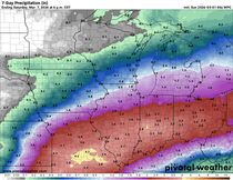
One of the positive impacts of this storm is that rain has fallen multiple times since it began Friday night. This has certainly alleviated some, if not all, of the dry conditions that were prevalent for many. However, this last event under-produced once again further west in parts of central and northern Iowa. Below you can see 7 day rainfall totals ending Tuesday morning.

Beyond that, you can see additional totals from the final phase of the storm Monday night through Tuesday.

Steve Gottschalk of Lowden, Iowa reports precipitation totals on Tuesday alone of 2.66 inches. (3 inches of that came as snow), giving him 50 inches for the winter. Pretty good! He also broke his daily rainfall record for April 2nd by an inch and a half. Iowa City also picked up 2.25 inches Tuesday, with 2.00 inches in Dubuque. The track was perfect for heavy snow over the NW half of my area. Fortunately, there was just enough warm air to keep the bulk of it rain, or some massive snow totals would have occurred like we saw in early January. These are some preliminary snow amounts through 2:00am Tuesday night from the Iowa Mesonet.

As I mentioned, Wednesday is just going to be a lame day with snow showers and wind driven cold. Highs will be at least 20 degrees below normal, in the range of 34–38 degrees from north to south. Wind chills much of the day will range from the upper teens to mid 20s. Ugh.

With the huge 500mb trough associated with our storm barely creeping east the next few days, below normal temperatures are in our future through Saturday, maybe even Sunday. The EURO keeps highs in the 40s Thursday and Friday, with 50s Saturday and Sunday. After the snow showers end Wednesday, skies are likely to remain cloudy through Thursday, with the cyclonic circulation rotating deep moisture and cold unstable air into the Midwest. It does look dry until Sunday, when a chance of showers creeps back into the forecast. If the EURO is on the mark, a more springlike pattern settles in for a good portion of next week. Here's hoping!

With that, I bow to this impressive storm that that will take a couple more days to huff and puff itself out. Roll weather...TS


Comments