

EUREKA, THE PATTERN CHANGE?
All week long I've been speculating on several teleconnections that heading into late October typically signify colder weather in the 6-10 day period here in the Midwest. Before that, It's long been established that we've got another week of unseasonal warmth ahead. So warm, that this October is likely to end up in the top 5 warmest of all time locally. The trend is evident on the EURO's meteogram for the Quad Cities which keeps highs in the upper 60s to mid 70s through the end of the month, a good 10 to 15 degrees above normal.

They say, all good things must come to an end and as you can see above, the EURO is aggressive with the first signs of the change to colder weather around November 2nd, slightly later than yesterday. Additionally, the EURO is even colder than 24 hours ago with a couple of days stuck in the 40s. The 46 shown November 3rd would be 30 degrees colder than what's indicated October 30th.
At 500mb on the EURO, you can see the alteration in the upper air jet stream pattern October 30th to November 8th that delivers the change.

While teleconnections support the chill of the EURO, one model run is not enough to say it's a slam dunk. Compare the GFS 500mb flow November 8th, to the EURO for the same day below.
The GFS November 8th

The EURO November 8th.

The difference is night and day, a radical difference between the warmth of the GFS and the colder look of the EURO.
That puts me in a quandry. I was expecting the colder look of the EURO based on a recurving typhoon, a strong negative EPO, and an Arctic Oscillation that is trending slightly negative. Those 3 teleconnections are strong signals of colder weather November 1st. Yet, we have the GFS quickly reverting to its warm ways after a few days of cooler conditions. Compare temperartures on the GFS below to the EURO shown at the top.
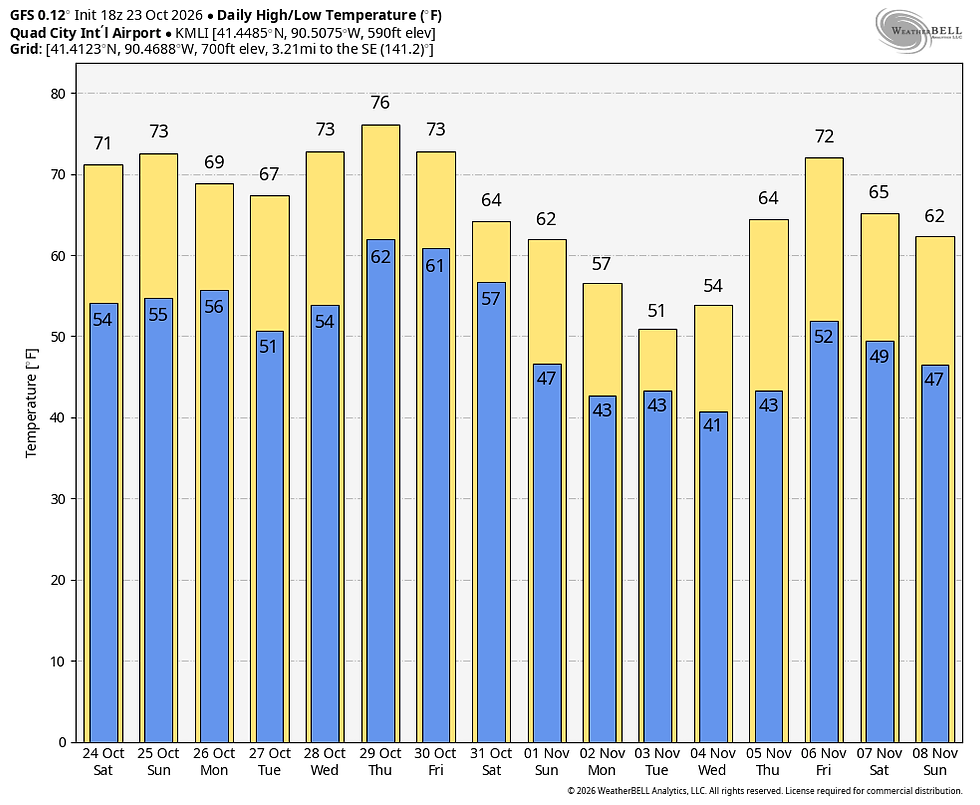
Dissecting the two solutions, I see a strong trend for cooler weather on both models November 1st through the 4th that demonsrates resonable confidence. After that, the GFS goes an entirely different direction. My gut tells me the cooler EURO (or a slightly warmer version of it) is a more likely scenario. Unfortunately, the true answer is blowing in the wind and will take some time to reach us.
Whatever happens, the atmosphere is becoming more energetic and that usually means chaos in the mass fields of model guidance until the pattern change is resolved one way or the other. Rest assured, cooler weather is simmering in about a week, the question remains how cool and how long does it last? Meantime, enjoy the relative warmth of the weekend. It's a gift to be sure, especially with the fall colors coming on fast. Roll weather...TS


Comments