

STILL RIDING THAT HORSE...
Before I get into the meat of this post, I wanted to take a few moments to say thanks for the outpouring of support regarding the passing of my my furbaby Emma Rose. My tribute to her generated over 27,200 responses from around the Midwest! That tells me that many of you have experienced a similar loss and know full well the gravity and emptiness that comes with the experience.
In fact, many of you (by way of your own stories) sighted hope, love, faith, deeply held memories, and time as the as the light to follow moving forward. By your own admission, the loss of unconditional love is a hole that time may never fully fill. However, our pets would want the happiness they brought to each of us to live on in their wake. I certainly owe it to Emma for her 17 years of companionship. I've now committed her to my heart and memory where I can feel her whenever I want. That is a special gift.
I also owe all of you a huge thank you for you compassion and sympathy. I am so touched by all the personal notes of strength and understanding tied to the passage of someone so beloved. Your insights and efforts to sooth the pain are deeply appreciated. The beautiful sunset this evening is proof that better days are ahead.

STILL RIDING THAT HORSE...
What can you say about the weather recently other than wow! Everybody was in the 70s Wednesday with Sioux City checking in at 81 degrees, tops in Iowa. Outside of 2 days last week, this exceptional stretch of weather goes all the way back to September. 37 of the past 51 days, highs have been at least 70 degrees or warmer in the Quad Cities. Only 2 of those 51 days have remained in in the 50s with nothing worse than a 56.

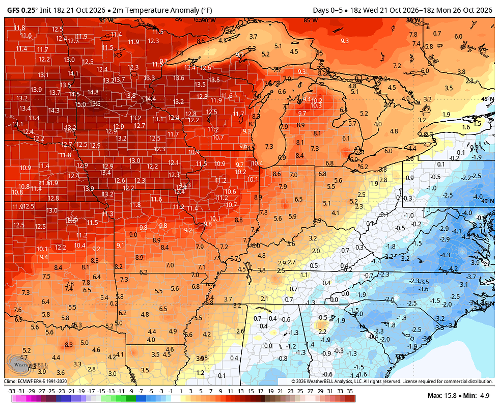
Looking at the short term pattern I see at least 4 more days with highs in the 70s through Sunday. We haven't seen a run like that in many moons, if at all! The average temperature departures the next 5 days on the GFS look like this. Most of the region averages 10-12 degrees above normal through next Monday.
Not only that, precipitation is non-existant through next Monday. The GFS shows this for total rainfall through the period Thursday into Monday. All the action remains north and west closer to the storm track.

With November little more than a week away, the question becomes how long can we keep this up? Two teleconnections have me thinking a change to colder weather is due sometime near or after the 27th of October. One feature to keep an eye on is typhoon Champi that is expected to track through the western Pacific. If it passes east of mainland China (shown below), the remnant energy should enter the Bearing Sea and reintensify. The rule of thumb is that in 6-10 days it will buckle the upper level jet over the Gulf of Alaska changing the trajectory of our air masses allowing colder air to find a pathway into the Midwest late October or early November.

Additionally, the EPO (eastern Pacific Oscillation) is signalling the potential flip turning strongly negative by October 28th.

Below you can see what the negative phase of the EPO looks like. Note the ridge off the west coast and the associated buckle at 500mb that drives colder air masses into the heartland. The correlation of the two teleconnections discussed implies colder weather ahead in roughly 6-10 days.

Today the deterministic models are starting to sniff the potential with the GFS indicating a 500mb jet that looks like this in early November. That is a far different look than what we are currently seeing and fits what the teleconnections are indicating.

Helping solidify the point is the meteograms of the GFS and EURO showing temperature trends the next 2 weeks. Notice how a couple different fronts carve out progressively colder tempeatures in the long range.
The GFS

The EURO

What I want to stress is that the timing and depth of the cold air is far from exact at this distance so the takeaway is the idea of the trend and a pattern change. Modeling will become more accurate in approximately 5-6 days on the relevance of any cold air locally.
Just for fun, the GFS does signify the potential for some snow just to our northwest a few days into November. This is far from a hard trend and confidence of where any snow would fall in the Midwest is low at this distance. I just like looking at a chart indicating snow, low confidence or not. More important to us is the fact that if the model is showing snow, it is seeing a much colder air mass.

Well then, despite several more days of delicious weather in the days ahead, some things are cooking in the longer range worth watching. More on that in coming posts. Until next time, we're still riding that horse with the pretty warm colors. Roll weather...TS


Comments