


EXTREME, AND IT'S NOT WINTER
- Dec 9, 2025
- 6 min read
Considering the official start of winter is still more than two weeks away, it's impossible to say how 2025-26 will end up in terms of severity. However, you have to admit that 2025-26 has gotten off to a fast and rather harsh start, with many places already measuring more than half their average winter snowfall in a week's time. Not only that, sub-zero lows of 5 to 15 below have been good enough to set records. In Cedar Rapids, the minus 11 last week was the earliest double-digit below zero temperature since 1891.
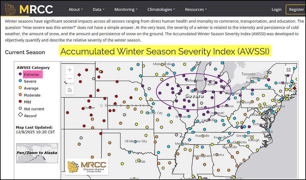
If you are wondering how this measures up, one place to get some perspective is with the Accumulated Winter Weather Severity Index. The (AWSSI) was developed to objectively quantify and describe the relative severity of the winter season. The index measures the persistence of cold weather, the amount of snow, and the amount and persistence of snow on the ground. Based on a formula, it quantifies on a running basis how this winter ranks. The AWSSI is calculated for each season from 1950‐1951 to the current season.
Defining the AWSSI Season
The AWSSI is not limited to meteorological winter (December ‐ February) but is intended to capture winter weather from its earliest occurrence to its last.
The winter season begins with the first occurrence of any one of the following:
First measurable snowfall greater than or equal to 0.1 inch.
Maximum temperature less than or equal to 32°F.
Winter season begins on December 1 if conditions above have not been observed.
The winter season ends with the last occurrence of any one of the following:
Last measurable snowfall greater than or equal to 0.1 inch.
Last day with 1 inch of snow on the ground.
Last day with max temperature less than or equal to 32°F.
Winter season ends February 28/29 if the above conditions have occurred.
Daily scores are accumulated through the winter, allowing a running total of winter severity in the midst of a winter. 5 different classifications are assigned, ranging from mild to extreme.

To no one's surprise, this year is currently ranked as a W5, (simply categorized), that means it meets extreme winter standards.
All the Midwest locations measured from eastern Iowa through northern Illinois and southern Wisconsin are in the extreme classification. Dubuque, representing my northern counties is currently assigned a 148 ranking.

Representing my central counties, the Quad Cities comes in at 110

Burlington in the south is only at 89, but that's still good enough for an extreme ranking.

Snowfall the last 10 days is a big driver in the calculations.

However, so are temperatures, which the past 10 days have produced departures that look like this. The last time we had a high temperature above freezing in Dubuque was November 26th (12 consecutive days)!

GIVE THE GIFT OF MY 5 STAR AIRBNB IN GALENA

Holiday and winter specials are now in effect through March. Let us help you set up a personalized gift certificate that's sure to create a lifetime of memories! Santa Claus approved. Call or text Carolyn at 563-676-3320 for details and our very best pricing. https://www.littlewhitechurchgalena.com/
A SHORT RESPITE...
The area will get a short respite Tuesday and Tuesday night, with temperatures expected to slip above freezing thanks to a vigorous clipper that tracks across SW Wisconsin Tuesday night. Its surface features and precipitation shield looks like this at midnight Tuesday.

Of all the recent clippers, this one is the strongest the Midwest will have experienced since this pattern change was introduced around Thanksgiving. Where this system differs from the rest is that it has the strongest dynamics, featuring a 150kt jet streak, a surface low under 990mb, and ample moisture from an ongoing atmospheric river event originating over the Pacific.
More important, the track of the low pressure will be just far enough north to place my region in the warm sector Tuesday afternoon and the majority of Tuesday night. This keeps the heavy snow threat further north in Minnesota and Wisconsin. Here's what the GFS shows for snow through Wednesday.

Despite a healthy snow cover, temperatures are expected to reach 32 north to 37 south by Tuesday evening, with brisk SW winds developing. Temperatures will slowly climb Tuesday night, reaching the day's highest levels of 38 north to 43 after midnight.

Being on the southern flank of the clipper, the dry slot will be a player and precipitation with the first phase of the storm should be light locally and confined mainly to my northern counties. There is a chance of some mixed precipitation late Tuesday afternoon near HWY 20 that initially could include a brief period of freezing rain. If it develops, it should not last long, switching to light rain or drizzle as the warmer air inches northward in the evening. Still, it could generate a glaze that causes travel issues in my northern counties.
The most impactful aspect of the storm is sure to be the winds. Just to the SW of the circulation, very strong winds are anticipated as dry air from the "dry slot" sinks, pulling strong upper level winds down to the surface. Known as a stinger jet, this feature should drive NW wind gusts of 35-50 mph late Tuesday night and early Wednesday. Tapping colder air, temperatures by mid-Wednesday morning will return to sub-freezing levels in the 20s. A wind advisory is anticipated for many areas when the NWS decides to concede to the threat.
One big question that remains unanswered is how will the winds affect the remaining snow cover, especially across the north, where it's several inches deeper than in the south. Most likely, a crust will form on its surface Tuesday due to above freezing temperatures and some light precipitation. However, the strength of the winds could break up and overwhelm the crust and generate areas of blowing and drifting snow. This threat is most likely in my NW counties, from Cedar Rapids to Dubuque. Worst case scenario, if the crust breaks or fails to develop, reduced visibility due to blowing and drifting snow could develop by Wednesday morning.
Adding to that concern, is the fact that snow showers are expected across the north Wednesday morning. These could produce brief periods of intense snow and reduced visibilities, especially with the added factor of high winds. Total accumulations of 1/2 to 1 inch are a possibility north of HWY 30, and are most likely to occur closer to HWY 20.
A Winter Storm Watch is currently in effect for parts of NW and NC Iowa, where near blizzard conditions are possible if the surface crust of the deep snow pack is broken. By morning, these advisories could be altered as conditions evolve. If you are traveling into NC Iowa up into Minnesota and WC Wisconsin, travel could become very difficult by Tuesday evening. Check the latest road and weather conditions before departing.

BACK TO COLD AND ADDITIONAL CLIPPERS
After the system departs Wednesday, NW flow strengthens enough to bring colder weather back to the Midwest. Below normal temperatures return, but the worst of the cold holds off until Friday night and the weekend, when true Arctic air surges south on strong winds. The Arctic front should be preceded by some snow Friday and possibly again Saturday as a couple more disturbances whip through the long wave pattern. Some light accumulations appear possible, more on the order of 1–2 inches. That will become clearer in a couple of days
Meantime, the weekend cold appears formidable. The EURO has highs Saturday in the single digits and Sunday is even worse with max. temps below zero over much of the area. Lows Sunday morning are shown 12-16 below zero in locations with the deepest snow cover.

For perspective, these projected temperatures early Sunday are 38 to 42 degrees below normal!

Wind chills of 25 to 38 below are also on the table Sunday morning, according to the EURO.

These are the actual sub-zero highs the EURO indicates Sunday afternoon, again some areas are as much as 40 degrees below normal.

Needless to say, there is a ton of weather on the table through the weekend. It should keep me more than busy. That's where I will call it tonight. Roll weather...TS.
TSWAILS.COM expert weather consulting services (CLICK FOR MORE)

Private consulting
Legal forensic services as an expert witness
Public speaking engagements for groups or individuals
Post storm analysis
A private day-long weather school class
Specialized events forecasts
Severe weather seminars
Lectures and training
Climatological services
Meteorological workshops.


Extreme weather no longer waits for a season, and decisions still have to be made before the first alert hits a phone. Snow Day Predictor Canada fits into this reality by offering AI-driven, probability-based snow day and school closure forecasts tailored to Canadian locations. Instead of reacting at the last minute, parents, students, educators, and workers can use early insight to plan schedules, childcare, and commutes with more confidence. In a weather-based decision support space where timing matters as much as accuracy, this platform turns uncertain forecasts into practical, forward-looking guidance.