


FIRE IN THE HOLE...
- Nov 4, 2025
- 5 min read
It's been a long fall for a weathehead like me, one who enjoys the excitement of storms and the challenges they bring. The last 2 1/2 months have been about as slow as it gets, with an endless slew of dry, mild days. Most of you are going, hey Swails, what's the problem, we like this kind of weather? I respect that, but I'm just not wired that way, and I've come to the conclusion that's never going to change. Anyway, I'm in a pretty good mood tonight as I see some fire in the hole and I think winter is waking up and by Thanksgiving, we'll be living with the reality It's coming out of hibernation.
The way I see it, this is going to be a process that takes a bit of time with some initial wake up attempts followed by a few naps, but if what I'm seeing plays out, there should be a snap in 3 weeks that puts fall away for good. The EURO meteogram shows a couple of those wake-up attempts in the next 2 weeks, one later this weekend and the other the end of the 14-day period. But as you can see, fall won't go down easy with two nice stretches in the mix.

As you can easily see in the meteogram above, the next few days through Friday, it's more of the same with breezy mild days and crisp nights, Indian Summer for sure. Outside a few showers on a weak front Thursday night, most areas as a whole stay dry through at least midday Saturday. Things get more interesting later Saturday as a wave moves southeast along the stalled front aligned along the southern Iowa border. You can see the energy digging into Nebraska Saturday morning at 500mb.

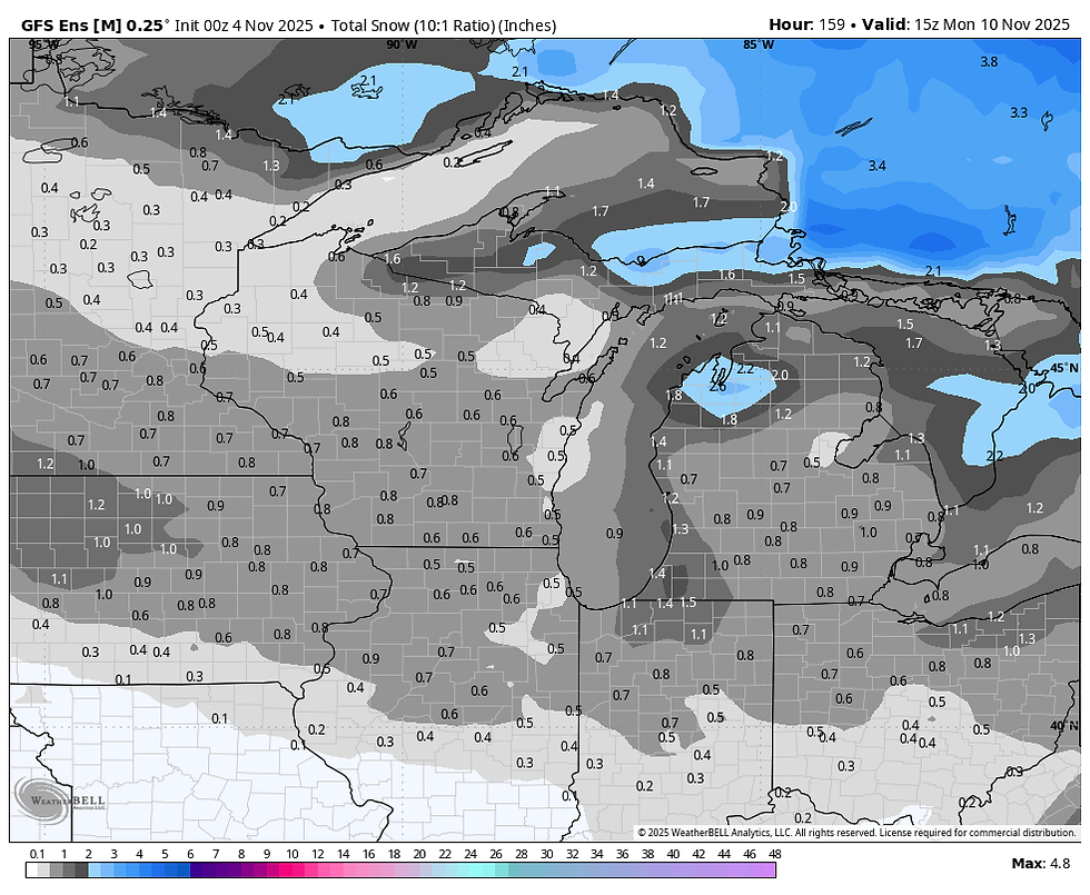
The wildcard then becomes where does the surface low develop and track from there. As is often the case, the EURO and GFS disagree on the track, which makes a difference in the sense both models indicate the potential for a band of snow north of where the surface low passes. The EURO takes the center close to the Quad Cities and on to Chicago. However, it has a warmer thermal profile and produces more rain than snow.

With that track it dumps its snow primarily over central Wisconsin.

The GFS on the other hand takes the surface over the SE tip of Iowa into EC Illinois.

The more southerly track along with colder thermal profiles sets up a snow band that's heaviest from roughly I-80 north, including much of my area.

My feeling is that the early season nature of the event, along with the limited cold air in place initially, favors a more northerly track, keeping rain the predominate precipitation type in my area until the final stages of precipitation. The event is still over 4 days away, so things will evolve and change some. Despite the GFS being consistently further south on the track and colder the last 48 hours, I suspect it will shift further north in future runs. That said, it's not yet a certainty yet as the ultimate degree of phasing could alter the track of models north ot south .
Looking at ensembles (a forecast average comprised of numerous members of a model), we see this. You will notice the EURO ensembles are fairly consistent with the deterministic run above. That means pretty good consistency in all the solutions, less outliers.

The GFS ensembles are further north and lighter compared to the deterministic run, which is a red flag leading to less confidence in its solution.
Just for fun, I added the Canadian ensembles, which actually are the furthest south and most bullish with snow accumulations. We still have some issues to iron out but have plenty of time to get the job done.

In the end, I do think there is a decent chance the north at least gets in on some wrap around snow showers later Saturday night or Sunday. If nothing else, we will see rain starting at some point Saturday afternoon that continues Saturday night before possibly changing to snow in the north before ending.
Models are suggesting this for precipitation totals.
The EURO

The GFS

The Canadian GEM

One aspect of the system that has reasonably high confidence is the cold air that follows the storm will be the coldest of the season so far. Wind chills Monday morning will be in the low to mid teens with actual air temperatures in the low to mid 20s.

The EURO indicates 850 temperatures of -11 C. late Sunday. That is cold stuff and this will be an eye-opener if models verify. In fact, I would think air that cold aloft would at least lead to scattered snow showers or flurries Sunday night or Monday as it passes.

Fortunately, this is just a short wake-up call, as the chill shifts east Tuesday and another nice warm-up ensues the middle and end of next week.
VISIT US AT MY 5-STAR GALENA AIRBNB.

My 5-STAR AIRBNB just outside of Galena is a premier Midwest destination and a guest favorite! We take pride in our perfect rating, amenities and cleanliness. Take advantage of our fall and winter specials and instantly save $200. Book directly with us and eliminate AIRBNB fees and additional costs that will save you cash. Other discounts apply. Call or text Carolyn at 563-676-3320 for our best deals of late fall and early winter. See more at https://www.littlewhitechurchgalena.com/
FIRE IN THE HOLE...
Getting back to my initial thoughts that this weekend storm being just a warm-up act, here is the snow cover around North America today. Lame.

By the 18th of November, the EURO ensemble means show this much snow falling.

By the 19th of December, the EURO ensemble mean shows this much falling

The control of the ensemble mean has this by December 19th.

Once again for perspective, below is the amount of snow the EURO ensemble means shows over the next 6 weeks, much of this after November 18th. Let me make this perfectly clear, I am not one of these guys that throws out great model runs to get attention. The value in this is not the snow amounts because they are going to change daily, most likely ending up lighter. What is significant is that the model is seeing a very active pattern that involves cold and snow around Thanksgiving and beyond. As I say, there is a decent chance snow amounts end up substantially less. That said, what really stands out to me is the vast snow pack that is shown existing from Arkansas northward to the North Pole. Canada is buried. Going into winter, such extensive snow cover would keep air masses descending from Canada much colder than they would otherwise be passing over bare ground. The potential would be there for some big time cold air intrusions.

The model is sensing that as it should, showing 30 day "daily" temperature departures from November 17th through the 18th of December that are well below average.

Even more impressive are the 7 day departures for the period December 12th through the 19th. Those would not be pleasant.

I will spare you the teleconnections, but they are supportive of a wintry end to November that carries well into December. I've been wrong before, and maybe I will be again, but there are some very impressive trends indicating winter may get off to a fast start. Enough so that, I am bringing my case to the forefront. Fire in the hole. Roll weather...TS.


Comments