


FROST ON THE PUMPKINS
- Oct 23, 2025
- 4 min read

That frisky storm system that's buffeted the Midwest with 3 days of high winds is finally pulling off to the northeast. In doing so, the tight pressure gradient it created is relaxing, allowing winds to decouple. That's going to make experiencing the outdoors a far more comfortable proposition the next few days. However, the price to pay will be a couple of cold frosty nights and in some areas, it will mark the end of this year's growing season. The NWS has upgraded the northern third of my area to a Freeze Warning until 9:00am Wednesday. Several hours of temperatures at or below freezing are anticipated. The general range should be 29-32.

Further south, a Frost Advisory is in place for the remainder of my area, where readings of 32 to 35 are anticipated. While this should generate plenty of frost, most vegetation should not be impacted. For the region as a whole, Thursday will start with the coldest readings of fall so far.
On average going back to 1893, Cedar Rapids sees its first fall temperature of 32 or below October 9th making this year a couple of weeks behind schedule. The earliest 32 in Cedar Rapids was September 15th in both 2007 and 2011. The latest date is November 7th, 1900.

Here is the date of the earliest fall freeze for some selected cities in my area.

Below, the date of the latest fall freeze.

Temperatures Thursday will warm slowly but steadily after sunrise. During peak heating in the afternoon, most spots will range from 50 to 55 degrees. Winds will be far more tolerable at 10-15, along with plentiful sunshine. Overall, a pretty good day.
Thursday night, the ridge axis will be directly overhead, ensuring clear skies and light winds. The dry air will rapidly cool after sunset, and it looks as if most areas will see lows of 28-32. If you missed out on a freezing temperature Wednesday night, you will likely see one Thursday night. I expect widespread freeze warnings will be issued by the NWS.
Friday through Sunday, the area should remain just to the north of a slow moving system that inches across the southern Plains and mid-Mississippi River Valley. While this should produced mixed sun and clouds locally, aside of a brief shower or sprinkle Saturday night, we continue on with largely dry weather. Highs will generally remain in the mid to upper 50s. If any select spot can squeeze out a little more sun than is currently expected, a few places could hit 60.
VISIT US AT MY 5-STAR GALENA AIRBNB.

My 5-STAR AIRBNB just outside of Galena is a premier Midwest destination and a guest favorite! We take pride in our perfect rating, amenities and cleanliness. Take advantage of our fall and winter specials and instantly save $200. Book directly with us and eliminate AIRBNB fees and additional costs that will save you cash. Other discounts apply. Call or text Carolyn at 563-676-3320 for our best deal of summer. See more at https://www.littlewhitechurchgalena.com/
A VISIT FROM JACK FROST...
Early next week has been advertised regularly as a period where a significant storm system was possible. Models today have thrown a wrench in what happens by indicating far less phasing between the northern and southern branches of the jet. Two days ago the EURO showed this very impressive upper air low wrapping up over the Midwest with a cold rain by the 28th or29th.

Now the GFS and EURO have more of a clipper type disturbance tracking southeast. Now, the EURO 500mb jet looks like this compared to the last frame of the animation above. Certainly a much quicker and weaker solution.

Even so, some rain remains on the table, despite the fact that at the very least amounts have been cut in half from previous model runs. We are still 5–6 days from the core of what develops and changes could still alter the intensity, track, and amounts of rainfall. As a result, I am showing what the numerous members of the ensembles of the EURO and GFS are indicating for total precipitation Monday through Wednesday night. Stay tuned.
The EURO ensembles

The GFS ensembles

Temperatures next week will likely start out fairly mild and seasonal ahead of the system. After its passage, a healthy shot of cold air is still expected towards the middle of next week.
I will say in passing that the ensembles of the EURO and GFS both have at least snow showers impacting some part of the area the first week of November. A sign that temperatures by then have the potential to be significantly colder, but of course that's contingent on the models being right.
The EURO ensemble mean

The GFS ensemble mean

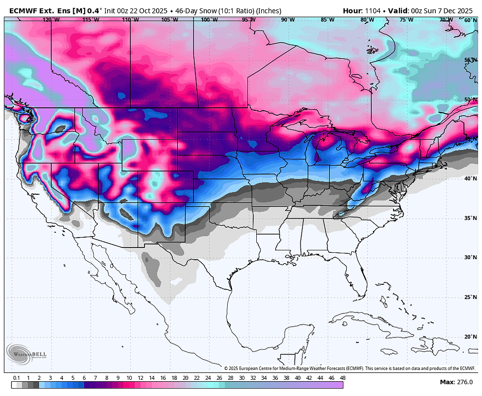
The ensemble mean of the weeklies out through December 7th have a rather wintry look, showing snow as far south as Arkansas, northern Mississippi and Alabama. Just some food for thought, far from a sure thing.
On that note, I will wrap this up. Have an excellent day and if you enjoy the site, please hit the Facebook like button. Roll weather...TS


Microsoft Dynamics AX Support is here to help businesses get the most out of their ERP systems, whether you’re using older versions like Dynamics AX 2009 or AX 2012. Think of it as a reliable partner that helps you keep your system running smoothly, solve issues quickly, and make sure everything stays aligned with your business goals.
If you’re still on an older version or considering an upgrade to Dynamics 365, having the right support makes all the difference. From fixing performance hiccups to installing important updates, AX Support teams know the ins and outs of the system and can guide you every step of the way. Planning a move to Dynamics 365? We’ll help you prepare, migrate, and settle…