


GOING DOWNHILL REALLY FAST...
- Feb 14, 2023
- 4 min read

Hi friends, let me start by thanking the 221 of you who made a voluntary donation to my site. Your yearly investment is critical in helping me meet my operating expenses. It's a good start, but for me to continue on, invest the effort and time that I put into my product, I'm going to need a little more help to reach my goal..
As much as I enjoy my work, it's a major investment of time that ties me down every day of the year. My hope is that you all agree it is a first rate product that involves a great deal of thought and passion. Day in and day out, you can trust the source knowing it's as accurate as any weather forecast can be. I make no bones about it, I want to be the best.
To do that, just like any other non for profit organization, I have to go to you the people to ask for support. Whatever you can do to keep this train rolling, it is immensely appreciated. You have my word you will get a 100% return on your investment. CLICK HERE TO DONATE
BYE BYE NICE WEATHER....
Sensational "springlike" weather was in place around the central Midwest Monday with sunny skies and well above normal temperatures. With snow covered ground, my northern counties remained in the low 40s while the area from roughly I-80 south was in the range of 50-55 degrees. That sun is getting stronger! Below in white, you can see the snow covered terrain of the upper Midwest.

Clouds are rapidly expanding to the southwest Monday night as an energetic pattern unfolds that will bring two significant systems into the Midwest over the next three days.

The first takes a track through western Iowa which places my area in the storms warm sector. Temperatures will again hit the 50s in the south while holding in the mid 40s across the far north. With a tightening pressure gradient strong south winds will steadily increase Tuesday reaching 20-30 mph sustained. Some gusts may go over 40 mph and a wind advisory has been posted by the NWS for much of the south. This could be extened further north in the next 12 hours if conditions warrant.

The gusty winds will draw moisture and clouds northward. Available water vapor approaches an inch in SE Iowa Monday afternoon, over twice the normal levels.

What should keep rain totals light to moderate (1/4 to at most 1/2 inch), is the speed and track of the surface low which is out to the west. We'll get a good slug of forcing for showers (maybe an isolated t/storm) during the afternoon and then a dry slot invades cutting off moisture and limiting any precipitation to spotty showers or drizzle by late day in the south and early evening in the north. As a cold front arrives Tuesday eveing a narrow band a fast moving showers could pop up along it, mainly east of the Mississippi. Here's what the GFS and EURO are indicating for rainfall totals from this initial event.
The GFS

The EURO

BACK TO WINTER THURSDAY
With time, Tuesday night's cold front pulls up stationary in SW Missouri and central Illinois near St. Louis Wednesday. That allows northerly winds to take hold and colder air to deepen. The front and its thermal boundary shows up nicely late Wednesday running from Springfield Missouri to St. Louis and on to Indianapolis. North of it readings in NW Iowa are in the teens with the cold air oozing southeast towards my area.

Come Thursday morning the baroclinic boundary remains in place awaiting a new round of energy that travels northeast along it, forming a winter storm for at least the NW half of my area. Current indications are the surface low passes over St. Louis on its way to NE Indiana. The EURO and GFS are in remarkably good agreement on that track which means all but far SE Iowa and parts of WC Illinois would get in on accumulating snow. As it stands now, snow falls NW of a line from Burlington to DeKalb. That roughly parallels the 0 degree isothern at 850mb which you can see below at 9:00am Thursday morning. Again, any snow would occur NW of that line.

We still have at least 48 hours before snow would fall so adjustments to the track are still possible. However, for more than 2 days guidance has been very consistent on the track, which is a rare treat indeed. Assuming things go as planned, 3-6 inches of snow is on the table from about the Quad Cities northwest. There could even be some totals closer to 7 if we get some banding from the coupled jet structure. Based on what I'm seeing a winter storm watch is a good bet at some point from the NWS. These would most likely be near and NW of a line from Washington Iowa, to about the Quad Cities and on to Rockford.
The EURO ensemble shows these odds of at least 3 inches of snow.

The GFS ensemble is a little further southeast with its chances and that is possible.

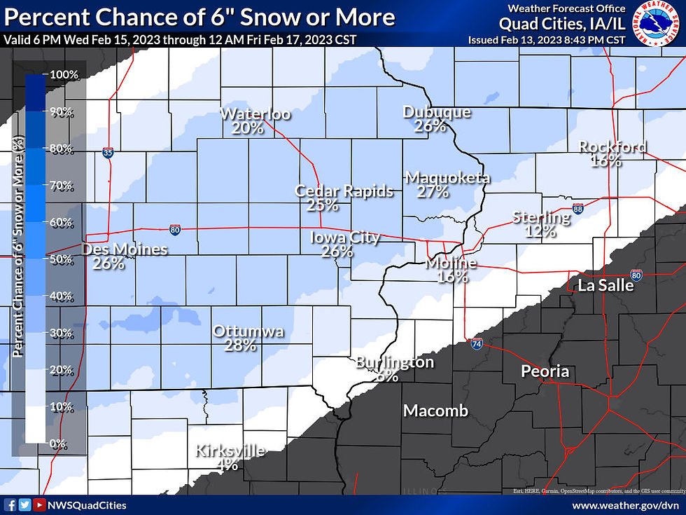
The NWS model currently indicates these odds of a snow threshold of 1, 4, and 6 inches.
1 or more inches

4 or more inches

6 or more inches
The official NWS forecast

As for other models, here is what they are suggesting. Remember, these are not forecasts, just raw model output that help us create forecasts. At least minor changes are likely.
The EURO

The GFS

The 12k NAM

Following the passage of the storm, gusty winds may produce a bit of blowing snow in the open country Thursday afternoon and night. They will also usher in sharply colder temperatures and the big coat comes back out. Here's the lows Friday morning in the single digits north.

Wind chills of 5 below north to 3 above south are shown Friday morning.

Friday';s highs will likely stay in the mid teens to the mid 20s, coldest in the deeper snow cover.

Temperatures will moderate nicely this weekend and should be back in the 30s and 40s. The warm-up will short and sweet as colder air and perhpas another chance of snow is back with us by next Tuesday. Lots of weather on the table. Until next time, have a great day and if you can, please support TSwails with a DONATION HERE Roll weather TS...


Comments