


GOING FULL CIRCLE THE NEXT WEEK...
- terryswails1
- Nov 20, 2020
- 3 min read

What you are looking at in this satellite image is a spectacular November day. There's little weather anywhere and much of the nation is mild, especially the central third of the United States.

Here's the 500mb pattern showing high pressure ridging from west to east across the country. That strong zonal or westerly flow is a trademark of strong La Nina winters. It really limits moisture, especially over the southern half of the country.

It also allows for downsloping east of the Rockies and some nice compressional heating. Look what it did to temperatures Thursday. Highs reached 70 or above from Ft Dodge to the Quad Cities and down to Peoria. Highs near Columbia. Missouri were up to 76!

While readings are going to cool to more seasonal levels the overall temperature pattern does not show much sign of changing the rest of the month allowing above normal temperatures to dominate. The Climate Prediction Center shows this for temperatures November 27-December 3 THE WHOLE country well above average.

It's a dry pattern as well showing the ability of the westerly flow to restrict moisture.
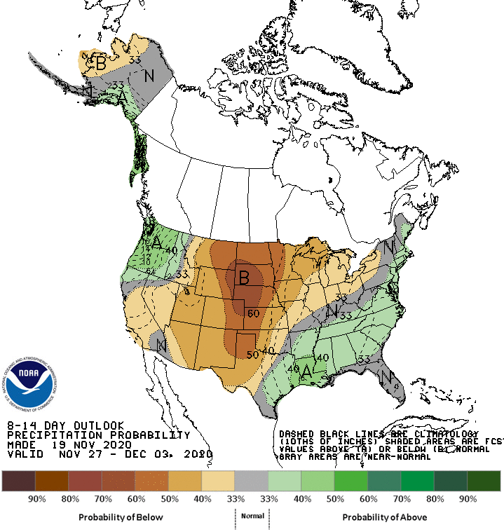
The 8-14 days hazard outlook is as uneventful as you will ever see it from coast to coast. Usually there is some issue somewhere. Not as far as CPC is concerned. That's painful for me to look at.

That system which looked to be a healthy precipitation producer for the weekend a few days ago continues to drift further south. It now appears only extreme southern Iowa and WC Illinois will see any showers late Saturday night or early Sunday and even there they look very much on the light side. The EURO shows this for totals through Sunday.

The GFS is compliant in that solution.

The last issue on the table is the pre-Thanksgiving storm I alluded to yesterday. The EURO has precipitation starting as snow Monday night in the northern half of my area and changing to rain as warmer gets drawn in aloft. The GFS is warmer and keeps the snow well north of my area. Here's the two snowfall forecasts. Again this is Monday night/Tuesday morning.
The EURO

The GFS

It's still very early so don't get caught up in numbers or placement yet but it certainly seems at this point that there could be travel problems early next week, especially to the north in Minnesota and Wisconsin, perhaps far northern Iowa.
Where there is no snow or mix, rain looks likely. This is what the EURO and GFS shows for precipitation totals Monday night and Tuesday.
The EURO

The GFS

The good news is that once this system departs, Wednesday the big travel day before Thanksgiving looks fine. From there on out the rest of the holiday weekend appears quiet and that leads into the nice stretch of weather that I showed you in the 8-14 day period. We'll go full circle the next week. Roll weather...TS

There's no time like the present to order your copy of Derecho 911, Iowa's Inland Hurricane. You can get the inside scoop on this "superstorm" (now the costliest storm in U.S. history) in my soon to be released new book. Save by ordering early and taking advantage of our LIMITED TIME OFFER for the low price of $25.95. It's a coffee table style book that's color and includes more than 100 pictures, graphics, and diagrams. It's intensely researched and will be the authoritative account of this remarkable Iowa storm. It will make a perfect Christmas gift for that hard to buy for person. For more information or to get your autographed copy click the link below. Thanks!


Comments