


GOOD TO THE LAST DROP...
- Oct 28, 2025
- 4 min read
Since the middle of last week, it's been apparent that our next storm system was going to be a challenge to forecast. Energy surging in off the Pacific is drawing a bead on the Midwest, that is, until it encounters a wall of high pressure situated over the eastern Great Lakes. Locked firmly in place, this formidable block will force the energy to take the path of least resistance. In this case, it makes a hard right and curls underneath the block, before eventually turning northeast once beyond its influence. You can see the process unfold at 500mb the next 72 hours.

All the models are in agreement on this circuitous track. Where the challenge exists is determining the strength of the dry air and how it influences rain chances. As of Monday morning, the water vapor loop shows dry air well entrenched locally. However, Tuesday, moisture makes a quick intrusion before getting abruptly cut-off Tuesday night as the storm digs southeast. We get in it, but the window for rain will be relatively short. Notice how sharp the demarcation line is on the east flank of the moisture shield before it collapses again.

On The satellite Monday evening you can see how moisture to the SW is butting up against the dry air creating a clash zone. Currently, my eastern counties are on the edge of that convergence where a struggle will be ongoing for saturation, a key component to the precipitation process.
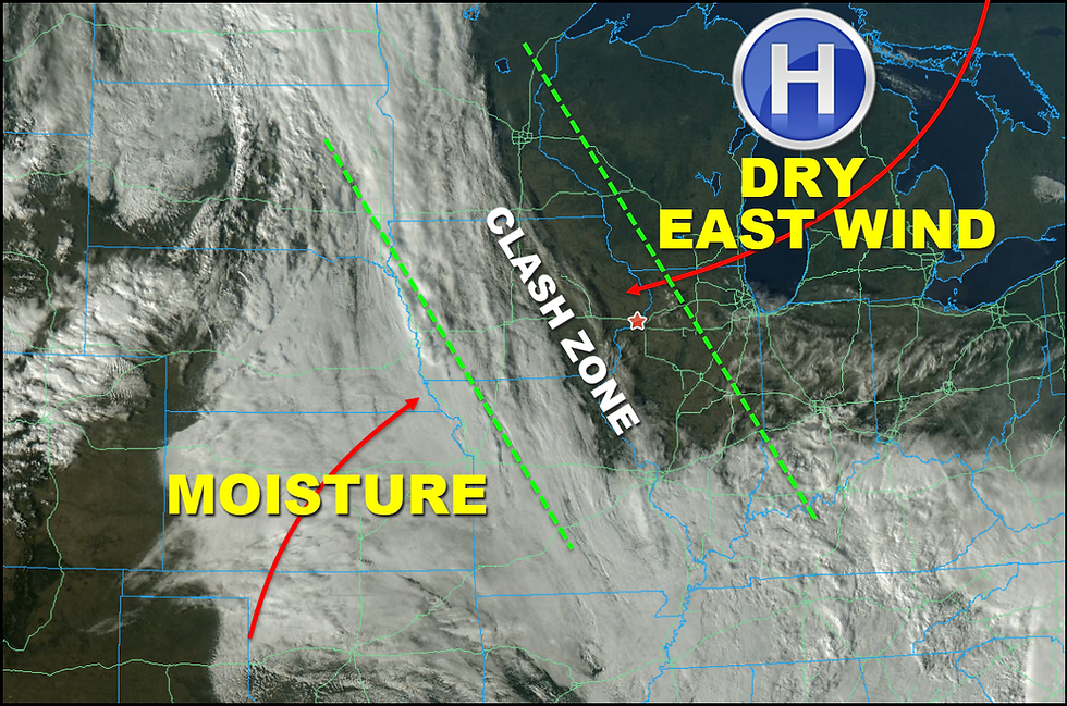
The animation shows what a difficult time moisture is having progressing into eastern Iowa Monday.

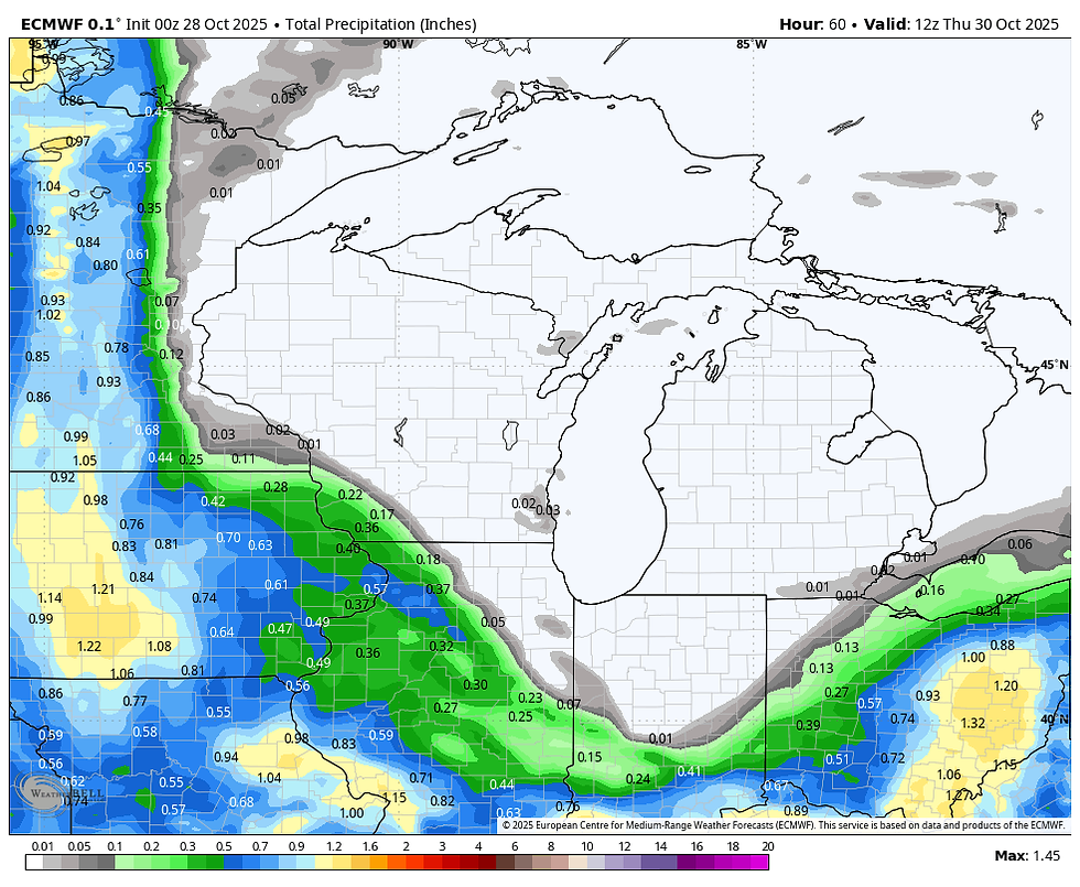
Anyway, the burning question is, to rain or not to rain Tuesday afternoon and evening? One thing that does seem apparent is that the western half of my area, (especially my counties in Iowa) have the better chances for meaningful rain where the dry air will have less of an impact. From a model perspective, we essentially have two camps. The EURO is the furthest east with the rain shield, producing 1/4 to 1/2 inch rain totals in much of my area. Take a look.
The EURO
The HRRR shows a similar trend.

The GFS and 3k NAM are banking on the drier being more dominate and are further west with the dry air, and show little if any rain northeast of the Quad Cities. Southwest of there, totals are down to the 1/10th to 3/10ths of an inch range.
The GFS

The 3K NAM

The NBM (National Model Blend) falls into the lesser camp of the GFS and 3k as well.

It's really tough to know how this ends up, but I feel the dynamics are strong enough to inch the moisture a bit further east than what the GFS shows. I am hedging my bet towards the higher amounts of the EURO. However, that's far from certain, and hopefully early Tuesday models will all come in with a more uniform look.
Winds around the system will start southeast, swing to the east, and finally northeast as it makes its way towards Tennessee Wednesday. The general easterly component, along with additional clouds, and a period of rain or showers will keep highs on the cool side. In fact, with the pattern blocked by the slow movement of the storm, the East Coast trough, and Milton out in the Atlantic, high temperatures Tuesday through Sunday should remain in the range of 53 to 58 degrees. Some passing clouds can be expected from time to time as a few weak impulses of energy drop into the mean trough. A couple of these look just strong enough to kick up a few showers later Friday and again Saturday as they pass. These are likely to be widely scattered, and any amounts would be quite light.
VISIT US AT MY 5-STAR GALENA AIRBNB.

My 5-STAR AIRBNB just outside of Galena is a premier Midwest destination and a guest favorite! We take pride in our perfect rating, amenities and cleanliness. Take advantage of our fall and winter specials and instantly save $200. Book directly with us and eliminate AIRBNB fees and additional costs that will save you cash. Other discounts apply. Call or text Carolyn at 563-676-3320 for our best deal of summer. See more at https://www.littlewhitechurchgalena.com/
MORE OF THE SAME LONG RANGE
Longer range, the ensembles of the EURO show a fairly progressive pattern, in other words, regular progressions of high and low pressure systems the next two weeks. With the wave lengths short, temperatures are not likely to be too extreme one way or the other. That's the reason for its 2-week temperature outlook showing such a small range. That said, I would not be surprised to see some readings in the low 60s in early November.

Additionally, precipitation is not shown to be extreme as well. The 2-week departures depict totals near normal.

Between now and November 11th, the EURO shows minimal snowfall throughout the eastern half of the nation.

One thing that did pique my interest was the EPO (Eastern Pacific Oscillation) on the EURO extended. In early December it literally tanks, over 7 standard deviations below the baseline of 0. That would imply a powerful ridge off the Pacific Northwest that would open the door wide for cold air to enter the country east of the Rockies. That's a pretty extreme solution and something to keep an eye on (along with the MJO) as November evolves.

Meantime, here's hoping we can get a little of that much need rain. Anything we can get will be good to the last drop. Roll weather...TS


Comments