GREEN, GREEN THE GRASSES GROW
- Apr 22, 2025
- 3 min read
It seems to take forever, but the combination of recent rains and warmer days has nature in a growing frenzy. The grass is a vivid color of green that has a limited shelf life. Add to that the flowering crab trees and brilliant tulips, and you have the pallet of spring. Now all we need is some warmer temperatures and a blue sky and the picture is complete. All of this is in the cards the next few days, and I will get to that in a minute.
First, the Easter Sunday storm made news with some rains that were a long time coming. My western counties, closer to the track of the system, were treated to amounts in the 2-3 inch range. Cedar Rapids officially picked up 2.34" Sunday, which broke the 24-hour rainfall record for April 20th. Also, it was the wettest calendar day in Cedar Rapids since June 25th, 2022 (2.99").

Additionally, it was the wettest Easter at the Cedar Rapids, Airport since records began there back around 1950.

Many areas from Wisconsin to Missouri got in on the soakers. Here's a closer perspective of where the heavier rains banded over my western counties in Iowa.

Keven Walters, a long time weather buddy and chaser, sent me this picture of his rain gauge in Conrad. Iowa, north of Marshalltown. A little over 3 inches out that way. He was so happy to see it that instead of emptying the gauge, he chugged it....bottoms up Kev!

The system was very dynamic and entered SE Iowa with enhanced shear Sunday evening. A couple of quick tornado spin ups were noted south and southeast of the Quad Cities. Fortunately, heating was limited and that greatly reduced instability and what could have been a significant tornado threat. We'll take that. Even so, a tornado watch was issued for much of my area from about I-80 south. You can see the storms lined up along the advancing cold front Sunday evening.

That left us with a blustery cool Monday with cold air advection in full force. High remained in the upper 50s to low 60s.
The next 7 days, the mean upper air pattern at 500mb is expected to look like this. W/SW flow seems destined to rule and that should keep readings mild, mainly in the low 60s to mid 70s.

The ensemble means of the EURO do indicate well above normal temperatures for most of the nation east of the Rockies through April 29th.

The Weather Prediction Center has locked in on that in its 6-10 day outlook.

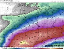
With that SW orientation to the jet, energy producing precipitation is likely to come out of the flow from time to time. Below, you can see the projected rainfall departures over the next 7 days are expected to be above normal, more so in my counties in Iowa.

That also syncs up well with what WPC is projecting in its 6-10 day precipitation outlook.

The first opportunity for showers and perhaps some storms is already in play Tuesday morning as return flow kicks in. Coverage is expected to be greatest in my central counties, with lighter amounts (if anything) north and south of there. This first bout of wet weather should wane and die out Tuesday morning, allowing enough heating to eventually get highs into the range of 70-75. Later in the afternoon and evening, a bit of an outflow boundary from the earlier rains could ignite some additional storms, especially near and south of I-80. Those should move out of that area in the late evening.
A stationary boundary will waver around my central counties the remainder of Tuesday night. With the addition of the low level jet after dark, some additional shower and storms are possible beyond midnight. What's left of those departs Wednesday morning. The daytime hours of Wednesday should largely be dry before another batch of showers and storms develops Wednesday night near the boundary, which may be more in my northern counties. Temperatures Wednesday could be influenced by clouds, but I'm thinking enough sunshine for highs again in the low to mid 70s.
Rain totals are not going to be excessive, but where the stronger storms occur, or where more than one round is found the next 48 hours, some 1 inch+ amounts are possible in spots. Here's what guidance is suggesting.
The EURO

The GFS

The 3k NAM

The 12K NAM

Overall, the severe threat appears to be small through Wednesday night, although a couple strong storms might kick out some hail. Spotty heavy rains are the primary concern.
Additional showers and storms are possible later in the week, especially Thursday night and Friday. There are still some details to work out regarding timing and strength. That's all for now. Until next time, roll weather...TS.


Comments