


HEADED FOR THE DEEP FRYER
- Jul 26, 2025
- 4 min read
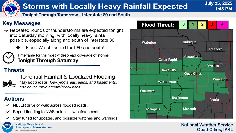
There's an old saying, if ain't one thing, it's another. That's the situation the central Midwest is facing this weekend as growing heat initiates heavy thunderstorms, that will be followed by some brutally hot conditions both Monday and Tuesday. Some areas are already under a flood watch, and many others may eventually go under an excessive heat watch. All things considered, several days of impactful weather are on the table.
The initial concern as the heat builds is with thunderstorms that develop in a tropical atmosphere well-endowed with moisture. Below is an animation showing available water vapor Friday evening through Saturday. The red shades indicate PWATS (available precipitable water vapor) of 2 or more inches in a swath covering the majority of my area.

For perspective on how incredibly moist the atmosphere will be during that 24-hour period, consider that levels of that magnitude are in the 98-99th percentile of climatology. Additionally, steering currents are weak, indicating slow storm movement of just 10-20 mph. On top of that, freezing levels are high up to 15,000 feet. Warm cloud depths such as that are known to be excessive rain producers, with hourly rainfall rates greater than 2 inches an hour. Any place that can see even a meager updraft will have the potential for torrential downpours and heavy rain. Fortunately, both forcing and shear are on the low end, which hopefully offsets the other parameters favoring high-end rainfall totals. I expect that there will be at least localized swaths of heavy rain focused on my area near and south of I-80.
The Weather Prediction Center indicates at least a slight risk of excessive rains over all but my far northern counties through Saturday morning.

With all the parameters in play, the NWS has issued a flood watch through Saturday for the threat of torrential rainfall and localized flooding. Storms in Muscatine and Louisa counties in Iowa Friday afternoon prompted flash flood warnings due to 2-3 inch rains in a brief period of time.
Due to clouds and periods of showers and storms, Saturday's temperatures won't get out of line, remaining at seasonal levels in the low to mid 80s. That said, dew points in the mid to upper 70s will make for a very steamy, uncomfortable day.
IT'S TIME TO VISIT TO MY 5 STAR GALENA AIRBNB

My 5-STAR AIRBNB just outside of Galena still has some openings this summer. All of our ratings are 5 star! We take pride in the amenities and the cleanliness. If you book now, we'll take off $200, and we can eliminate AIRBNB fees and additional costs that will save you big bucks. Other discounts apply. Call or text Carolyn at 563-676-3320 for our best deal of summer. See more at https://www.littlewhitechurchgalena.com/
FEELING SQUEAMISH...
If that makes you squeamish, what comes next should put you way over the edge in coming days. Intense heat that's been centered to the south since Wednesday is set to flex its muscles once again. It begins to infiltrate the area Sunday, inching north as the heat dome expands. By Monday, 500mb heights are shown on the GFS reaching 597 (dam) which again is approaching 98-99% of climatology.

That allows 850mb temperatures to hit +25C, meaning the air a mile up is exceptionally hot. That creates a capping inversion that makes it hard for thunderstorms to thrive despite extreme instability.

The cap begins to take hold Sunday, implying that any storms that day should remain widely scattered at best. Surface temperatures also grow warmer, with highs in the upper 80s north to the low 90s south. Heat index values of 99-105 will most likely require heat advisories, especially for the area along and south of I-80.
Monday has the makings of a very oppressive day. With the big cap thwarting storms, ample sunshine is expected, allowing highs to reach the range of 91-95.

Unbelievable dew points of 81-84 continue to be indicated, showing vast amounts of low level moisture.

The combination of hot temperatures and off the chart moisture has the potential to generate extremely dangerous heat index values. The GFS points to SC and SE Iowa as the spot where the worst values are expected. That corridor is shown sporting heat index values of 116 to 123 degrees! You heard me, 116 to 123. That's 3 days away, and hopefully those numbers come down at least 5–6 degrees between now and then. Even if they do, on the low-end, most spots have a good shot at seeing a heat index of 108 to 116 degrees Monday if the GFS verifies. That would easily constitute extreme heat warnings. A watch is probable before that.

The experimental HeatRisk product generated by the NWS shows a large chunk of the eastern U.S. with a level 3 of 4 major risk from heat. Major - Affects anyone without cooling/hydration as well as health systems and industries.

Tuesday looks rough again but not as vicious, with the core of the heat showing signs of shifting slightly southeast, especially on the EURO. The GFS however, shows another blistering day across the board with heat index values of 106 to 112, highest again near and south of I-80.

All guidance suggests the heat will break Tuesday night with the passage of a cold front. This is also a period to watch for active thunderstorms as the transition takes place. Timing of the front will be critical to the strength of any storms, and it's far too early to get a grasp on that mesoscale detail yet. It's always nice to end with good news, and in this case it's the temperatures the GFS is promoting late next week into the ensuing weekend. Feast your eyes on the 4 days of 70s it shows July 31st-August 3rd. Beyond that, 3 more days in the 70s are shown the 6th through the 8th. Here's hoping!

That's the nuts and bolts of it, heading into the weekend and an unwelcome trip into the deep fryer. Play it cool and roll weather...TS


Comments