


HOW SWEET IT IS...
- Sep 30, 2025
- 3 min read
This is the time of year when we are usually concerned with the tendency of our weather to turn colder and often times frosty. That day will come, but it sure won't be anytime soon. Before we delve into the future, I just wanted to give you some perspective on how warm temperatures have been this month in the Quad Cities. Through Monday, we have gone 20 consecutive days with above normal highs. 22 of the month's 29 days have been in the 80s, with 5 days in the 90s. The average high Today is 71, but should end up closer to 91.

On the flip side, the humidity has been so low that nighttime temperatures have generally been comfortable in the range of 50-60 the last two weeks. That has allowed many of us to use the air conditioner only sparingly. These large diurnal spreads in temperatures were especially evident last Thursday when readings went from a low of 48 to a high of 88 (a rise of 40 degrees).
It's interesting to see in the graphic below how over the past 3 days the dew point has remained fairly consistent in the range of 50-60 (10 degrees). On the other hand, temperatures have fluctuated widely in the range of 57 to 91 (34 degrees) due to the dryness of the air.

Something else that is very consequential is the fact that for the past 2 weeks, outside of NW Alaska, most of North America has seen above average temperature departures. There's just no cold air to speak of.

Over the next 10 days, only minor changes are expected with well above average temperatures expected, especially across the center of the nation.

In fact, over the next 7 days, temperatures are expected to average 13 to 15 degrees above normal per day. Coming on top of the past 20 days, that will make for an extremely warm stretch of warmth that's unprecedented.

The EURO (and for that matter the GFS), shows a break in the mild temperatures around October 6th or 7th. It looks rather dramatic compared to what we are currently seeing, but by then, the upper 60s will actually be close to where we should be at that point in the month.

While many areas could challenge record highs on Tuesday, most spots will probably end up 1–3 degrees below the existing records. Here's what's needed to get a record done.
Record highs for September 30th...
Burlington, IA.........91 in 2023 and previous years
Cedar Rapids, IA.......94 in 2023
Dubuque, IA............89 in 1897
Moline, IL.............92 in 1952
The last thing I will mention regarding the warmth is that too much of a good thing can be problematic. Steve Gottschalk, my climate GURU in Lowden, Iowa for more than 60 years, has now measured 9 days this month with highs in the 90s (tying records both Sunday and Monday with highs of 90 and 91). Only 2 other years had 9 days of 90s, 1971 and 1978. Both produced cold and snowy winters. 1971 had 55.2 inches of snow and 1978 was epic with 90.6 inches. Now there's some food for thought. Thank you, Steve.
PLAN A VISIT TO MY 5 STAR GALENA AIRBNB

My 5-STAR AIRBNB just outside of Galena still has some fall openings. All of our ratings are 5 star! We take pride in the amenities and the cleanliness. If you book now, we'll take off $200, and we can eliminate AIRBNB fees and additional costs that will save you big bucks. Other discounts apply. Call or text Carolyn at 563-676-3320 for our best deal of summer. See more at https://www.littlewhitechurchgalena.com/
WHERE FOR ART THOU RAIN?...
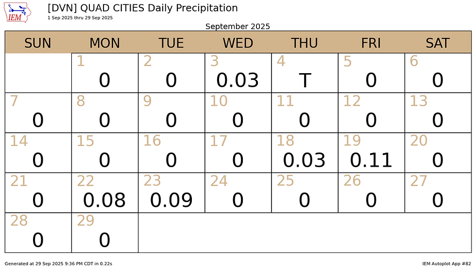
The last item on the mind of many is when are we ever going to get any rain? The NWS office in Davenport has had just .34 inches the entire month of September and will conclude it dry Tuesday. Just 5 of the 30 days will end up seeing measurable rain (16% of the possible days).
At the airport in Moline, yearly rainfall was running close to normal July into early August before flat lining. Today, totals are roughly 3 inches below normal.

We really could use a soaker, but both the EURO and GFS show nothing through Sunday of the upcoming weekend.
The EURO

The GFS

There are some signs that a slow moving front could bring a better chance of more meaningful rains Monday into Tuesday of next week. I would not get your hopes up just yet, but it's the next chance of anything worthwhile. Fingers crossed.
Meantime, it's more of the same Tuesday, with dry air and near record highs. What a sweet way to end the month of September. Roll weather...TS


Comments