INDIAN SUMMER, NOT EXACTLY
- Oct 8, 2025
- 4 min read
It took some doing, but we finally broke the back of our fall (late summer) weather pattern. High pressure is now back in full control and will dominate our weather through the coming weekend. Pleasant days and cool nights are on tap until our next warm-up commences this weekend. In fact, the stretch of weather that's coming would qualify as Indian summer (a classic fall weather term) except for one thing, we haven't had a frost, a technical requirement.

Here’s what generally constitutes Indian Summer weather:
Timing
It happens after the first killing frost or freeze of autumn.
Usually occurs in October or November in the Northern U.S., but can extend into early December.
Temperature
A period of above-normal warmth, often with daytime highs in the 70s or 80s° in the Midwest
Temperatures feel “summerlike” compared to the season’s normal chill.
Weather Conditions
Dry, sunny skies with very little precipitation.
Often accompanied by light winds and hazy conditions (from dust, leaf smoke, or stagnant air).
Duration
Lasts at least several days in a row, not just one warm day.
Regional Understanding
In popular culture, many people call any warm spell in the fall “Indian Summer,” even if there hasn’t been a frost first.
But in the stricter, traditional definition: a warm, dry spell after the first frost is the true Indian Summer.
👉 So, if you’re in Iowa or the Upper Midwest, you wouldn’t technically call a warm stretch in late September or October “Indian Summer” unless a frost had already occurred.
In the Quad Cities, a true Indian Summer is not guaranteed every year, but when it does occur it’s usually choice — a week of golden leaves, blue skies, and 70 degree warmth following that first frost that's already reminded you that winter is knocking on the door.
Here’s a table of Quad Cities Indian Summer events (1995–2024) showing highs that reached 70 after the first frost. You can see which years had a true Indian Summer compared to those that didn’t. More often than not, we get one.

PLAN A VISIT TO MY 5 STAR GALENA AIRBNB
My 5-STAR AIRBNB just outside of Galena still has some fall openings. All of our ratings are 5 star! We take pride in the amenities and the cleanliness. If you book now, we'll take off $200, and we can eliminate AIRBNB fees and additional costs that will save you big bucks. Other discounts apply. Call or text Carolyn at 563-676-3320 for our best deal of summer. See more at https://www.littlewhitechurchgalena.com/
BACK TO HIGH AND DRY....
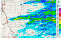
Since it looks like rain is out of the picture for some time to come, hopefully you were one of the fortunate ones who got in on the heavier amounts. Basically, that was confined to a region that was a 20–40 miles wide that ran from Lamoni in SC Iowa to about the Quad Cities and then on to Chicago. Prophetstown racked up 1.66" and much of the Quad City metro saw amounts around an inch. Other spots like North Liberty and Bettendorf only managed .05". Feast or famine.

The late day GOES 16 satellite image Tuesday depicts the front to the east, with its clouds and rain along with it. Behind it, high pressure is holding sway. While the weather will be stunning, the next 2 nights dry air, clear skies, and light winds will allow some of the coolest readings of the fall so far. Lows of 40 to 45 will be common. Thursday morning looks to be the coldest, with a spot or two possible reaching 38 to 39 in the valleys of the north.

Lovely fall weather is expected during the day, with considerable sunshine and near to slightly above normal temperatures Wednesday through Friday. Highs should hold in the range of 65 north to 71 south during that period.
After that, a significant warm-up is anticipated as another high pressure ridge builds with a return flow of southerly winds. The EURO is especially bullish, sending highs into the upper 70s to mid 80s Tuesday through Saturday of next week! It is also less phased at 500mb, with the next trough around the 18th. The split flow does not allow the cold air that was shown yesterday to reach the central Midwest.

The GFS tells a different story as it drives a strong cold front through the 17th, which abruptly ends the warmth and drops temperatures into the 50s the 19th-23rd. That's consistent with what it showed yesterday. Needless to say, confidence has lowered today with regard to week 2 temperatures. Teleconnections do favor the cooler solution of the GFS more than the EURO for what it is worth.

Aside from a chance of showers Thursday night, forcing and moisture look negligible the next 10 days, ensuring more in the way of below normal precipitation. This is what the EURO and GFS suggest for rain totals through October 17th.
The EURO

The GFS

All things considered, it looks like we've got our one day of bad weather behind us and can resume Indian Summer conditions again (we'll just ignore the fact it's fake)! Roll Weather...TS


Comments