IT'S BUMP DAY AND THEN WHO KNOWS...
- terryswails1
- Oct 13, 2020
- 2 min read
Hump day will be "bump day" as far as temperatures go around the central Midwest. Readings will start cool but soar in the afternoon as strong SW winds advect warm out ahead of a low pressure passing through Minnesota. The set-up looks good for highs in the central and southern parts of my area to reach 75 to 80. The north will be impacted by a late day cold front that will keep readings several degrees cooler. Here's what the GFS has for highs

As mentioned, wind will be a factor with some gusts reaching into the range of 35-40 mph. Below are 10 meter gusts just above the surface so they will be 5-10 mph stronger than what we are likely to see at ground level. Still Strong.

Then we begin a cooling trend that ushers in much colder temperatures for the end of the week. Highs Thursday and Friday will be down a good 20-25 degrees holding in the range of 50-55 in most spots. The GFS has this for a 24 hour temperature change Thursday. A stiff breeze will make it feel even colder.

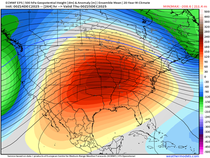
Beyond Friday the GFS and EURO diverge widely and that means confidence is low with what happens late weekend and next week with regards to temperatures and precipitation. The 500mb pattern of the GFS and EURO side by side show the major difference in the depth of the trough. The GFS is on the left the EURO right.

This is huge a huge forecast problem as the GFS solution is very cold and even snowy. The EURO is showery but much warmer, especially at the critical thickness levels necessary for snow. Look at the extreme difference! The GFS has a 5,000 foot temperature of -10 while the EURO is at +14 C.

I can't begin to tell you the difference that makes in the sensible weather pattern in my area. Let's start with snow. The GFS dumps 3-5" of wet snow over my entire area.

The EURO being far too warm doesn't even show a flake.

The temperature contrast is just as eye popping. The GFS Monday morning has readings in the low 20s.

The EURO is in the low 60s. UGH!

Very clearly one of these models is initializing data poorly and it's throwing the whole run down the toilet. I always lean towards the EURO in a situation like this 5 days out. It's also so early in the season that it's rare to get the type of cold air mass the GFS is showing so far south with precipitation within it. There's also a very strong eastern ridge that I think is providing the resistance that's holding the cold back on the EURO. So, despite recent consistency in the cold snowy GFS solution, I would be very surprised if it wins this battle. I expect the GFS to blink in the next day or so.
Whatever happens, this is going to have a big impact on the extended forecast which is very low confidence as of Tuesday night. I'm anxious to see how it plays out. There will be flakes in some part of the Midwest but the ones that add up are likely to be north of my area. Roll weather...TS


Comments