


LIVING ON BORROWED TIME
- Feb 18
- 4 min read
A SINCERE AND HOPEFUL MESSAGE

Friends and lovers of weather, it's imperative that you know I must reach my financial goal or it's time for me to hang it up after 50 years. I'm doing the best I can here to win your support, and rest assured there is no pleasure in asking for money. I get that its hard times and that's why I'm doing all I can to keep TSwails a no pay site. No matter what, I'm here through December, but the 14th year beyond is dependant on you. If you can help my cause, I'm making a humble plea for anything you can swing, it all adds up. Im $3,000 dollars (or 83% from my goal). Last but not least, I earnestly thank the 302 amazing individuals who have made such gracious contributions. You are all true treasures! Roll weather...TS
KEEPING IT MILD...
Temperatures were 6-10 degrees cooler Tuesday, but in the world of averages, it was still a keeper with highs 20 degrees above normal. More like a mid-April day. I took this picture at sunset from my deck overlooking Dubuque and the Mississippi RIver. The sky was on fire, a mantle of burning coals. Just a cool was the river and its ice reflecting the sky above. Pretty mystical stuff!

Let's get things rolling with Tuesday night's low level water vapor loop. There is energy galore, but I want you to focus on the yellow colored band cutting across Arizona and Texas northward into Iowa. That is a pronounced plume of dry air known as a dry slot. Storms are out there, but we can't seem to get situated in a spot that provides the moisture and forcing necessary to deliver rain or snow.
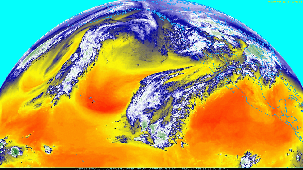
To my point, available water vapor Wednesday morning is shown as low as .10" over parts of Iowa. I spotted a shower near me Tuesday evening but aside from a sprinkle, most of the rain evaporated before reaching the ground. The rain shaft was visible leaving the cloud but disappeared halfway down as it hit the bone dry lower levels of the atmopshere.

Anyway, Wednesday will be another dry day with humidity levels at midday expected to be in the teens while values west of Minneapolis are 90-95%. Close but no cigar.

With the dry in place and a bubble of high pressure, temperatures will again reach into the upper 50s north to the mid 60s south, 20-24 degrees above normal.

Wednesday night the focus shifts to a developing low pressure that tracks into EC Iowa late in the day Thursday. At midnight the center of circulation is near Freeport, Illinois.

Such a track sets up another day of 60 degree highs (or warmer) SE of the Quad Cities. Further NW, readings remain closer to 50.

The system does tap into some moisture with water vapor noticeably higher than Wednesday. As a result showers develop late in the day or evening. A thunderstorm is even possible SE of the Quad Cities where some small CAPE is indicated ahead of the surface low and its cold front.

While rainfall in most areas appears light, a few spots just NW of the Quad Cities could see amounts of 1/2 to 1/2 inch in a narrow band to the left of the surface low track. Here's some rainfall forecasts.
The EURO

The GFS, further NW, lighter, and most likely on the light side.

The 3k NAM

Later Thursday night or early Friday, some snow showers may wrap around the low just catching my NW counties. A dusting is shown on the EURO near HWY 20 north. Far NE Iowa is shown with substantially more.

Cold air advection is shown surging into the area Friday morning. and after highs in the low to mid 30s, steady or falling temperatures appear likely. Strong NW winds up to 35 mph will make for a raw day, expecially in the NW where some snow showers are expected in the morning.
The weekend will be dry but nothing to write home about with temperatures dropping below normal. HIghs of 30-35 Saturday drop to 24-29 Sunday. Wind chills come Sunday will be in the range of 5 NW to 15 SE. That's a wake up call!

Next week appears to be another parched one with below normal rain totals shown over the 10 day period ending February 27th. I don't like seeing those big departures in the Gulf states when we're so behind on precipitation. That's a really dry signal.

After Monday, readings start to modify once again with the GFS popping a few more 60s towards the end of the month.

The EURO is not as bold and I would not get overly excited about the GFS just yet. However, with that negative PNA it could certainly be warmer than what the EURO shows.

Another pretty good day awaits you. Embrace it and roll weather....TS ON A SERIOUS NOTE, IF I CAN'T MEET MY FINANCIAL GOALS, THIS WILL BE THE LAST YEAR OF THE SITE. IF YOU LIKE THE CONTENT, THE FUTURE IS UP TO YOU. T.S. 83% to my goal.


Comments