


NOT DONE WITH SNOW JUST YET...
- Mar 8, 2022
- 4 min read
Before I get to the issue of snow and more wintry weather, just a note on the tornado outbreak in Iowa over the weekend. Once again, this was a historic event for the state...the third in less than a year and a half. The first was the 2020 derecho which is still the costliest thunderstorm in U.S. history. The other was the last December's serial derecho which produced over 60 tornadoes, the most for a single day in Iowa history.
Saturday's event First violent tornado of the year, first EF4 in Iowa since October 4th 2013 and second longest tracked tornado in Iowa since 1980. This is the first EF4 tornado in Iowa since October 4, 2013 in Woodbury and Cherokee Counties - This is the second longest tornado path in Iowa since 1980. The longest occurred on June 7, 1984, with a pathlength of 117 miles in southern Iowa. By latitude of touchdown, the Winterset-Newton EF-4 was the farthest north violent tornado so early in the year in the US since 1950. (The old record was the Worthington, IA and York-Schuyler, NE tornadoes on March 13, 1990

The peak winds reached 170mph, the maximum width was 800 yards, and the tornado was on the ground for 1.5 hours. The track took it just to the southeast of the Des Moines metro area.

Monday's EF4 designation makes the twister the furthest north violent tornado this early in the year since at least 1880, per Tornado Archive.

Here's a look at the multiple vortex twister near peak intensity Saturday evening in central Iowa. Weird to see a wedge like that with no green grass or leaves on the tree.

On of my buddies, Kholby Martin asked me to go chasing with him Saturday but I had a previous commitment and had to pass. Here's what I missed out on. Tennis ball sized hail that knocked out his windshield. You can see it covering the ground behind him. That would have been interesting! By the way, it takes a certain mindset to be happily smiling after your cars been dented and the glass broken out.

Here's the severe weather reports from Saturday's early season outbreak. 47 tornado reports and 260 combined reports including hail and high winds. No doubt this is the most significant early season severe weather outbreak in Iowa history.

Just imagine recovering from the damage of tornadoes and severe weather and 24 hours later digging out of several inches of snow. That's another unusual aspect of this storm. Coming so early in the season plenty of cold air followed the system allowing snow to develop Sunday night. Rarely have I seen that extreme phenomenon. No matter how you slice it, this was another big ticket weather event for the central Midwest, especially for the state of Iowa.
On the topic of snow, the Sunday night event was a quick hitter with most areas picking up 2-6 inches of wet white gold. Some of the lower end totals occurred in the region around the Quad Cities (the black hole strikes again), where amounts were 2 inches or less. The heaviest band ran along a line from about Iowa City to Guttenburg where 5-7" totals were common.

Some specific snowfall reports from NWS offices around the region.

Tuesday thanks to fresh snow cover and high pressure, the day gets off to a calm but cold start with readings in the range of 10-15 degrees. However, southwest winds ahead of an approaching cold front allow temperatures to break the freezing mark by afternoon and melt more snow. Highs are expected to reach the mid 30s north to the low 40s south. Wednesday looks quiet as well with readings mainly in the low to mid 30s. Skies both Tuesday and Wednesday are expected to be mostly sunny.
MORE SNOW LATER THURSDAY?
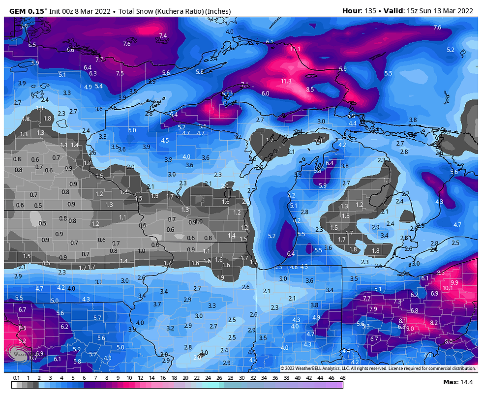
Clouds move back into the region Thursday along with chances for more snow. Monday's data has shown a deeper push of Tuesday's cold front and that's important as its driven the snow system further and further south in recent runs. It's pretty clear that models are having issues resolving the energy and it may be another 24-36 hours before the system shows its hand. That said, the southward trend has merit and it appears the area near and south of I-80 has the best chances of seeing the heavier snows of 1-3 inches. Here's what models are currently suggesting for potential accumulations. Confidence is low on any of these solutions panning out. I'll start with this story board produced by the NWS which looks too aggressive and too far north.

The GFS

The EURO

The GEM
No matter how much snow falls, cold air pours in behind the system and the coming weekend gets off to a very fresh start. The EURO shows this for temperature departures Saturday morning. A lot of places are are coming in with readings 20-30 degrees below normal.

However, there is light at the end of the tunnel and during the period March 15th-March 20th, temperature departures over that 5 day period are significantly better. I'm all for that.

In summation, after a wild few days of weather, things look cool, calm, and collected through Wednesday. After that, it's back to some degree of winter Thursday though Saturday. Roll weather...TS
PLEASE CONSIDER SUPPORTING TSWAILS...

Hi everybody, I'm asking that those of you who find value in the site to consider a $12 dollar voluntary subscription covering operating expenses and the time and effort I put into the site. My $12 dollar asking fee is the cost of a pizza or a dozen donuts. Those are gone in a day, TSwails.com is here for you all year long. It's a heck of a value and all I'm asking is that if you enjoy the site and see value in it, that you please consider a voluntary subscription. I'm asking $12.00 dollars a year. That's $1 dollar a month or 3 cents a blog. Thank you for your support and consideration. Terry


Comments