


STORMS BEFORE A SHOT OF MUCH-COOLER AIR
- Aug 18, 2025
- 2 min read

The hot and active weather pattern will persist for (at least) one more day with thunderstorms, some strong to severe, likely across the region on Monday as highs push back into the upper 80s to near 90 degrees. Heavy rain and flash flooding will be a concern once again with high moisture levels still in place for the time of year ready to fuel the next round of storms.
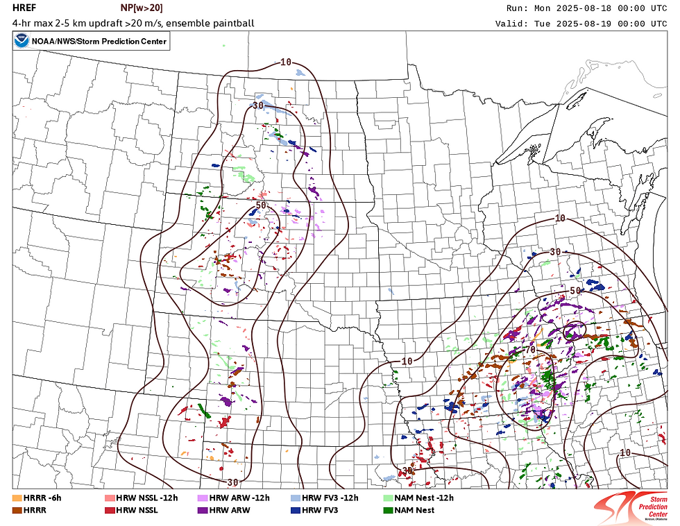
Unlike the last several days the confidence is rather high on the timing and placement of storms Monday afternoon and evening among the suite of models available. Above, the members of the HREF show very good agreement in stronger thunderstorms in the eastern half of Iowa and northwestern Illinois by 7 p.m. Monday. The strongest storms will be capable of producing large hail and strong wind gusts.

In addition to the severe weather threat there will be a concern for flash flooding with atmospheric moisture levels in the 90-99th percentile indicating an environment capable of very heavy rainfall. Rainfall rates could be in the neighborhood of 1-3" per hour. Not quite record-breaking moisture, but certainly problematic.

Before the storms we will once again be dealing with the heat and humidity across the region Monday. Triple digit heat indices are likely, especially south of Highway 30 which includes the Quad Cities region. Remnant outflow from thunderstorms Sunday night will likely help keep temperatures down a bit farther north.

As a cold front sweeps through the area Tuesday temperatures will start a downward trend through the middle part of the week. Tuesday evening the temperature anomalies will be quite lower. A beautiful sight!

Highs quickly fall off a cliff with not only 70s in the forecast, but potentially low-70s early next week. Morning low temperatures could flirt with the upper 40s in low-lying areas if you can believe it. Let's give the AC a break!

That stronger shot of cooler air arrives during the weekend with temperature departures reaching upwards of 10° on the cooler side of normal. That will be quite refreshing for this time of year! Maybe start thinking of how to enjoy the cooler temperatures outdoors... with a bit of a catch.

This shot of colder air this weekend will originate from the Arctic. Through the week the winds will come sweeping across the Canadian Prairie before entering the Midwest United States. While it is mostly good news in terms of the temperatures, air quality concerns will return with wildfire smoke poised to take the Arctic Express into the United States.

Looking at the current status of wildfires in Canada, the air that will be coming late this week will be passing right over the dozens and dozens of out of control fires across Saskatchewan and Manitoba. So the air will be cooler, but the air quality could be a point of concern given the amount of smoke that could be transported into the region. Either way, hazy skies and vibrant sunsets are likely in store.

Analogs are strongly hinting at the cooldown with probabilities of below normal temperatures sitting at 80-90%. It is looking great, friends! Have a great week.
-Meteorologist Nick Stewart


Comments