


PARTY LIKE IT'S AUTUMN
- Aug 22, 2025
- 3 min read

The big story, and really the only weather story for the region, is the cooldown coming this weekend into next week with temperatures running well below normal for this time of year. Sunday night through Tuesday night will see widespread low temperatures 10-15 degrees below normal, correlating to temperatures in the upper 30s far north of mid 40s in the south.
For what it's worth the Pumpkin Spice season officially starts at Starbucks Tuesday Aug. 26 - perfect timing!

By Wednesday morning the surge of cool temperatures pushes well into the southeast US as well bringing the autumn temperatures to all. These morning lows are more reminiscent of late September instead of late August. Not a lot of complaints I am sure.

Tuesday morning temperatures have a chance of breaking records in some locations across the region. The latest forecast has potential low-temperature records in Omaha, Nebraska; Kansas City and Springfield, Illinois. Also note in the UP of Michigan and far northern Minnesota temperatures are forecast to dip into the 30s! Watch for frost advisories in the coming days.

The upper air pattern continues to support the big cool down with strong northwesterly flow bringing the cooler, drier air to the region. This pattern will become somewhat entrenched as well through the first few days of September, therefore below-normal temperatures will remain the theme for some time here in the Upper Midwest.

Around the first weekend of September ensemble guidance, notably from the American GEFS, indicates a trend back to above-normal temperatures heading into mid-September. This is likely, but keep in mind it gets harder to get hot this time of year. We may be done with the absolute worst of summer, at least of now.
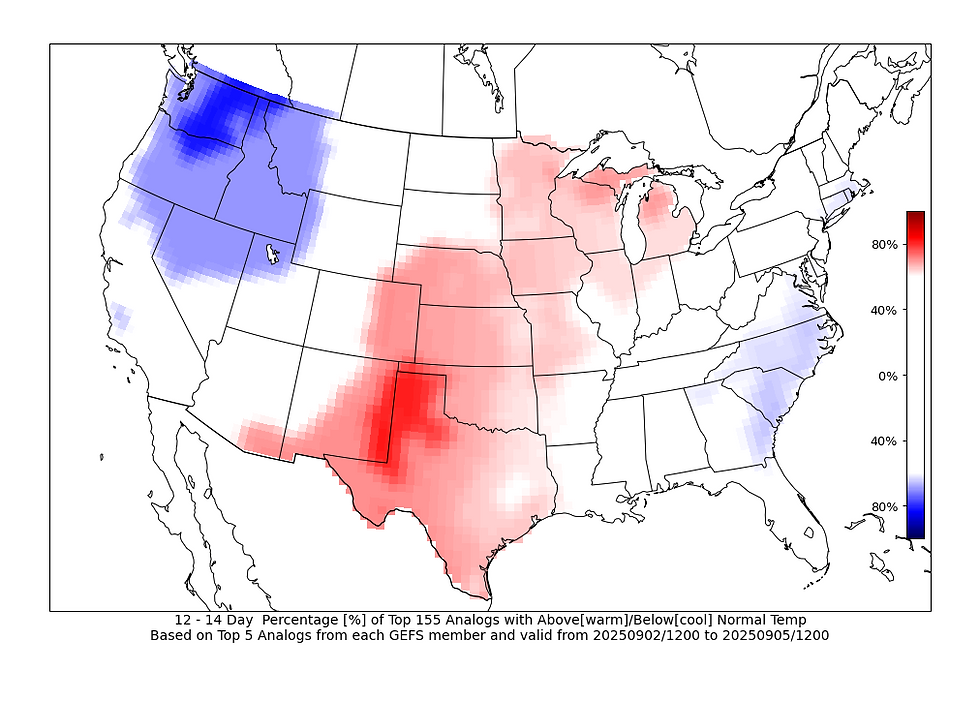
Analogs are showing a step towards warming temperatures as well, although the signal is not particularly strong at this point in time. I personally do think this is the likely scenario.

Analogs also are providing an 70-90% probability of temperatures back to at least 80 degrees in the Sept. 2-5 time frame. So again, I think the worst of the heat is behind us, but it's not like autumn has been cemented in place.

In terms of the precipitation outlook the faucet has really been shut off once we get through a few rogue storms Friday night. Below-normal precipitation is highly likely across the Midwest and Great Lakes region over the next two weeks. European ensemble guidance shows an outlook of precipitation being 1.5" to 2.0" below normal. That is quite a dry signal!

Most of the region could use a bit of a break from the rain. Virtually all of Iowa, Minnesota and Wisconsin are drought free as of the latest drought monitor update on Aug. 19. Much of the drought across northern Illinois was also neutralized after multiple rounds of heavy rain last week and early this week. The crops are looking good, but as we start heading towards harvest, saturated soils are not ideal and so we could use some dry time for sure.

Building on that, since June 1 a large portion of the area is having one of the wettest June/July/August periods on record based on preliminary data. Climate districts across Iowa are in the top five on record, with central Iowa in the top two. Northwest Illinois saw a big improvement in the short term with Iowa on the higher side for much of the period.
So, to summarize, cooler and drier weather is moving in through early September. Enjoy it! Have a great weekend,
-Meteorologist Nick Stewart


Comments