


POW, IT'S THE 1-2 PUNCH!
- Nov 25, 2025
- 5 min read
December is just a week away, and so far we haven't heard much from old man winter. But, just because he's quiet, doesn't mean he isn't up to no good. Rest assured, he's alive and well and ready to pay a personal visit. The long awaited pattern change is on the doorstep, and it's time to pay the piper.
THE INITIAL VOLLEY (Punch number 1)
By all accounts, Tuesday is your basic late November day. Nothing pretty to be sure, with a solid overcast and scattered showers in the southeast early. After departing, much of the remainder of the day sees low clouds and areas of fog. On the plus side, ahead of a strong cold front, the prefrontal draw should send highs into the low to mid 50s. That's a good 12-15 degrees above normal.

Late Tuesday afternoon, just ahead of the front, some additional light showers develop that quickly sweep east and end. Between 6 and 8 PM. the cold front hits and that's the end of the mild party. NW winds crank up, reaching gusts of 40-45 mph.

Accordingly, as the winds increase temperatures drop and by daybreak Wednesday, most spots are near or just below freezing. Wind chills have plunged into the teens.

Strong cold air advection will keep temperatures nearly steady Wednesday in the low to mid 30s, with strong winds continuing. It's likely that snow showers in the strong cyclonic flow behind the low spread across my northern counties. Some spots could see a nice dusting to 1/2 inch near HWY 20. Below is the EURO's depiction of the snow showers. Wednesday will be a very raw day as old man winter opens the door to the refrigerator.

Thanksgiving dawns cold and blustery, with temperatures in the upper teens to low 20s and winds chills as cold as 10. Some passing clouds and a few flurries are possible throughout the day, with highs generally in the range of 28 north to 35 in the far south. A fine day to eat, enjoy friends, family, and football, not necessarily in that order.
Black Friday sees lighter winds and some sun to start, however clouds increase again later in the day. After starting in the teens, high temperatures should end up around 29 north to 34 south.
GIVE THE GIFT OF MY 5 STAR AIRBNB IN GALENA

Holiday and winter specials are now in effect through March. Let us help you set up a personalized gift certificate that's sure to create a lifetime of memories! Santa Claus approved. Call or text Carolyn at 563-676-3320 for details and our very best pricing. https://www.littlewhitechurchgalena.com/
DOWN AND DIRTY, THE SECOND VOLLEY (Punch number 2)
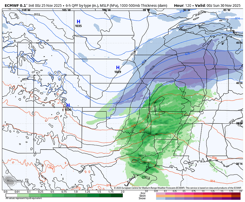
With cold air in place, the stage is set for the next system to bring the potential of accumulating snow. Modeling is not as consistent as I would like, but the EURO has been dialed in on a snow event for several days and due to its consistent solution I am leaning heavily on its output.
What the EURO shows is a mass of energy dropping into the Plains that generates an expansive trough and a Midwest centered vorticity max that produces a broad swath of over-running snows.

Moisture and lift look sufficient for a 24-hour period of snow that could deposit what could be heavy accumulations. The synoptic look on the EURO Saturday evening.
The ensembles of the EURO are rather robust for snow, suggesting 6–7 inches over the majority of my area, and the central Midwest for that matter.

The GEFS is not as excited and handles phasing and thermal profiles differently. Its amounts are more in the 2-3 inch range.

Where things get fascinating, is the EURO is much colder than the GFS. Sunday it has 850 temperatures at -10 to -11 C. The threshold necessary for snow is 0 C.

The GFS, with its less phased solution, has readings at the same time Sunday above freezing in all areas, leading to snow changing to rain. (Also, the amount of precipitation is much lighter). Get this, at Burlington Sunday, the 850 temperature is +6. On the EURO it's -10. That is a huge difference and major issue, and no doubt one of these models is off track by a long way, and I suspect it's the GFS. It's possible the EURO could change, but I really like the consistency it has shown in its solution, and I'm on its bandwagon.

Getting to the point, look at what the strong and colder solution does for snow totals on the EURO. Due to the cold air available aloft, snow ratios will be much higher than 10:1. That's the ratio I showed above on the ensembles. (They don't give me any other option). However, the deterministic models do, and using another formula which accounts for different ratios, has a more powdery snow and much higher "potential" amounts. The EURO is painting a snowy picture.

The GFS does have snow, but it changes it to rain, and notice how much lower the potential amounts are for the period ending noon Sunday.

As Nick and I are quick to tell you, we are not in the hype business. We show you what's on the table and advise you that we are still several days away and details remain unresolved. However, if the EURO is correct, and I think there is merit in its idea, this could be a significant travel issue on a major holiday weekend. I'm not afraid to say it's concerning, and I feel it's prudent to make people aware that a possible situation exists until waiting until the last minute to spring it on people. I would not change any plans yet, but I would recommend paying close attention to trends in the next 48 hours. If there is a reason to unplug the threat, so be it, and I will take it off the table. We should know in the next 24 hours how the wind is blowing this weekend.
The last thing I will mention is the EURO is far, far colder than the GFS over the weekend into next week. Snow cover in itself would keep readings colder, but even without it, the EURO's alignment of the jet delivers a shot of cold that the GFS does not. Notice the difference in temperature departures Sunday.
The EURO

The GFS

No doubt about it, there are some silos to unpack in the days ahead. While there is some uncertainty about the weekend, there is no doubt about the change to cold, blustery weather that will lead us into Thanksgiving. It's game on. Roll weather...TS
TSWAILS.COM expert weather consulting services (CLICK FOR MORE)

Private consulting
Legal forensic services as an expert witness
Public speaking engagements for groups or individuals
Post storm analysis
A private day-long weather school class
Specialized events forecasts
Severe weather seminars
Lectures and training
Climatological services
Meteorological workshops.


Comments