

SEARCHING FOR WINTER...
When temperatures are in the 60s like they were Monday, what do you do? I for one grab my fishing pole and hit the Swiss Valley trout stream outside of Dubuque. I fished the entire afternoon in a light sweatshirt without seeing a cloud in the sky. On top of that I caught my limit! It was just me, nature, and a 62 degree temperature, not bad considering a normal high is 48. As has been the case all fall, we're living on borrowed time with regular rounds of Indian Summer weather.
This latest surge of warmth has enough legs to support two more mild days with highs in the 60s Tuesday and the mid to upper 50s Wednesday. The cooler weather Wednesday is the result of a cold front tied to a weak clipper like system that dives across SE Iowa mid-morning. Dynamics are not great and moisture limited so the rain band (where it develops) looks narrow and on the light side. The EURO shows rain totals that are generally 2/10ths of an inch or less. The far south misses out entirely.

The biggest impact the disturbance will be its ability to deliver sharply colder temperatures. The animation below shows how the energy with Wednesday's system evolves into a deep east coast trough. On its backside, our air mass flips sources. Instead of a westerly flow coming in from the mild Pacific, it realigns to a northerly flow out of Canada.

As you can see in the 2 week EURO temperature trends, that drops highs into the 40s for 6 days November 12th through the 17th. Friday the 13th ( appropriately enough) shows temperatures going from 12 degrees above normal Monday to 5 or 6 degrees below normal Friday.

You can see the difference that's coming by comparing Monday's temperature departures to Friday's below.
Monday's departures.

Friday's expected temperature departures

If you go back to the 2 week temperature trends shown by the EURO, you will notice another strong push of mild air returns November 19th through the 22nd as we revert back to the westerly flow of the Pacific. The 65 shown on the 21st in the Quad Cities would be roughly 20 degrees above normal. But, that ends in a bad way with the EURO showing highs plunging to just 24 November 24th!
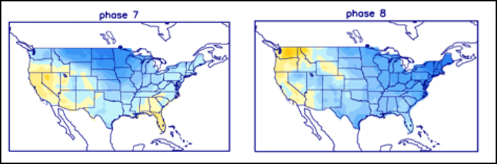
For the past two weeks, I've been highlighting the period from Thanksgiving into early December for a colder stormier look. Several things (aside from the El Nino) teleconnect strongly to such a pattern. Starting with the MJO (Madden Julien Oscillation), note that it jumps out of the warmth of phase 6, into 7 and 8 around November 21st.

In late November into December those phases correlate to below normal temperatures.
Additionally, The mean of the AO (Arctic Oscillation) is shown as being negative from November 21st through December 25th.

The mean of the NAO (north American Oscillation) is also negative for roughly the same period. Both are cold signals.

The PNA (Pacific North American Oscillation) mean and control is indicated to be positive through Christmas. The positive PNA is a colder signal for much of the eastern half of the nation.

We're are also experiencing a disruption of the Polar Vortex which often portels colder conditions (but not always) about 3 weeks later, roughly December 1st.
The compilation of these teleconnections leans heavily toward a colder pattern (assuming they are correct) from Thanksgiving into December.
In terms of precipitation, the means of the weeklies have a fairly robust footprint in that late November to Christmas time period over the balance of the eastern United States.

Also by then, temperatures at times will be cold enough to support snow if the mean of the weeklies pan out. This is what they show nationally for 32 day snow November 24 to December 25th. The interesting thing to me is how consistent the trends have been now going on 10 days. I absolutely can not guarantee what the weeklies show for amounts, but if you like snow, you should very much like the trend.

On that note, I sign off promising another very fine November day ahead. Again, if the long term trends verify, we won't be seeing many more of these 60 degree days. Savor them. Roll weather...TS.


Comments