


SOAKERS FOR SOME...
- May 2, 2024
- 4 min read
It wasn't all that long ago when many of us were begging for rain. It wasn't just a local problem, either. As recently as February 27th, 73 percent of the Midwest was in abnormally dry to extreme drought conditions. Some of the driest locations were noted in my far western counties in Iowa.

Spring rains began to work their way into the picture in March and really increased in coverage and intensity in April. These are the totals over the past 30 days. The NWS in Davenport is leading the way with 7.53 inches, with Burlington right behind at 7.51. Some areas around Macomb have had over 8 inches.

Through the heart of my area, (the spine of the Mississippi), 30 day totals are 2–4 inches above normal. East or west of that band, below normal amounts abruptly show up from Waterloo to Tama and a small part of Illinois, NW of Chicago. Here are the departures.

More rain is already on the radar and for some, another soaker is in progress. More on that and its duration below.
CHECK OUT THE 3 FOR 2 DEAL AT MY GALENA AIRBNB. CALL OR TEXT CAROLYN FOR RATES AND AVAILABILITY AT 563-676-3320

TERRY'S 5-STAR AIRBNB, WHERE VACATIONS ARE HEAVENLY (MAKE IT YOURS)

TSWAILS.COM, THE GUY DOES WEATHER RIGHT
MAY PICKS UP WHERE APRIL LEFT OFF
The recent trend of wet weather continues Thursday with a low pressure tracking through far NE Iowa. That has already caused a warm front to inch into the south overnight. The moist air advection has generated showers and a few thunderstorms in central Iowa overnight that enter my western counties Thursday morning. With time, these will continue lifting northeast along with the front through early afternoon. The way the energy and moisture is aligned, forcing is going to be greatest from the Quad Cities NW, and that's where the heavier rains are expected with this first wave of energy. In fact, it may take much of the morning for rain to creep east of the Mississippi, where it's shown rapidly diminishing in all areas by mid-afternoon. This is a simulated radar loop off the HRRR showing the progression of the rain from early Thursday to late morning Friday. You can clearly see the trend for the more concentrated and heavier rains in my counties west of the river in Iowa.

This single frame simulation from the above loop is time stamped for noon Thursday.

The 3k NAM is even slower, showing little rain east of a line from Iowa City to Dubuque by 3:00 in the afternoon. That may be a push and looks suspect to me.
Rain totals from numerous models do show some significant variance in amounts and location. There is a definitive trend for the higher totals west of the Mississippi, but even there, big discrepancies exist as to where the heaviest axis of rain occurs. This leads to low confidence as to overall rain amounts in any specific location, especially just a few hours before the event. Take a look, eastern Iowa is definitely favored for the more substantial rains, with amounts really tapering off east of the Mississippi.
The EURO

The GFS

The National Blend of models.

The HRRR

The 3k NAM

Highs Thursday are also showing large spreads from one model to the next, owing to the position of the warm front and the location of rain cooled air. I like what the HRRR is depicting, so that's what I'm leaning on. Here it is

One last shot at a shower or storm exists later Thursday evening as the cold front plows through. Then, much drier air arrives by Friday morning, with dew points crashing to the mid 40s. Dry air advection leads to plenty of sunshine, but highs that are a bit cool by May standards, in the mid 60s north to near 70 south.
Saturday, another fast moving disturbance approaches from the west. Clouds will be on the increase in the morning and a few showers are possible by late afternoon, especially over the west and south. The system will be fighting dry low levels and is expected to weaken the further east it gets. Other than the clouds, impacts look minimal, with plenty of dry hours and just light rain where showers develop in the afternoon. Highs will depend on the degree of overcast but should end up somewhere in the range of 65-70.
Sunday we are back to sunshine and with a reinforcing push of dry air, highs after a crisp start will make it back to the low 70s. An excellent way to end the weekend.
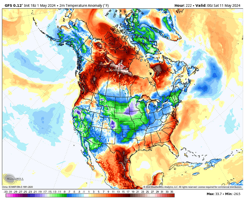
Looking into the future, the end of next week, long range guidance is showing a rather impressive 500mb trough building into the NC United States. If indeed it ends ups looking like this, it would open the door for well below normal temperatures for Mother's Day weekend. That's not a pattern we want to see this late in the spring.

These are the temperature departures it creates on the EURO, Friday, May 10th. Come on, I hope not!
Well, there you have it. Until we meet again, roll weather...TS


Comments