


SPECIAL POST ON HARSH WINTER WEATHER AHEAD...
- Feb 7, 2021
- 3 min read
LIMITED COPIES LEFT:
A SECOND PRINTING OF MY NEW BOOK IS ON THE WAY...

NEW COPIES OF DERECHO 911, IOWA'S INLAND HURRICANE ARE AVAILABLE. Around Christmas we sold the last of the 1500 copies of our book on this historic thunderstorm, the most damaging in U.S. history. Due to continued demand we ordered a limited number of 250 for those of you interested in having the most authoritative account of this extreme event. Books are selling fast so don't miss this opportunity to own the weather story of a generation. You can get yours at derechobook.com
I ordered one of your Derecho books about the storm in Cedar Rapids, IA back in December. I love it! I had also bought one that the Cedar Rapids Gazette sold. Your book by far is so much better, you have a lot more pictures and it just shows more. Thank you for putting a wonderful keepsake together! Do you have any left? If so can you tell me how to get at least one more.
Thank you so much! Penny Brecke
HARSH WINTER WEATHER AHEAD
From everything I have seen much of February, especially the next two weeks is going to be rough with strong potential for regular intervals of snow and cold. The stratwarm is in full bloom, the Arctic and North Atlantic Oscillations are negative and an extensive snow cover is in place. That's a recipe for cold and cold begets snow.
The AO

The NAO

Over the coming week the EURO depicts the average temperature to be 20 to 25 degrees below normal per day!

We kicked the cold off this morning with lows of 20 below in Cedar Rapids and 19 below in Davenport. Oelwein registered a reading of minus 22. At 2:00pm Sunday afternoon it's still -8 in Cedar Rapids with a wind chill of 21 below.

You can see the Arctic high that's delivering the cold planted right over the area.

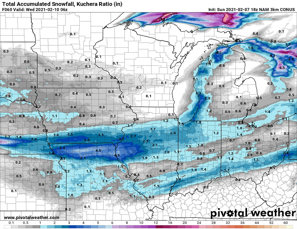
Minor disturbances will provide the lift for occasional periods of light fluffy snow the next 24 hours. Some of that has been found in the south today but a slightly more organized band is expected Monday that could deposit 1 to perhaps 2 inches of powder. Again, most of this should fall near and south of I-80. The 3k NAM shows where the potential exists.
Overall, the cold temperatures will continue but passing clouds will keep readings from crashing like they did Saturday night. However, any night where extended breaks in the clouds or un-anticipated clearing takes place, significant drops are possible that could yield lows of 10-15 below. We will need to watch that closely. A reinforcing surge of frigid polar air is due to arrive towards the end of the week. There are suggestions that lows could be back around 20 below Saturday morning. The GFS shows the threat with these lows Saturday.

The wind chills are really ugly as you can see below. The EURO is much kinder as it brings clouds and another snow system in from the west on Sunday producing warmer readings (relatively speaking). Plenty of time to figure that out.

As for snow, I don't see anything that's significant this week as the depth of the cold dry air keeps the heaviest accumulations just to the south. However, beyond that there are signs we get back into the action as evidenced by the ensembles of the EURO and GFS. Certainly a snowy look. By the way, these are 10:1 ration and at a minimum ratios should be more like 15:1.
The EURO ensemble control

The GEFS ensemble

I will leave you with this, the CFSv2 long range temperature outlooks February through May. Ugh, need I say more.
The rest of February

March

April

May

Any way you slice it, there's plenty of winter ahead of us the next couple of weeks and potentially well beyond that! Roll weather...TS


Really helpful post! One thing I was curious about do you have any advice for trendy hats for women? Would love to hear your thoughts.
In Ternopil, everyday needs are easier to sort out when https://www.link.ua/city/ternopol/ is used as a general city overview.
KASKUS288 KASKUS288 KASKUS288 KASKUS288
TOTO SLOT TOTO SLOT TOTO SLOT TOTO SLOT TOTO SLOT TOTO SLOT
TOTO SLOT TOTO SLOT TOTO SLOT TOTO SLOT
SLOT PASTI WD SLOT PASTI WD SLOT PASTI WD SLOT PASTI WD
SLOT PASTI WD SLOT PASTI WD
SLOT777 SLOT777 SLOT777 SLOT777 SLOT777 SLOT777 SLOT777
TOGEL TAIWAN TOGEL TAIWAN TOGEL TAIWAN TOGEL TAIWAN TOGEL TAIWAN
TOGEL TAIWAN
TOGEL ONLINE TOGEL ONLINE TOGEL ONLINE
TOTO TOGEL TOTO TOGEL TOTO TOGEL
SITUS TOTO TOGEL 4D SITUS TOTO TOGEL 4D SITUS TOTO TOGEL 4D
SITUS TOTO TOGEL 4D
SITUS TOTO SITUS TOTO SITUS TOTO SITUS TOTO
SLOT 4D SITUS TOTO
KARATETOTO KARATETOTO KARATETOTO KARATETOTO KARATETOTO
KARATETOTO KARATETOTO KARATETOTO KARATETOTO KARATETOTO
KARATETOTO KARATETOTO KARATETOTO KARATETOTO KARATETOTO KARATETOTO
SLOT 4D SLOT 4D SLOT 4D SLOT 4D SLOT 4D SLOT 4D SLOT 4D
SLOT 4D SLOT 4D SLOT 4D SLOT 4D SLOT 4D
SLOT GACOR SLOT GACOR SLOT GACOR SLOT GACOR SLOT GACOR
SLOT GACOR SLOT GACOR SLOT GACOR SLOT GACOR SLOT GACOR
SLOT GACOR SLOT GACOR SLOT GACOR SLOT GACOR SLOT GACOR
SLOT GACOR SLOT GACOR SLOT GACOR SLOT GACOR SLOT GACOR
SLOT GACOR SLOT GACOR SLOT GACOR SLOT GACOR SLOT GACOR
SLOT GACOR
SLOT GACOR SLOT 4D SLOT GACOR SLOT 4D SLOT GACOR SLOT 4D
SLOT GACOR SLOT 4D SLOT GACOR SLOT 4D SLOT GACOR SLOT 4D
SLOT GACOR SLOT 4D SLOT GACOR SLOT 4D SLOT GACOR SLOT 4D
SLOT GACOR SLOT 4D