


STEAMY TIMES INDEED...
- Jul 27, 2023
- 4 min read
The heat and humidity sent its first volley of thunderstorms into the region late Tuesday night and Wednesday morning. As expected, the action was focused on the north where some of the storms produced more than 1/2 inch of rain (which was very welcome). You can see the path of the storms and the rainfall they produced below.

One of the issues I've been concerned about with this round of heat is the impact storm clusters would have on temperatures if they developed. Debris clouds and outflow boundaries (mini cold fronts from rain cooled air) can alter thermal parameters. At noon Wednesday you can see the distinct markings of an outflow boundary sinking into EC Iowa from convection to the north.

At mid-day Wednesday behind the boundary Dubuque was at 78 degrees while near and south of I-80 readings were in the lower 90s where the air was undisturbed by storms.

Mesoscale details such as outflow boundaries can make make for some challenging forecasts due to the uncertainty of where they will form and travel. They are tough for models to foresee until storms have erupted. Additionally, if a model is projecting storms and they fail to develop due to capping issues, temperatures end up warmer. You can get burned both ways! In this case, despite the slow start the air mass mixed out and recovered sufficiently Wednesday afternoon in Dubuque to reach 93, the warmest day of 2023 so far.
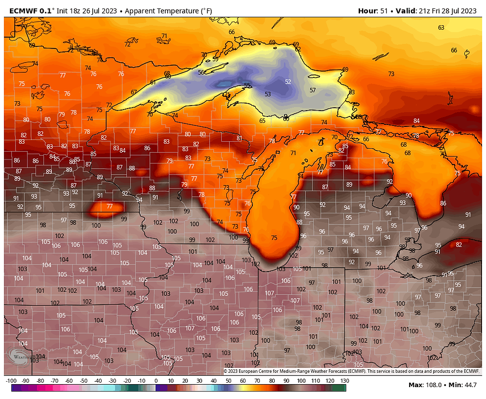
One thing seems straight forward about Thursday and that's the fact very warm air aloft is going to be in place. That should ensure a capping inversion which holds back the development of any storms despite plenty of instability. Thus, with ample sunshine it should be a very toasty day, potentially the hottest day of the year so far. The EURO has highs in the range of 93-96 from north to south.

Dew points again should be in the low 70s allowing the heat index to climb into the range of 101-106 degrees.

As a result, a heat advisory is in effect for all of my area Thursday (and Friday as well).

By the way, while highs are not likely to hit 100 they could come very close in the south both Thursday and Friday. A 100 degree reading would be a rare feat indeed as none of the major reporting stations in my area have hit the century mark in roughly 10-11 years. Here's the data on the last occurrence of a 100 degree high.

While Thursday is expected to be a dry day, scattered thunderstorms are possible Thursday night and again Friday night. The Thursday night set-up is far from certain as model consistency is all over the board. Currently chances are greatest in the north and even there odds are 40% or less. A formidable CAP and lack of a strong short wave are the big negatives. That said, if the low level jet can compensate for the short wave issue, plenty of instability exists for some healthy storms. Time will tell.
If storms fire Thursday night they are likely to fizzle Friday setting the stage for another warm sticky day. The EURO indicates highs again in the mid to upper 90s.

Heat index values are pushing 105 in many areas.
Towards evening a cool front descends on the north providing the forcing to fuel what could be some strong thunderstorms. CAPE (instability) is quite significant so there is ample energy for strong updrafts.

The EURO lightning flash density product shows concentrated lightning activity in my northern counties around 7:00pm.

SPC has much of the area in a slight risk of severe storms with the primary concern being strong winds Friday evening.

Water vapor is maxed out at over 2.00 inches at that time so very heavy rainfall rates of 1-2 inches an hour are possible in the stronger updrafts.

Friday night's storms are shown moving southeast out of the area early Saturday. In the wake of the associated cold front, cooler and drier are begins to make inroads into the region. The back of the heat wave is broken and a more seasonal brand of summer weather returns over the weekend. All hail the cold front! Roll weather...TS
SOME GREAT SUMMER DEALS REMAIN AT THE CHURCH....

NOW THIS IS "SPECIAL"
Hey everybody! I've got some openings the next few weeks at my AIRBNB, The Little White Church of Galena. I need to fill it up and that means I'm willing to deal. Contact us direct and we can eliminate the AIRBNB fees and taxes. That means big savings for you. Weekday rates are especially good. The newly remodeled church includes 3 bedrooms, 4 HD TV's, high speed internet, all in a beautiful country setting. All of our reviews are 5 STAR. There's no better time to enjoy Galena and all it has to offer. Split the cost with friends and family and we'll set you up with a deal that's as good as it gets. Call or text Carolyn at 563-676-3320 or email carolynswettstone@yahoo.com We would be thrilled to have you as guests!


Comments