


SUMMER WITH A CHANCE OF STORMS
- Jul 2, 2025
- 3 min read

If you have lived in the Midwest for more than a year or two, the next week (or more) is a pretty good benchmark for a normal summer pattern. Temperatures are pushing well into the 80s and 90s with a few chances for thunderstorms. The hottest day in the short term still appears to be the Fourth of July (Friday) with highs in the low 90s area-wide. The good news? Dewpoints will be high, but not quite as bad as it can be, so heat indices will likely avoid the triple digits. Still high enough to cause issues if you are not drinking water in addition to the adult beverages.

Temperature anomalies on Friday will run 5-10° across the local area, with the heat dome really centered over the Great Lakes. Northern Minnesota will likely see highs push 15° above normal on Independence Day!
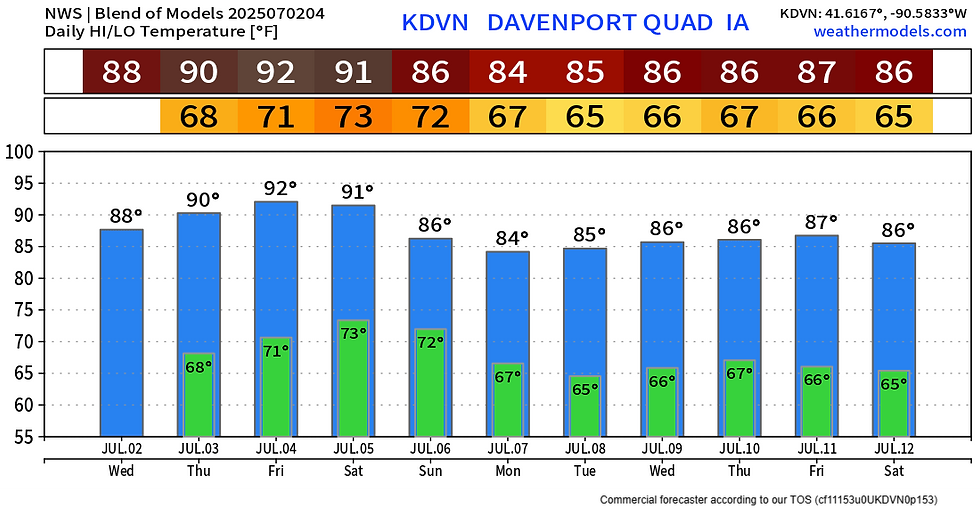
The model blend shows temperatures peaking on Friday with still some heat lingering Saturday ahead of a cool front that will knock temperatures and humidity down some, but also bring the risk of thunderstorms (some strong) that we have been discussing the last few days. Above-normal temperatures will continue into next week as well with 80s to near 90° temperatures in place.


Analogs and machine learning forecasts continue to indicate some potential for severe weather across the region Saturday, although the probabilities are somewhat limited for the time being indicating a low-confidence forecast. Formally there are no outlooks by the Storm Prediction Center, but this can still change going forward.

Before we get to Saturday, there will be some limited chances for a few scattered storms Thursday and Friday given the heat and humidity in place. The long-range HRRR model does indicate a few pop-up storms in the late afternoon and evening. Severe weather is possible with any thunderstorm that develops but it does not appear, at this point, to be a widespread concern.


The majority of the high-resolution models do show a threat for pop-up storms Thursday evening, but again it will likely be quite spotty in nature. Eastern Iowa into northern Illinois is likely the area to watch for this activity. Just like bubbles in a can of pop, you know they will be there but it's impossible to know where exactly they will develop and when.

Looking through June this is the area that certainly could use rainfall. While much of Iowa received some healthy rainfall, including 10" totals around Waterloo, the Quad Cities region couldn't top 5". In fact there were some 2" totals in northern Illinois through June. Typically to get the beneficial rainfall this time of year it comes in the form of thunderstorms, including severe weather, so it's not surprising the area has been pretty quiet on that front.

The map for tornado watches so far this year is actually quite wild. Portions of eastern Iowa have not seen a single tornado watch so far this year! That is a pretty rare feat to get through May and June without a watch for areas like Cedar Rapids and Iowa City, especially after that absolute chaos that was 2024. There is certainly quite a hole there in eastern Iowa.
So bottom line, it's getting hot and sunny headed into the weekend. There is a chance for isolated storms Thursday and Friday, with a risk of strong storms on Saturday for a more widespread area. Stay cool friends!
-Meteorologist Nick Stewart


Comments