THE ARCTIC HOUNDS ARE ON THE LOOSE....
- Jan 4, 2022
- 4 min read
January has gotten off to a feisty start, a complete turn around from the mild relatively snowless December preceding it. So far temperatures have not been above freezing but we might be able to get over the hump today as a short but welcome surge of warmth zips across the Midwest. Then it's quickly back to cold as the Arctic hounds run free.
Lows yesterday (Monday morning) were at their coldest levels of the season dropping below zero with a nice mantle of snow covering all of the area. You can see it clearly on the hi-res satellite with the areas in white indicating snow covered ground. Notice too that you don't have to go far to get out of it with the NW third of Iowa snow-free!

These were the snow depths reported by the NWS at 9:00AM Monday.

That snow cover also enabled Monday to get off to a frigid start. All of the region was zero or colder with Cedar Rapids as low as 13 below.

Here's a closer look at some of the readings in my area just before 6:00am Monday. In some locations readings went even lower over the coming hour as the cold dense air settled into the low spots before the sun was in full operation.

STILL A FEW SEATS AVAILABLE FOR WEATHER SCHOOL. TSwails.com is offering a very special opportunity for you to learn first-hand the ins and outs of weather forecasting with one of the most experienced meteorologists in the country and a talented team of experts. Get the agenda, details, and limited seats by clicking the banner below.
ALL IN ALL, A CHILLY PATTERN WILL DOMINATE THE FIRST THIRD OF JANUARY...
Despite a mini-warm-up Tuesday, the trend the rest of the week will be for colder temperatures to return. After highs Tuesday in the low to perhaps mid 30s far south, a strong cold front arrives late Tuesday night. After its passage, temperatures will hold steady or slowly fall and by Wednesday evening the GFS shows readings that look like this.

Wind chills will be back in the adorable range of 5-10 below before reaching 15-20 below overnight.

The combinations of renewed cold, strong winds up to 45mph, a few snow showers, and blowing and drifting of existing snow has prompted the NWS to issue a winter weather advisory for parts of my area from 9:00PM Tuesday until 6:00PM Wednesday. New snow will be little more than flurries or snow showers but the strong winds will blow around the powdery snow that currently exists causing low visibility at times, especially in the open country. That combined with wind chills up to 20 below will have the ability to create hazardous travel conditions. Here is where the winter weather advisories are in effect starting later Tuesday evening.

That leaves us with a very cold day Thursday. After lows down around zero most places will struggle to reach highs of 5 to 15 degrees from north to south.
Thursday night sees lows 10-20 below followed by another cold day Friday with highs barely above 10 degrees. In the meteogram below you can see another brief warm-up ensues Saturday only to be followed by another windy surge of cold air Sunday into Monday of next week. Also, don't be deceived by the highs shown Wednesday and Sunday. Those will occur before daybreak with falling temperatures during the day.

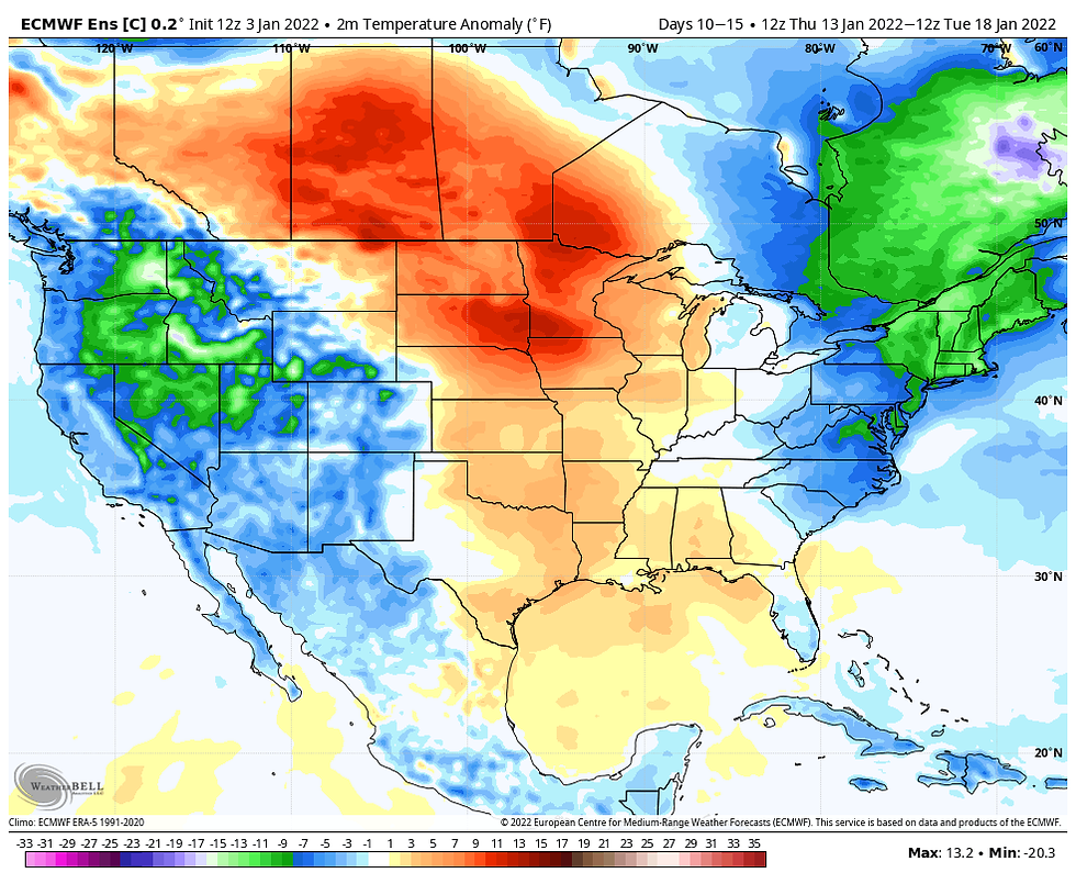
The major models are all showing good consistency with temperatures the next 7 days. However, week two readings are far more uncertain. The GFS is cold days 10-15 showing these departures.

The EURO is just the opposite with far warmer results.

I could see this going either way. Just a small difference in the position of the mean trough west or east could result in a significant range in temperatures. CPC favors the warmer look of the EURO and I think they are on the right track so I am leaning towards the warmer scenario of the EURO . Here's their 8-14 day temperature outlook. Time will tell.

One significant aspect of our weather that seems to be a lock will be the lack of storminess the next couple of weeks. The NW flow aloft will keep moisture limited. The storm track also seems to be absent of any clippers that might impact my area so it does not appear we'll be doing any shoveling in the near future. These are the projected precipitation totals depicted by the major long range models. Personally, I hate the overall lack of weather in the pattern but the consistency indicated leads to a high confidence, low precipitation forecast.
The EURO

The GEM

The GFS

With that I will call it a day. Enjoy the mini warm-up and roll weather...TS
PLEASE CONSIDER SUPPORTING TSWAILS...
Hi everybody, I'm asking that those of you who find value in the site to consider a $12 dollar voluntary subscription covering operating expenses and the time and effort I put into the site. My $12 dollar asking fee is the cost of a pizza or a dozen donuts. Those are gone in a day, TSwails.com is here for you all year long. It's a heck of a value and all I'm asking is that if you enjoy the site and see value in it, that you please consider a voluntary subscription. I'm asking $12.00 dollars a year. That's $1 dollar a month or 3 cents a blog. Thank you for your support and consideration. Terry


Comments