


THE CLOCK IS TICKING...
- terryswails1
- Sep 2, 2025
- 3 min read

Hi everybody, hope your holiday weekend was outstanding. Overall, the weather was great, getting better and better after we started with some wet weather Friday evening. It looks like we've got another stellar day on tap Tuesday before we transition into a much cooler pattern mid-week. The clock is ticking.
Speaking of cool, there's no denying the last week has been a crisp one for this time of the year. Much of the country has experienced below, to much below normal temperatures, with the Midwest and Ohio Valley leading the way.
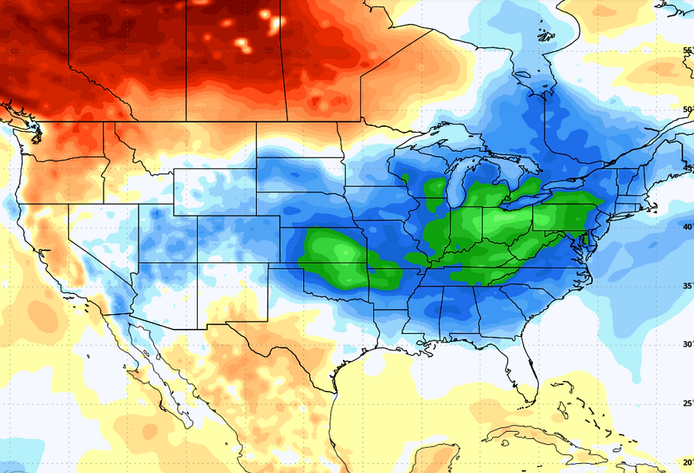
In less than 48 hours we're going to get another impressive shot of cool air that will be reinforced by a secondary surge later in the week. Look at the temperature departures expected over the 7-day period September 3-10th. That's even colder than what we just went through.

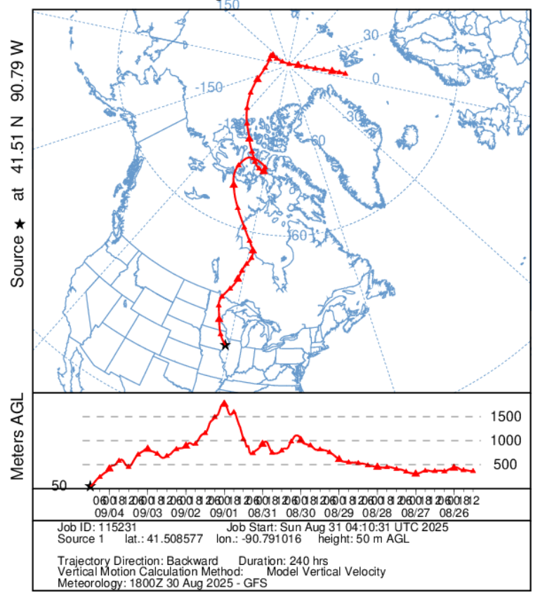
This is the jet stream pattern at 500mbs that plugs into the fall-like air mass.

In fact, if you follow the trajectory of the air mass from the Quad Cities, you can follow its origins centered on the North Pole. This is what the GFS sees as it back traces the upper levels winds over a 10-day period. We are quite fortunate it's not January 1st. Nick actually showed this process in his post yesterday, and it's very telling as to why temperatures will soon be going down.
PLAN A VISIT TO MY 5 STAR GALENA AIRBNB

My 5-STAR AIRBNB just outside of Galena still has some openings this summer. All of our ratings are 5 star! We take pride in the amenities and the cleanliness. If you book now, we'll take off $200, and we can eliminate AIRBNB fees and additional costs that will save you big bucks. Other discounts apply. Call or text Carolyn at 563-676-3320 for our best deal of summer. See more at https://www.littlewhitechurchgalena.com/
THE CLOCK IS TICKING...
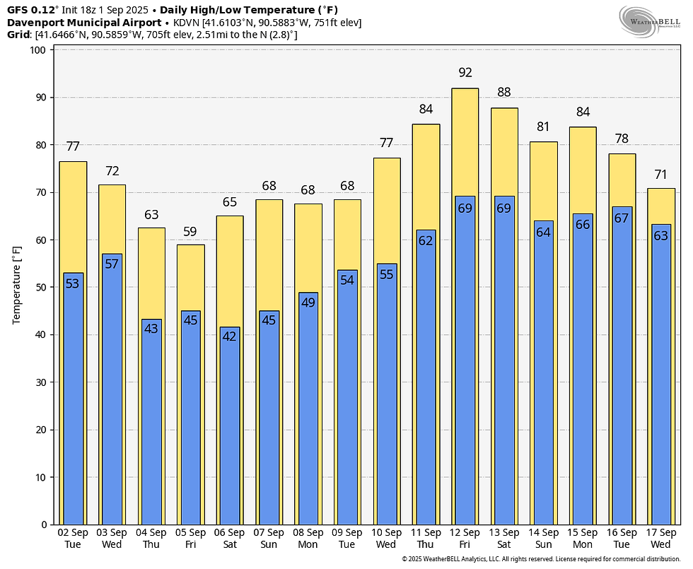
During the interim, we remain in the warm sector ahead of the advancing front Tuesday and at least part of Wednesday. We may see a bit more in the way of clouds Tuesday but should remain dry with highs reaching the upper 70s to near 80 south. Tuesday night the front makes its move on the area with increasing clouds and, despite meager moisture, some decent forcing for scattered showers and a few thunderstorms. Wednesday, thanks to stout NW winds, temperatures will remain in the mid 60s north to the mid 70s south where the cold air is slower to arrive.
Thursday, temperatures will be noticeably colder, and it will be blustery with some passing clouds. While fresh, the coldest air still lurks up to the north, where it will be released upon the passage of a clipper Thursday night. Highs Thursday should range from the low 60s north to about 70 in the far south.
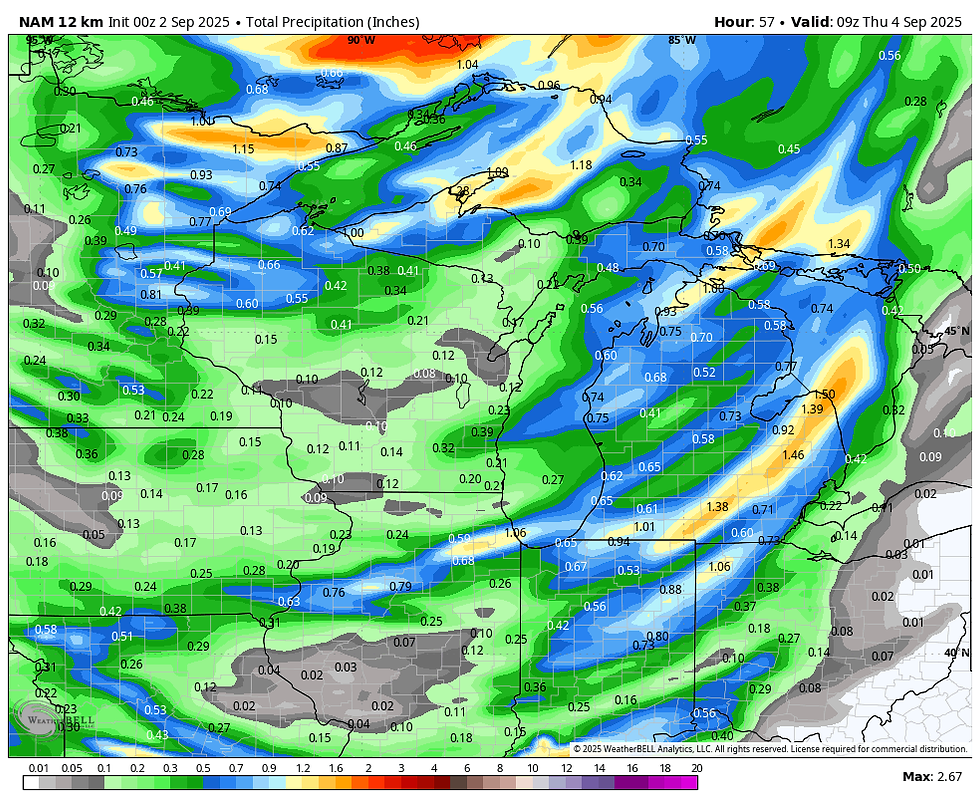
Thursday night, the clipper tracks over Iowa, producing another round of light rain or showers. The track varies considerably, with the GFS furthest south, allowing a nice band of over-running rain to impact my northern counties. It would also have the potential to keep readings a little colder Friday, particularly across the north. A track further north would imply slightly warmer readings across the board. Either way, some showers will sweep south Thursday night as strong cold air advection gets underway. It will likely produce some stratus Friday and may kick up a few showers, but the worst of the rain (which is not likely to be heavy) is over Thursday night. Between Tuesday night and Friday, here's what models are suggesting for rainfall.
The GFS

The EURO

The 12K NAM
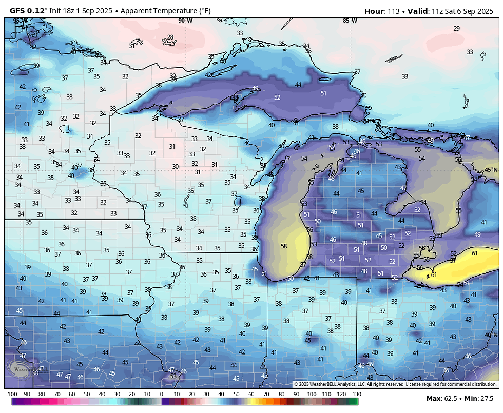
Blustery and cold conditions are a given Friday, with 850 temps just above 0C. That should drive stratus along with spotty light showers or sprinkles that will make for a raw early September day. The GFS shows highs Friday north of I-80 holding in the upper 50s. Low to mid 60s are expected further south.

Saturday morning, the potential is there for lows to be in the upper 30s in a few spots, but that will be dependent on decreasing winds and clearing skies. Here's what the GFS indicates. These are at record levels for the date if the GFS verifies.

Wind chills are projected to be in the mid to upper 30s areawide. How special!
The core of the cold air gradually shifts northeast Saturday, but highs remain chilly in the 60s. Sunday readings inch up a few more degrees but remain in the upper 60s to low 70s, roughly 10 degrees below normal. Towards the middle of next week, the GFS shows a return to summery temperatures, but I am highly suspicious of readings in the upper 80s to low 90s. We will be warmer, but I don't see anything as warm as the GFS indicates.
Well, there are some interesting changes coming that if nothing else will make my job a bit more challenging, just the way I like it. Roll weather...TS


Comments