


THE MOTHERLOAD...
- Sep 5, 2025
- 3 min read
In the weather world, timing is everything. Take Thursday for example. The day started crisp, with readings as cold as 40 in Cedar Rapids and Dubuque, with low 40s elsewhere. Later in the day, between systems', winds veered to the southwest and temperatures recovered into the mid to upper 60s, what I would classify as comfortably cool. Our timing was perfect as we remained in the sweet spot ahead of a strong cold front approaching from the northwest and another system that passed southeast of the region Wednesday. The arrival of Friday's front will be a game changer, bringing gusty winds and much colder readings come Friday night. The clipper that delivers the blow is evident Thursday evening, plowing south across Minnesota. Just look at the dynamic circulation that transports the chilly air. That is one impressive storm!

Thursday night, as the cold front passed, a band of clouds (and even some light showers north), will become a feature of our weather through September. By Friday morning, those will be long gone as a dry slot brings sun early in the day, However, strong cold air advection gets underway and by daybreak most areas will have experienced NW winds gusting 35-40 mph. These are the peak 10-meter wind gusts expected over the Midwest by 7:00am Friday. Gusts should decrease some by afternoon, although it will still be windy.

After the sunny start Friday, cold air aloft should create a fair amount of cumulus and some low stratus that may creep into the north late morning and afternoon. It's possible a few stray showers or sprinkles could develop, but they would be brief and amounts would be negligible. The north would be favored for any of these isolated showers.
As mentioned earlier, colder air will accompany the front, arriving Thursday night in the north and early in the day Friday across the south. Temperatures should start out around 50-54 Friday and only slowly climb into the upper 50s north, to the low 60s south on Sunday. After sunset Friday, readings will steadily decline, reaching lows Saturday morning of 40-44.
Lows on the GFS
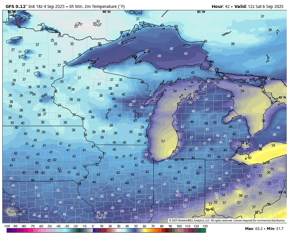
That's 17-22 degrees colder than 24 hours ago. A noticeable difference!

Wind chills Saturday morning will be the coldest in many months, going back to late April or early May. Actual lows in the Mid 30s to around 40 are likely around sunrise Saturday.

PLAN A VISIT TO MY 5 STAR GALENA AIRBNB

My 5-STAR AIRBNB just outside of Galena still has some openings this summer. All of our ratings are 5 star! We take pride in the amenities and the cleanliness. If you book now, we'll take off $200, and we can eliminate AIRBNB fees and additional costs that will save you big bucks. Other discounts apply. Call or text Carolyn at 563-676-3320 for our best deal of summer. See more at https://www.littlewhitechurchgalena.com/
OCTOBERLIKE THIS WEEKEND...
Beyond Friday, the core of the cold slowly lifts northeast, leaving us with a dry weekend. Pleasant days and crisp nights are anticipated. Highs in the range of 65 to 70 from north to south will be about 10 degrees below normal. Lows both days will be well into the 40s.
Next week, readings are expected to warm into midweek before another cold front drops readings again Thursday and Friday. Highs should be back in the 70s Monday and Tuesday with the possibility of an 80 degree high Wednesday, especially in the south. After that, another trough and chilly air takes aim on the region later next week.
One trend that's developed and looks to continue is dry weather. Since August 19th (a stretch of 18 days) rainfall in the Quad Cities has amounted to less than 1/4 inch (.23"). Here's what the GFS shows for highs the next 15 days. Many areas from I-80 north are shown with a nothingburger. It's not much better south of there.

These are the 2-week rainfall departures, and much of my area is 2 or more inches below normal, The whole Midwest is bone-dry. That should help the corn dry and mature if my farming knowledge is correct.

That's where we stand going into a Friday. After today's round of wind and cooler temperatures, the rest of the weekend should be nice, much like early October. Make it a darn good day and roll weather...TS.


Comments