


THE PENDULUM SWINGS HARD
- Feb 11
- 5 min read
A SPECIAL MESSAGE, I need your help to fund the site

I would like to thank the 269 people who have stepped up to the plate and made a donation to fund the site through this December. In the past year, TSwails had over 600,000 sessions, meaning less than 1 donation per session. If you do not find value in the site or don't have the funds, I understand and still welcome you with open arms. For those of you here daily, who gain knowledge, or make financial decisions based on the information, I ask that you make a reasonable contribution. Every little bit helps. After much deliberation, I've decided that due to the daily commitment of time, money, and hard work, this will be the last year for the site if I don't reach my financial goal. I'm 72 percent there. The future depends on you. Thank you for your consideration and support the past 13 years. T. Swails
AVERAGES ARE COMPRISED OF EXTREMES
The Midwest is and always will be a place of weather extremes; our unique climate will see to that. It's not out of line for us to see a 120-degree range in temperatures in any given year. The greatest historical temperature range in Iowa spans 165 degrees, with Keokuk reaching 118 degrees in 1934 and Elkader dropping to 47 below in 1936. In 1996, Iowa temperatures went from 47 below in Elkader on February 3rd, to a high of 63 on February 9th. That's a swing of 110 degrees in 6 days! You get the point.
Here's a look at each state's hottest and coldest temperatures.
The Coldest

The hottest

While we're talking extremes, the high temperature on Monday in Sioux City was able to reach 75°F, which beat the record high for February 9th by a margin of 13 degrees! It's considered quite a feat to beat any record by 5 degrees, let alone 13.
That bodes well for our future, as the long stretch of cold temperatures in the region has finally broken. Here in Dubuque, we went 19 days without reaching freezing. That doesn't even come close to the record, which was 52 days in the great winter of 1978-79. However, it is the longest stretch since 2009 (17 years ago).

The recent warmth has decimated what little snow cover there was around the region. The graphic below shows the areal percentage of a 1" snow depth over Iowa. Most of the state was covered from November 28th to December 13th. Yet, since Christmas, no more than 45 percent of Iowa has been covered. Today the number is zero. The proverbial goose egg.

As of Tuesday, you can see plenty of snow remains over the upper Midwest and much of the Great Lakes. There is none from Iowa west and south.

The lack of snow cover will be a major factor in the warming that is projected to surge into the region. The bare ground will not reflect the sun's energy, allowing it to be fully absorbed. Throw in this upper air pattern early next week, and we are golden for some real springlike temperatures.

Keep in mind normal highs next week range from 30 to 35 from north to south. The GFS is showing departures that are a solid 35 degrees above that.

NOAA indicates the odds of temperatures being above normal are 60-80 percent in its outlook for temperatures February 15-19. That makes me giggle, and I'm not a giggler. I mean, come on people, don't stick your neck out.

The EURO doesn't have a day approaching normal from today through the 20th, a stretch of 9 days. I'd bet on it.
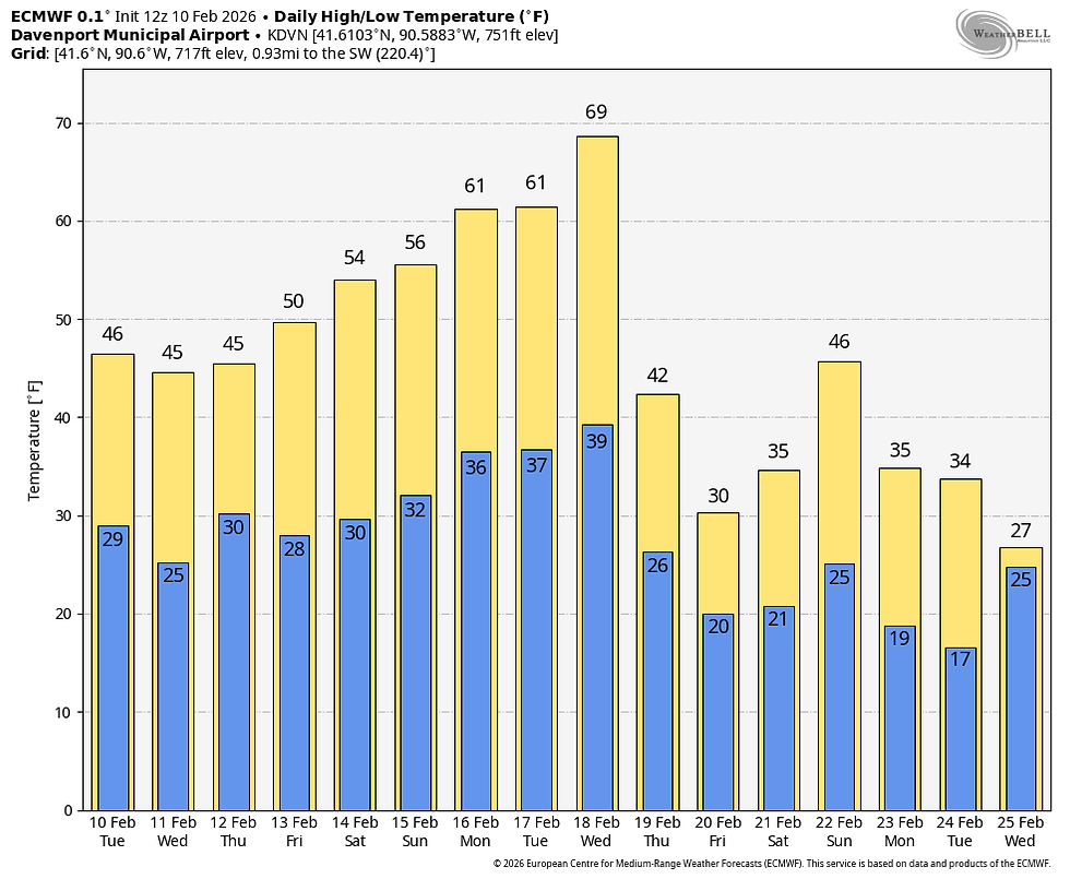
The GFS is even a few degrees warmer than the EURO and extends it a couple of days longer.

I mentioned this in my previous post, and it's worth bringing up again, especially for my northern counties. Look what the EURO does with its highs on the 19th.

It shuts the warmest air down about I-80. Most likely this is due to the cold waters of the Great Lakes and the snow cover that surrounds them (see the snow depth graphic above). The warmth has a very tough time bucking the cold, dense air at the surface and pretty much stalls over southern Iowa and WC Illinois. I've seen this numerous times in situations such as this. It's a real thing, and models can have a tough time gauging the effect. Hopefully it doesn't force the boundary any further south in future runs. Again, the lack of snow cover up to Wisconsin should help our cause, but it's early February, and things would have to go very right to get highs up to 65 in my southern counties.
Anyway, I'm feeling really solid about our steady warm-up late week into the weekend, which crescendos into the range of 60-65 early next week. However, the WPO (Western Pacific Oscillation) should put a fork in it no later than the 19th. It goes from 3 standard deviations above the mean to more than 2 below at that time. In essence, that forces a ridge to form in the Pacific that should seed colder air into the Midwest weather pattern.

The transition could very well be the catalyst for a healthy storm on the 18th. You can see the various members of the EURO ensembles clustering around a deepening low in NW Iowa. Preceding the system, the warmth that we've discussed is being pumped into the Midwest.

The hope is that enough moisture will be ingested to produce some needed rains in the warm sector where we reside. What I don't like is the way the EURO is depicting the precipitation structure. The way the low tracks a dry slot comes right up over eastern Iowa. That's not the spot to be in if you are looking to get worthwhile precipitation. We just haven't had any luck locally getting into a wet system since the Thanksgiving weekend storm (more than 2 months ago). You can see precipitation surrounds us but won't attack us. In general, the pattern is more energetic and has already produced a couple of wet events, but we can't seem to hit. We still have opportunities in late February and early March, so I'm not throwing in the towel, but this persistent trend is disappointing.

For what it's worth, the EURO weeklies show this for rainfall through March 28th. A hopeful sign.

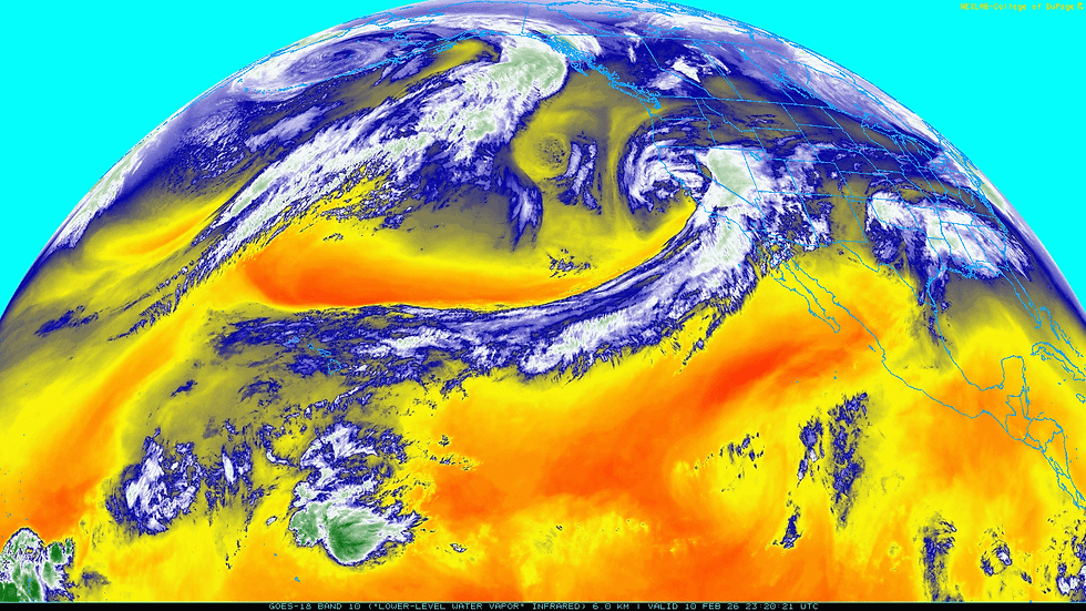
I'll leave you with this GOES West satellite imagery. There's energy and storms galore, and look at the atmospheric river that's raging from Hawaii to California. That's what will drive our warm-up the next week and hopefully get us into a stormier pattern beyond that. Churn baby churn!
That will do it for now. Have a rock-solid day and roll weather...TS ON A SERIOUS NOTE, IF I DON'T MEET MY FINANCIAL GOALS, THIS WILL BE THE LAST YEAR OF THE SITE. IF YOU LIKE THE CONTENT, THE FUTURE IS UP TO YOU. T.S. 72% to my goal.


Comments