


THE TRICKS OF THE TRACK
- Mar 26, 2024
- 4 min read
We've had a couple of healthy storms roll through the Midwest the past 5 days. Due to the track of the individual events, we've seen large variances in temperature, precipitation types, and amounts. In almost every case, the low pressure center played a major role, with the cold sector northwest and the warm sector to the southeast. Often times, the circulation center contains the weakest forcing (like the eye of a hurricane), and its track is evident by the lack of precipitation that falls along its path. This is known as the dry slot, not the place to be if you are looking for a good rain or snow. Above all, for a forecast to be a success, you need to nail the track!, Fail, and you can watch everything disintegrate before your eyes. That makes for a very bad day! Not that I would know, says the joker....
With last Friday's system, the track focused precipitation more on central Iowa and northern Illinois. You can see the snow that came of that. A secondary band cut through central Minnesota and Wisconsin.

The current system, tracking northeast through central Iowa, produced its forcing and cold air from far NE Iowa into Minnesota and the NE half of Wisconsin. Some big snows were the result of that to the northwest. Combine the two events, and some places in central Minnesota and Wisconsin have had nearly 18 inches of snow the past 5 days.

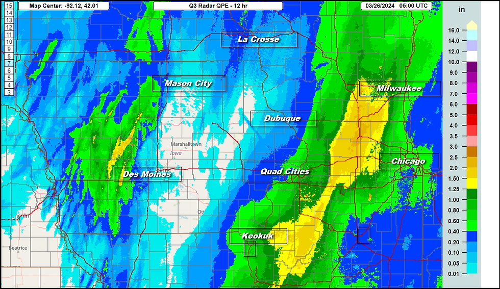
Each storm has also produced rain in the warm sector. If you look at the liquid equivalent of the snow and rain combined, it is evident that the primary storm track was either NW or directly over my southern counties. The heavier totals occurred near and NW of those tracks. This graphic shows precipitation amounts Friday through 7:00am Monday.

What you can't see beyond that is the feed of subtropical moisture that is driving a heavy rain band that catches parts of my region, especially my counties in Illinois. The major storms, like we are witnessing now, usually produce this eastern wing of rain as divergence in the upper air pattern slingshots the low level jet northeast ahead of the primary energy.

The end result of such a set-up is that a soaking rain of an inch or more falls in my eastern counties, while the further west you go from the Mississippi, lighter amounts are found in eastern Iowa with the dry slot coming into play. It keeps amounts showery and much lighter in that part of my area. Unfortunately, that's a zone that could have used the heavier amounts most.
These are the additional rainfall amounts shown on Doppler through late Monday night. You can clearly see the low pressure track up through eastern Iowa by the lower totals there. Add these totals to those above through 7:00am Monday and much of the Midwest picked up some much needed rain.
The final issue to watch Tuesday is wrap around moisture and much colder air that swirls in behind the advancing storm. A strong cold front enters my NW counties toward daybreak, crossing the Mississippi around midday. Falling temperatures into the 30s can be expected NW of the Quad Cities in the morning before impacting the southeast in the early afternoon. By 9:00pm Tuesday evening, temperatures are below freezing in the upper 20s to low 30s, 20-25 degrees colder than 24 hours earlier.

Even worse, wind chills in the north are well into the teens.

It won't amount to much, but some late afternoon or evening snow showers are also expected in the NW, especially NW of a line from Iowa City to Dubuque. A dusting is possible in the heavier squalls. Hopefully, that will be the last time we see flakes this season.
5-STAR AIRBNB, WHERE VACATIONS ARE HEAVENLY (MAKE IT YOURS)

TSWAILS.COM, THE GUY DOES WEATHER RIGHT
GRADUAL WARMING AS THE WEEK WEARS ON...
With the storm departing and NW flow invading, temperatures will remain well below normal Wednesday, ranging from 40 north to about 50 south. Thursday warm air advection commences and could spark a few showers on a warm front in the north towards evening. A pretty healthy spread of temperatures is expected, with highs near 50 north to about 60 south. Friday, with the warm front north of the region, a mild dry day is anticipated with highs well into the 60s in all locations. Nice!
The coming weekend, which includes Easter Sunday, appears to be fairly average, nothing great but certainly nothing awful. Saturday comes in dry and mild. Easter Sunday is fine and dry on the GFS but not as pleasant on the EURO with a chance of rain in the south and more in the way of clouds. I would not be surprised if later runs show a better outcome than what is currently indicated on the EURO. That will be a focus of later forecasts. Meantime, that is what I have for now. Until next time, roll weather...TS


Comments