


TIRED OF EATING SOUP...
- Jul 29, 2025
- 4 min read

If you're tired of our diet of soupy weather, there's a good reason why. As of Tuesday, the NWS in the Quad Cities indicates the Davenport office has experienced at least 1 hour (or more) of dew points 65 degrees or higher 47 consecutive days. That is the longest streak since the ASOS era began back in 1997, or 28 years ago. ASOS stands for automated surface observing systems. A dew point of 65 is when low level moisture reaches the point where it begins to get uncomfortable. From there it only gets worse, especially after 70 when the scale goes to oppressive and finally miserable at 76 and beyond. We've seen a multitude of those days.

From the looks of things, the streak reaches 48 days before much cooler and drier air settles in on Wednesday evening, dropping dew points into the 50s Thursday through the coming weekend. This is a significant pattern change that weakens and forces the persistent heat dome west and south, allowing NW flow to set up shop at 500mb. The jet stream pattern goes from this Monday.

To one that looks like this next Monday.

Water vapor goes from extreme levels greater than 2 inches Tuesday.

To about 6/10ths of an inch Sunday morning. That's a substantial drop in low level moisture.

So much so that dew points in Davenport are shown at 46 degrees at 6:00am Saturday morning, a drop of 30 degrees from what we'll still be seeing Tuesday.
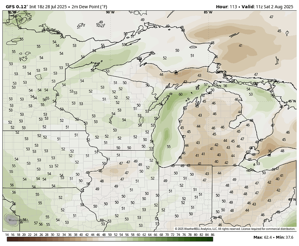
The GFS even shows lows in the low 50s Saturday morning. What a way to kick off August.

IT'S TIME TO VISIT TO MY 5 STAR GALENA AIRBNB

My 5-STAR AIRBNB just outside of Galena still has some openings this summer. All of our ratings are 5 star! We take pride in the amenities and the cleanliness. If you book now, we'll take off $200, and we can eliminate AIRBNB fees and additional costs that will save you big bucks. Other discounts apply. Call or text Carolyn at 563-676-3320 for our best deal of summer. See more at https://www.littlewhitechurchgalena.com/
HEADED TO A JOYOUS PLACE
Before we get to that joyous place, we still have some weather to fight through the next 48 hours. In fact, as I write this post late Monday night, I'm trying to envision the impact of overnight storms that will be exiting by early Tuesday. An intense thunderstorm complex that formed in South Dakota and NW Iowa has been marching southeast along an instability gradient laid out across Iowa. With plenty of CAPE, healthy deep layer shear, and a sufficient cold pool on the nose of a jet max, these storms have the capability to sustain themselves in a strong to potentially severe mode though daybreak Tuesday. Much like Sunday night in the northern half of my area, strong winds may accompany the mature MCS as it plows southeast before weakening early Tuesday. This mesoscale discussion from SPC after midnight Monday, shows the developing MCS entering my NW counties in Iowa with wind gust potential of 55 to 70 mph. What remains of that line could be problematic for a small part of my area in EC Iowa and NW Illinois though daybreak.

As a result, SPC has an enhanced level 3 risk outlook of severe weather that catches some of my NW counties west of a line from Cedar Rapids to Manchester and the NE tip of Iowa.

The primary risk is damaging winds if the line can hold together through the night as it comes east. A 15 to 44% risk of damaging winds within 25 miles of a point is shown just NW of the Quad Cites into much of EC Iowa. If strong winds occur, I think they end up being confined to my counties in Iowa west of the Mississippi.

A refined assessment, based on radar trends around 2:30 am, points to the SW half of my region in Iowa as being under the greatest risk to see these storms in a formidable way. The area east of the Mississippi may see little if any in the way of rain or storms as they hit a more stable environment and hopefully turn south and weaken towards daybreak.
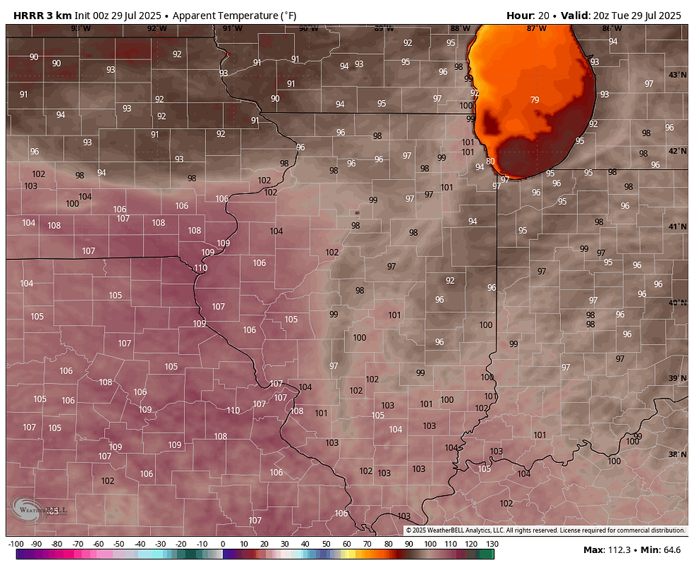
Where storms occur, they will be fast moving, and that means the majority of the area is storm free by 7:00am Tuesday. The departure of the MCS will likely leave subsidence much of the day and may even mix out dew points a bit. Most areas are likely to stay dry all day. Additionally, the north may avoid another day of intense heat, while the south is not so lucky. These are heat index values shown on the HRRR. It's another burner south of I-80 with heat index numbers of 105-110. North of HWY 30, Monday night's storms keep things more manageable around 91-96.
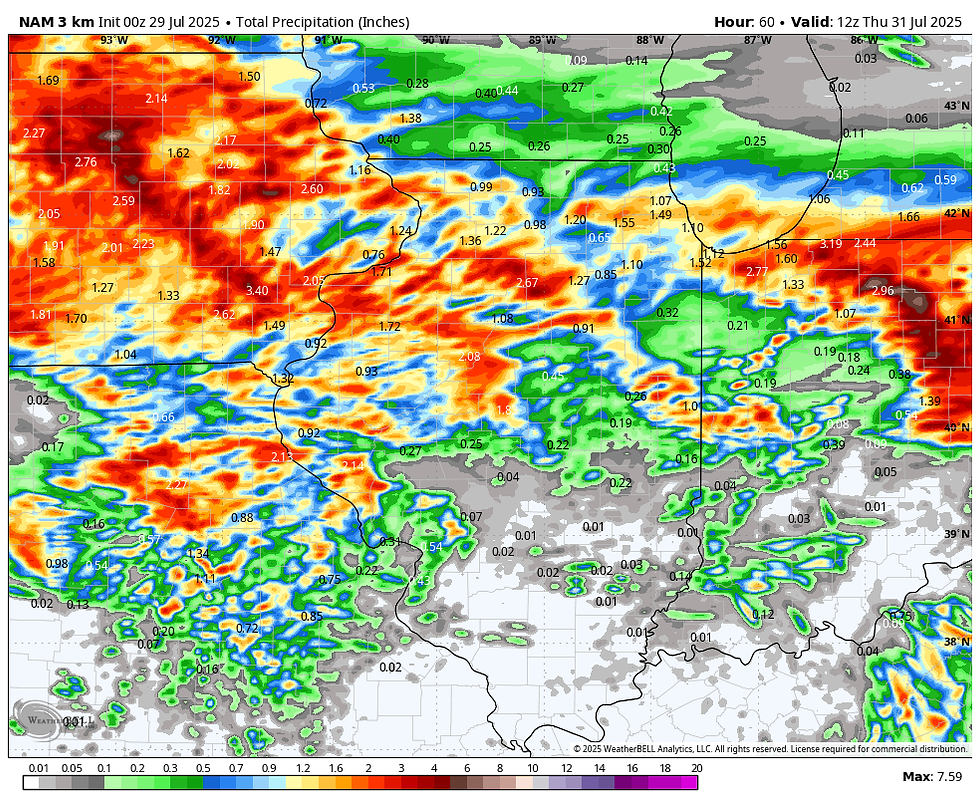
With the front still wandering around, the baroclinic boundary for additional showers and storms is in place Tuesday night and Wednesday. The primary concern for this round of energy is for locally heavy rains and the potential for flash flooding or river flooding in time. Here's what models are suggesting for total rainfall tonight through Wednesday night, with the majority of the amounts shown, falling late Tuesday night and Wednesday.
The EURO

The GFS

The 3k NAM
The HRRR

Finally, the front clears Wednesday night and we can stop eating soupy weather. Notice the GFS shows 7 consecutive days of highs in the 70s to start August. I don't have the facts on what the coolest first week of August is, but my educated guess would be what the GFS indicates is top ten in about 140 years of records.

On that note, it's time to move on and closer to that sweet weather headed our way later in the week. We deserve every degree of it. Roll weather...TS.


Comments