


TURNING UP THE TEMPS...
- Sep 9, 2025
- 4 min read
If there's one thing I'm certain about, it's the fact temperatures the past 15 days have been exceptionally nice, more reminiscent of early October than late August and early September. Take a look at the lows here In Dubuque since August 24th. 9 of the last 15 days have been in the 40s or colder, with one morning as cold as 39 degrees.

Further south in the Quad Cities, it's not been quite as fresh but still very much on the cool side, with 8 of the last 15 days in the 40s or colder

Here's the overall temperature departures for the past week (7 days) showing the coolest readings relative to average, centered squarely over the Midwest. Most of us averaged 10–12 degrees below normal per day over that 7 day stretch.

The 39 degree low Sunday morning according to my climate guru Steve Gottschalk was the earliest for a temperature in the 30s at his place in Lowden, Iowa since 2011. Steve tells me he has only registered 6 other years with lows in the 30s this early in the season. The other times were 1960, 1962, 1974, 1986, 1988, 1997, and 2011.
I asked Steve how the following winters turned out in those years to see if there was a correlation. Here's what he came up with in his research....
1962/63, cold and snowy
1974/75, normal and snowy
1986/87 warm and less snowy
1988/89 warm and less snowy
1997/98 warm and less snowy
2011/12 warm and less snowy
Essentially, 4 out of the 6 years had above normal temperatures and below normal snow. Using the methodology of temperatures in the 30s before September 8th, there's a 66% chance (2 out of 3) that our winter will be mild and less snowy. I'm still working on my winter outlook but if anything, the trends I'm seeing to date have me leaning the opposite direction towards a colder winter, which would certainly improve chances of at least normal snowfall. Maybe this winter will be one of those 33% seasons? More on that in 2–3 weeks.
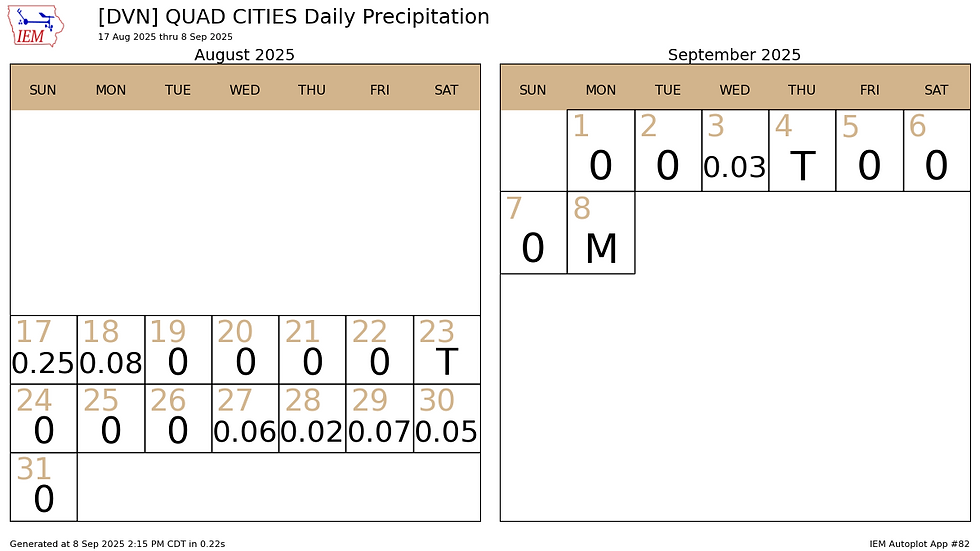
Another special aspect of our recent nice weather has been the lack of precipitation. Going back to August 19th in Dubuque, only .11 inches of rain have fallen over that 21-day period. Talk about shutting off the switch!

The numbers are a little better in the Quad Cities over that same 21-day period, but not by much, with the NWS office in Davenport measuring just .23 inches.
We've seen the worst of this cool snap as we undergo a pattern change that allows a warmer air mass to make its way back into the Midwest. Notice how upper level winds at 500mb had been strongly out of the northwest over the weekend, transporting crisp dry air into the middle of the nation.

Come Saturday, September 13th the 500mb flow looks entirely different with a ridge centered over southern Missouri.

That type of upper level ridge in that general area in July and early August brought us some of the hottest and muggiest weather of the summer, with dew points up around 80. Neither the EURO nor GFS shows moisture levels that high, but the GFS is exceptionally low for such a pattern, with dews in the 50s and low 60s. The EURO brings a couple days of mid to upper 60 dews which seems more likely before breaking the pattern down early next week with the passage of a cold front and cooler temperatures. The EURO shows 3 very warm days ahead Friday through Sunday and then the cool-down. I could see the warmth lasting a couple more days than shown before breaking down. Its latest run shown this.

The GFS on the other hand holds the ridge staunch for nearly 2 weeks and smokes the area with 10 to 11 days of highs in the 90s. I'm thinking the reason it is so hot is the lack of moisture and dry soil conditions due to the recent lack of rain. It shows a brutal stretch of hot and mainly dry weather, and it looks like this, with 3 days of highs 97 to 98.

I can see 4–6 days of highs 85 to 91 later this week into Tuesday, but after that I think the EURO'S return to a more reasonable and seasonal level makes far more sense, especially considering we'll be in mid-September. That said, it could very well be too fast with its cool-down Monday, and may take a couple more days than what's shown. I will be very surprised if the GFS comes close to verifying, and I think its idea of a prolonged period of extreme heat is way off base. I am definitely in the EURO's camp, long range, but stress next week's temperatures are low confidence at this point in the game due to model discrepancies.
Whatever happens, we are going to steadily increase temperatures the remainder of the week, with most spots in the 80s by Wednesday and the low to mid 80s Thursday and Friday. Saturday has the potential to be the warmest day, with 90-92 possible in the far south. That's a pretty good jump from those 39 degree lows this past Sunday.
As far as precipitation goes, Tuesday should be another dry day, although we should see more in the way of clouds due to increasing warm advection. That process may even generate some showers Tuesday night that carry into Wednesday morning. With so much dry air in place initially, it will be tough to get much in the way of rainfall out of this set-up. Maybe 1/10 of an inch in spots, with others remaining entirely dry. These are the rain totals suggested by models Tuesday through Wednesday night.
The EURO

The GFS

After that, warm and mainly dry weather takes over through Saturday. Some convergence Saturday night or early Sunday from the front the EURO sees, brings another shot at some showers and perhaps storms then. This is the front that should put the kibosh on the heat early next week. Let's hope so.
With that, I will call it a day with the anticipation of summery temperatures to come later this week. Roll weather...TS


Искусственный интеллект все чаще используется в индустрии онлайн казино, особенно в области выявления угроз. Используя алгоритмы машинного обучения, лучшие казино могут отслеживать активность игроков в режиме реального времени, выявляя подозрительное поведение, которое может указывать на мошенничество или другие нечестные действия. Эти системы обучаются на больших массивах данных, и их адаптивность делает их чрезвычайно эффективными.
Mobile video creation continues to move away from desktop software, and many creators now rely entirely on their phones. Capcut APK is often mentioned as a practical solution for Android users who want speed without sacrificing quality. With Capcut APK, creators can trim clips, add transitions, and sync audio in a single workflow that feels natural and efficient. The interface is designed to reduce friction, allowing ideas to move quickly from concept to finished video. Capcut APK also supports modern social formats, making it easier to produce content that fits platform requirements. This shift toward mobile-first editing reflects a broader trend in content creation, where flexibility and portability matter more than complex setups. For many creators, editing on a phone…
“TURNING UP THE TEMPS...” sounds like a powerful and timely discussion, especially in today’s climate-focused world. Exploring the impact of rising temperatures, sustainability, and energy efficiency is essential for both businesses and individuals. Just like adapting to environmental changes, industries also adapt with technology. For example, embroidery digitizing usa services help companies stay competitive by offering precise, high-quality digitized designs for branding, apparel, and promotional products. Reliable digitizing ensures efficiency, minimizes errors, and enhances presentation. Whether it’s addressing climate challenges or delivering professional embroidery, innovation and adaptation remain the keys to long-term success. Great topic for deeper exploration!