


WELL, WASN'T THAT SPECIAL
- Nov 11, 2025
- 4 min read

Well, what a crazy weekend of weather. If you are a fan of variety, you should be more than pleased. We went full circle, with highs Friday in the 60s to wind chills by the end of the weekend that were in the single digits and teens. (In just over a day, it felt 50 degrees colder). On top of that, sunshine Friday gave way to rain Saturday that in many areas changed to snow Saturday night. While most of us experienced snowflakes, accumulations were generally no more than a dusting north of I-80. There was an exception though in parts of EC Iowa and NW Illinois where 1–2 inches of wet snow coated everything but the roads. As the church lady would say, isn't that special!
Here's some snow reports thanks to the Iowa Mesonet and its developer Dayrl Herzmann.

This larger perspective shows there were two pockets of snow, one that left up to 5" in the northwest half of Iowa. The other picked up again near Dubuque, with King, on a ridge just southeast of the city, reporting 2 inches. From there it spread east and dumped 4 inches in Monroe, Wisconsin, just north of the Illinois border. Last but not least, Lake Michigan Lake effect snow hammered SW Michigan and NW Indiana Sunday into Monday with up to 14 inches at Walkerton, about 20 miles from South Bend.

The NWS in Chicago produced this recap of the snow near them with 1.7" at O'Hare and 2.5" at Midway.

After the clouds departed Monday morning, the visible satellite image clearly shows snow on the ground in NW Iowa and extreme EC Iowa into NW Illinois. You can also see an ongoing snow plume cutting through Lake Michigan into NE Illinois.

By the way, some very needed precipitation fell Saturday, especially in a west to east corridor from I-80 to north of HWY 30. Amounts of 1/2 to just under an inch were found there. Clinton, Camanche, and Park View all picked up about 8/10ths of an inch of liquid precipitation.

The icing on the cake was the cold that greeted Midwesterners Monday morning. Spencer, in northwest Iowa, with the aid of a 5-inch snow cover, plunged to a low of just 6 degrees. In my area, Cedar Rapids and Clinton were the coldest with minimums of 19. A late report from Lowden indicates 18 there. Time to take a deep breath.

GIVE THE GIFT OF MY 5 STAR AIRBNB IN GALENA.

Holiday and winter specials are now in effect. Let us help you set up a personalized gift certificate that's sure to create a lifetime of memories! Santa Claus approved. Call or text Carolyn at 563-676-3320 for details and our best pricing. https://www.littlewhitechurchgalena.com/
This is certainly a harsh reminder of where things will be going in coming months. However, we are not fully locked into it just yet. A resurgent ridge will build over the Midwest in coming days and by the end of the week a stout SW flow will bring another round of well above normal temperatures.

In fact, this has the makings of an exceptional period of warmth, where readings could be close to records if trends hold. The GFS indicates highs hitting the mid to upper 70s south of I-80 the 15th.
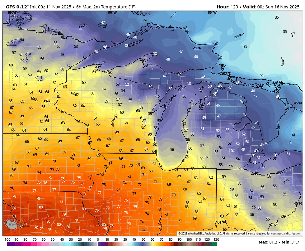
Normal maximums by then range from the mid 40s north to the upper 40s south. That implies some areas could be nearly 30 degrees above average.

The Climate Prediction Center shows a 70-90 percent chance that this burst of warmth happens. Personally, I'm leaning more towards the oddsin the 90th percentile.

One thing I like to see at that distance is consistency amongst models, and both the GFS and EURO meteograms show a 70 degree day in the Quad Cities Saturday.
The GFS

The EURO

Two big takeaways to note that are related to the MJO, (Madden Julien Oscillation) for the 30-day period ending December 10th. See the progression below.

First, the MJO cycles through phase 6 over the next week, which in November correlates to very warm temperatures. The mild readings that are coming are directly tied to that. Second, just before Thanksgiving the EURO shows a transition from phase 6, to 7 and 8 (and most likely phase 1). In December, the temperature analogs for all those phases are cold. If, things unfold as the model indicates, we would be in for an extended period of cold post Thanksgiving right up to Christmas. This is a big development if we can pull that off. It would significantly increase chances of a white Christmas. If you are into snow and cold in December, you want to see the MJO in these cold phases of the western hemisphere at that time.

Just for the pleasure of the eye candy involved, here is what the EURO ensemble mean shows for snow between Thanksgiving and Christmas.

The control run is even better for the same period ending December 25th.

It's important to note, I'm not looking at specific numbers here (nor should you), what I'm trying to establish is a trend and the control is clearly indicating an active storm track from Iowa and northern Illinois into the Great Lakes with enough cold to support snow. Will it happen? Nobody can say, but if we hit the jackpot with the MJO in those phases, chances are far better that it occurs than it doesn't. (60-70%) would be my early assessment.
Meantime, we are going the other direction for the next 6 days with another surge of mild air. Bring it on and roll weather...TS

TSWAILS.COM is now proud to offer expert weather consulting services, including:
Private consulting
Legal forensic services as an expert witness
Public speaking engagements for groups or individuals
Post storm analysis
A private day-long weather school class session
Specialized meteorological needs
Severe weather seminars
Call 563-676-3377 or email terryswails1@gmail.com


Comments