


WET, POTENTIALLY STORMY
- Apr 2
- 3 min read
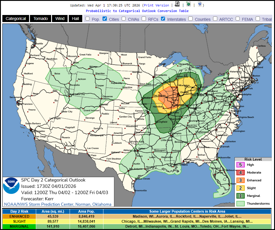
The next 48 hours will feature a very active weather pattern that is likely to bring 1-3 inches of rain and the potential of strong thunderstoms. Currently, the Storm Prediction Center has a level level 3 enhanced risk of storms that includes all facets of severe weather including tornadoe, hail, and strong winds.
As I assess the situation Wednesday night, I can see the potential, but I also see caveats that could diminish the threat. One thing that could thwart stronger storms is how far north the warm front can advance. If clouds and convective debris limit heating, it may not not get much further north than HWY 30. Another factor to consider is how cooler air flowing off Lake Michigan will impede the northward push of the warm front. These two factors will determine the amount of heating and instability that can result.
Below you can see the EURO 51 member esemble solutions show the the warm front getting into SW Wisconsin by late afternoon. That's a plus for a short window severe weather late in the afternoon and early evening

Even so, most of Thursday morning rain and left over clouds limit eventual highs to the mid 60s north to the low 70s south

Due to that, CAPE (instability) is only shown reaching 600 to 1,000 j/kg on the EURO. That is nothing special but low level shear near the warm front could compensate for the lack of overall heating. If strong storms are going to happen it would likely be between 2 and 8 pm from west to east ahead of the triple point. Again, the best chances for tornadoes would be right along the warm front, which should end up near or north of HWY 30. Here's CAPE on the EURO.

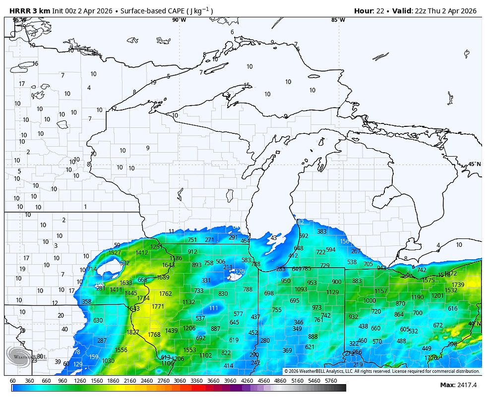
The hi-res convective model the HRRR shows significantly more CAPE than the EURO.
It also shows significant helicity tracks through the central part of my local area. They represent the tracks of long lived supercells. That's a concerning look for that region, especially if it's still on the models late tomorrow morning.
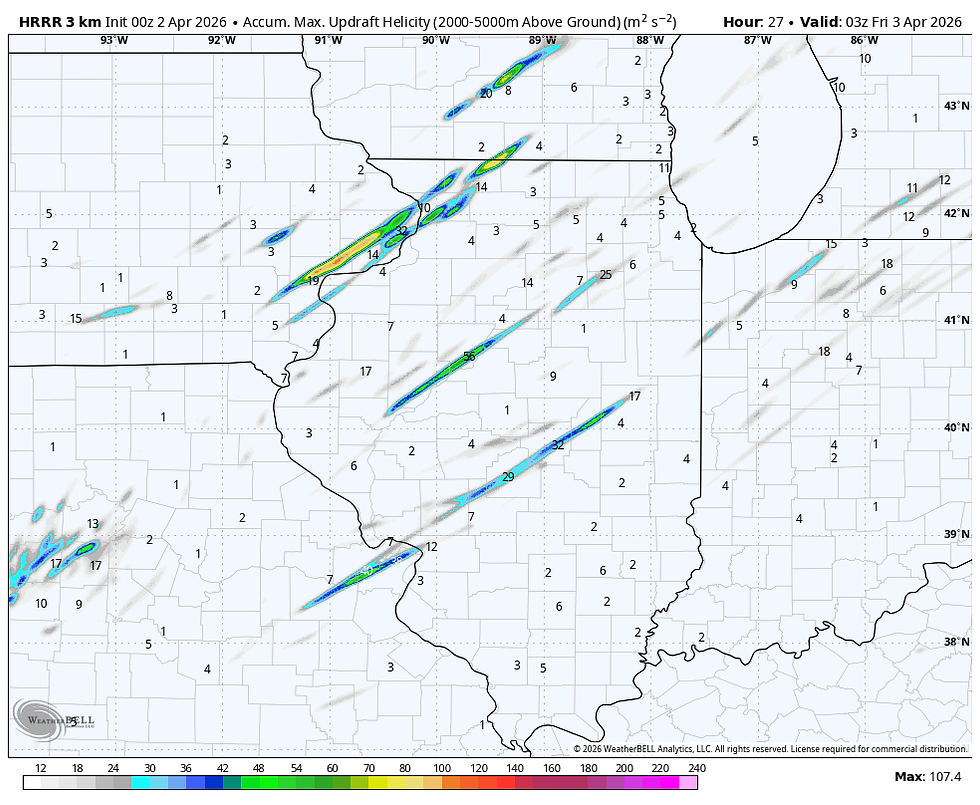
The Rapid refresh, also convective allowing shows a a similar cluster of helicity tracks Thursday afternoon. I like the fact they are a little further SE due to a further south position of the warm front, which is possible

Anway, the potential for some long tracked storms is there, with tornado potential in that zone running from about Washington, Iowa to De Witt and on to Freeport and points southeast. Stay tuned on that. Unfortunately, it's just a bit conditional at this point. Late morning models should tighten up the mesoscale details.
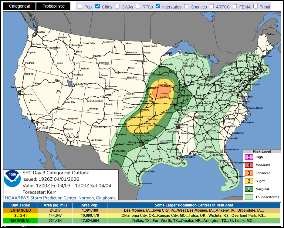
Once the storms depart early Thursday evening, the next system reloads in essentially the same general spot Friday. However, the low seems weaker, somewhat furter south, and slightly slower. That may end up keeping the bulk of the stronger storms further west and south. What my area sees would be in the evening hours, several hours later than Thursday. In fact, much of the day should be dry. Subject to change, this is what SPC is showing for Fridays severe storm risk. The bulk of my area is in a level 3 enhanced or level 2 slight risk outlook. As I mentioned, the best potential runs from Des Moines to the Quad Cities and then south through Keokuk.
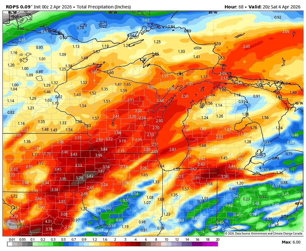
That leads me to the rainfall forecasts which remain pretty healthy. What I'm showing are the amounts through Friday night. Most areas are in line for 1.5 to 3 inches. Some localized higher amounts are certainly on the table. What a windfall that would be.
The EURO

The GFS

The 3k NAM

The Rapid Refresh 3k

The Canadian RDPS 10K
The National Blend of Models

Once the final system blows out Friday night, cool but dry Canadian high pressure dominates Easter weekend. Saturday morning temperatures start in the upper 40s to low 50s Saturday and thats about where they stay the remainder of the day, with a brisk wind. Easter itself looks a bit frisky with highs in the upper 40s to low 50s. Add in a fresh NW breeze and the coat will come in handy for the egg hunts this year. Get those rain gauges out so you can fill em up. Roll weather...TS


Comments