


SEVERE WEATHER TO START THE WEEK
- May 17
- 3 min read

A multi-day severe weather event continues across the Upper Midwest this weekend and will persist into the early part of the week. Damaging wind, large hail an d tornadoes are likely over the next few days, but the bulk of the strongest severe weather may be just west of the Quad Cities region as we mainly get the "leftovers" as the storms slowly weaken heading east.
A Level 3 of 5 Risk is in place Sunday and Monday (Enhanced, Orange) with a Level 4 of 5 Risk (Moderate, Red) off to the west Monday. Sunday and Monday look to have heightened tornado concerns to the west, mainly in eastern Nebraska, northeast Kansas and western Iowa.

Storms are expected to develop Sunday afternoon to the west before congealing into a line and moving east Sunday evening/night. Locally this will likely be a concern for damaging wind gusts and locally heavy rain as the storms are expected to be in a slowly weakening state. Storms may not arrive to eastern Iowa/northwest Illinois until after 3 a.m. Sunday night.

We may have some similarities Monday/Monday night as once again storms are forecast to develop to the west in the afternoon before slowly weakening as they move into our area late Monday. Monday night's storms appear to have a potential to be stronger, with once again damaging wind gusts being the main hazard.
However, if storms can remain strong enough and tapping into the low-level instability/wind shear, a line of storms with embedded tornadoes may be possible Monday night. Given the robust upper-air support, a few strong tornadoes are possible, especially in central Iowa, with this line the evening hours.

The Significant Tornado Parameter (STP) is a rather useful tool for seein the potential for tornadoes as it uses a combination of wind shear and instability. Generally a value of 1+ is what you need to look for to asses a tornado threat. By late Monday evening (8 p.m. CDT above) the HRRR continues to have STP values in the 2-5 range across central Iowa ahead of the merging line of storms. This is what may keep the tornado threat going into the overnight hours.
Nighttime tornadoes are so much more dangerous as they can be extremely difficult, if not impossible, to see. In this case they may be merged in a line of storms as well which will really keep the visibility in check.

While the STP values are dropping by 10 p.m. CDT in eastern Iowa and northwest Illinois, we are still seeing STP of 1-2 which is suffucient for a tornado threat. Again, I think damaging wind gust may be the greatest concern locally, but I do think a few tornadoes would be possible after dark if this line remains organized.
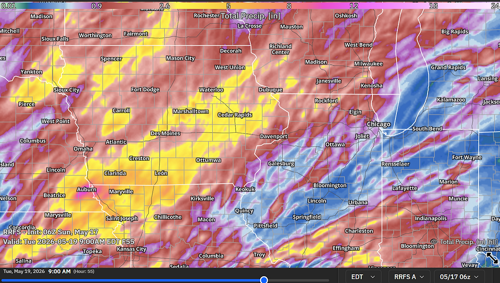
By Tuesday morning, after repeated rounds of thunderstorms, there will likely be some rather high-end rain totals across Iowa and northern Missouri. Given the storms are weakening nightly by the time they reach northern Illinois, totals there may be less. The RRFS has much ogf Iowa in the 2.5" to 4" range through 9 a.m. Tuesday. Following severe storms Saturday across southern Iowa, some areas may be succeptible to flash flooding.

Tuesday looks to be the lowest severe threat of the upcoming stretch, and current modeling shows this could be a morning affair with a line of strong storms producing gusty winds and locally heavy rain passing through the Quad Cities by 9 .a.m. CDT. Higher severe chances look to be to the east/southeast as the line times with the better heating of the day. Following Tuesday, we will get a good break from the storms.

Refreshing temperatures are likely Tuesday-Friday behind the cold front that ends the severe threat Tuesday afternoon. By late May, however, the pattern looks to heat up once again and the pattern may turn more active once again. Only other chance of rain we are looking at in the short term past Tuesday looks like Thursday night with some passing light showers.
Keep your eyes to the sky the next few days and make sure to have ways to get the latest severe weather watches and warnings as they may be needed. Remember, for our area, these storms may be overnight. A Weather Radio is a great way to wake you up at night in the event of severe weather.
Keep Terry in your thoughts as he continues to be a trooper. The latest on his condition can be found on Terry's Facebook page.
-Meteorologist Nick Stewart


The severe weather outlook at the start of the week emphasizes how quickly conditions can shift, with forecasts pointing to strong storms, heavy rain, and potentially damaging winds. These warnings highlight the importance of preparation and staying alert to updates, as even small changes can have significant impacts. It reminds me of Slope game, where maintaining balance and focus through sudden twists is essential—navigating challenges carefully to avoid setbacks and reach safer, more rewarding outcomes.
Thanks for sharing this update on the severe weather outlook. It’s always important to stay aware of changing conditions at the start of the week so people can prepare in advance. Staying alert and informed makes a big difference in safety—kind of like timing your moves in Golf Hit, where good awareness leads to better outcomes.